 
 |
The Geographic Transformer Raster Image Referencing, Transformation, and Mosaicing 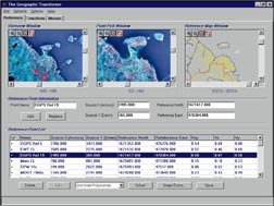 The Geographic Transformer is an invaluable production-proven tool for creating georeferenced image maps for your desktop mapping, GIS, and CAD system. Image data sources include scanned paper maps, aerial photos, and satellite imagery. You can transform an image into a georeferenced image map with an associated ESRI compatible "world file" or MapInfo "table file" in any predefined or custom coordinate system and datum. You can also create output tiles automatically for tiled, seamless coverage of land areas of any size. Additionally, a single seamless image map can be mosaiced from multiple source image maps. The Geographic Transformer is an invaluable production-proven tool for creating georeferenced image maps for your desktop mapping, GIS, and CAD system. Image data sources include scanned paper maps, aerial photos, and satellite imagery. You can transform an image into a georeferenced image map with an associated ESRI compatible "world file" or MapInfo "table file" in any predefined or custom coordinate system and datum. You can also create output tiles automatically for tiled, seamless coverage of land areas of any size. Additionally, a single seamless image map can be mosaiced from multiple source image maps.
• Compatible with ArcView, Arc/Info, MapInfo, Microstation, AutoCAD, the Geographic View, and other GIS, desktop mapping, and CAD systems.
• Supported image formats include: TIFF; Windows Bitmap; JPEG; BSB Chart
• Easily georeference images by interactively selecting reference points. There is even a production proven semi-automatic reference point selection feature that accelerates the registration of maps with regular grid lines.
• Transfer control points directly from your ArcView, MapInfo, AutoCAD, and MicroStation map files. | | Item# | Description | Price Each (U.S.) | | BM106 | The Geographic Transformer | $799 | To order call Toll Free 1-888-333-GEMI ©2000 by GEMI Corp.
All rights reserved. 
| |

