| 
Map Export and Reprojection
• Use with ArcView, Arc/Info, MapInfo, AutoCAD with CAD Overlay
• Specify projection method: UTM, Lambert Conformal Conic, or Transverse Mercator
• Choose from NAD27, NAD83 or WGS84 datum
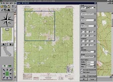
• Export the entire map (with or without map collar), or user-defined sections
• Unrestricted access to map images Features that reduce Survey and Planning Costs
• GPS interface enables transfer
• Measure distance and area of coordinates to and from
• Identify coordinates in State compatible GPS units Plane, Latitude and Longitude,
• Marker and custom editing tools MGRS and UTM coordinate
• GNIS database allows searching systems for manmade and natural features • NGS benchmark data layer
• Unparalleled print quality
• Four Zoom levels System Requirements
Windows 95,98 or NT; 4X CD-ROM drive; Pentium class CPU; 32MB of RAM; and a mouse or drawing equivalent. Network versions available. |