| 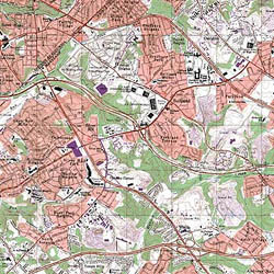
• Complete topographical map coverage of the United States with USGS 7.5 minute topographic maps at 1:24,000 scale
• International maps available from 1:50,000 to 1:250,000 scales
• Seamless tiled mosaic
• Geo-referenced to real-world coordinates
• 16 point control
• 4 bit - 14 color composite
• 250 dots per inch or 400dpi (for additional charge)
• Tagged Image File Format (TIFF) 5.0
State & County Series:
• Any US State in UTM NAD27, meters for $1.99 per map
• Any US State in State Plane, NAD83 feet, for $2.99 per map
• 7.5' USGS topographic maps, 1:24,000 scale
• preprocessed, off-the-shelf
• All maps are color scanned @250 dpi, 4-bit TIFF geo-referenced, seamed
• States are a collection of seamless county sets |