| 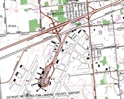 Chartiff Geo's Digital USGS 7.5 Minute, 1:24,000 scale Topographic Maps The collars are first removed from the USGS 7.5 Minute, 1:24,000 scale topographic map (DRG map), then cropped to the map extents. The voided areas of the map are then filled with the necessary adjacent map information to make the map and Tiff file rectangular. Chartiff Geo's Digital USGS 7.5 Minute, 1:24,000 scale Topographic Maps The collars are first removed from the USGS 7.5 Minute, 1:24,000 scale topographic map (DRG map), then cropped to the map extents. The voided areas of the map are then filled with the necessary adjacent map information to make the map and Tiff file rectangular.
ChartTiff Geo raster images are geometrically registered at the pixel level from map to map; even from degree to degree. ChartTiff Geo raster images allow for easy panning from one map to another, without worrying about map overlap and transparency problems associated with other map products. The Tiff files are then enhanced to the ChartTiff format with additional tags. ChartTiff is a superset of the GeoTiff standard. Each ChartTiff Geo degree set includes:
• 64 - (1:24,000 scale) files (maybe less than 64 files if degree bounded by water).
• 2 - (1:100,000 scale) files
• 1 - (1:250,000 scale) file
• The World (.tfw) files.
• The MapInfo (.tab) files.
•The full set of Original USGS DRGs with collars and their
corresponding world files are also included with each ChartTiff Geo set These two images are an example of before and after 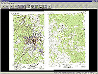 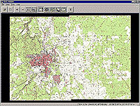
|