| 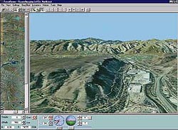
CARTERRA™ 3D - 5-Meter U.S. Geological Survey Digital Ortho Quad Add a new dimension to your analysis
• Interactive 3D Visualization Tool
• MMX PC-Based - Easy to use and cost effective
• Includes 3D Visualization Software, Digital Elevation Model, Orthorectified 5-Meter Imagery
This interactive product allows users to freely navigate the data and visualize terrain, transportation infrastructure, mountains, valleys, watersheds and other natural and cultural features in three dimension.
Used as a simulated fly-through, CARTERRA™ 3D can help city planners determine whether and where to place a road network or housing development or park. The interactive flight capabilities can also be used to visualize the potential impact of new development on the environment, monitor deforestation practices in remote mountain areas, or illustrate existing or projected growth in a developing area. This product could even be used to evaluate real estate properties for companies considering building a new facility halfway across the country. |


