| 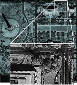 One-meter resolution satellite imagery from IKONOS now provides clear concise pictures of anywhere in the world. This imagery is used by government agencies, planners, utilities and others wherever high quality imagery is required. Imagery is provided in simple rectified format, Geo, or 3 levels of orthorectified products: Reference (25m accuracy), Pro (10m accuracy) and Precision (4 meter accuracy). The satellite may be tasked to pick up new imagery or, imagery may be selected from the ever expanding archive. In most cases, archived imagery is delivered very quickly. Four meter multi spectral, fused 1-m pan sharpened products are also available. One-meter resolution satellite imagery from IKONOS now provides clear concise pictures of anywhere in the world. This imagery is used by government agencies, planners, utilities and others wherever high quality imagery is required. Imagery is provided in simple rectified format, Geo, or 3 levels of orthorectified products: Reference (25m accuracy), Pro (10m accuracy) and Precision (4 meter accuracy). The satellite may be tasked to pick up new imagery or, imagery may be selected from the ever expanding archive. In most cases, archived imagery is delivered very quickly. Four meter multi spectral, fused 1-m pan sharpened products are also available.
Minimum order is 100 square km prices are for Company/Agency license, please call for Corportation/multi agency license prices are for North America, please call for international pricing |


