| 
CARTERRA™ World Views
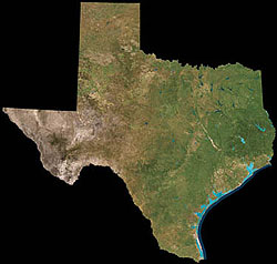
This satellite image product provides a wide-area, comprehensive view of the entire U.S. at 180-meter resolution. The color imagery is available for the US. or as smaller subsets covering a region or state, and is packaged with separate files containing graphical overlays of state boundaries, interstate highways, and state capitals. The imagery is cloud free and color-balanced for maximum distinction of detail. Markets for this product include natural resource planning, regional mapping and vegetation indexing to urban planning, tourism, media and consumer applications. The product provides a colorful backdrop for presentations, news and weather reports, travel maps, and encyclopedias. It makes an excellent real-world layer in a GIS or visualization software package.
Product Description
Best possible mosaic, cloud-free, radiometrically corrected, seamless, colorized image of the Continental United States. Product is two WiFS bands (red, near-IR) or true color derived from these two bands. Resultant 3-band TIFF images provide a baseline from which other data products can be derived, or the resultant image can be marketed as a stand-alone product. Data Source: IRS-1C and/or IRS-1D WiFS 180 meter
Processing level: Map oriented
Projection: Lambert Conformal Conic (LCC) (45.0, 33.0, W 100.0 degrees
Datum: NAD 83
Resampled interval: 180 m
Resampled method: Cubic Convolution (CC)
Standard files: TIFF geophoto files (24 bit, tiled, uncompressed, no (LUT) |


