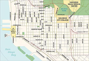
 GDT's flagship Dynamap/2000 database contains more than 14 million addressed street segments along with postal and census boundaries, landmarks and water features. To ensure completeness and up-to-date accuracy, Dynamap/2000 incorporates more than one million changes every quarter. Dynamap/2000 maps are aesthetically pleasing with fine visual detail providing clean, straightened lines, curvy roads and cloverleaf ramps, to reflect real-world road conditions. It also includes improved census boundaries and the highest quality ZIP code boundaries available. New streets, renamed highways, ZIP code revisions and other changes occurring in our nation's dynamic landscape are updated quarterly. GDT uses a number of quality control techniques, including raster imagery, to verify new roads and improve the spatial accuracy of the data. As a result, customers consistently credit GDT with the highest nationwide geocoding rates in the industry. Strong geocoding performance helps ensure a high level of accuracy for site selection, risk analysis, emergency services, sales territory management and other applications. |


