
|

|

|
|
|
|
|
|
|
|
|
EOM August 2005 > Departments > Fire!
Satellite-Based Fire Detection and Mapping For The Eastern United States
Brad Quayle
Introduction
The USDA Forest Service Moderate Resolution Imaging Spectroradiometer (MODIS) Active Fire Mapping Program provides daily operational fire detection data, satellite imagery, and fire mapping products for the continental United States and Alaska. This effort is a result of a partnership between the Forest Service Remote Sensing Applications Center (RSAC), NASA Goddard Space Flight Center (GSFC), the University of Maryland, and a network of MODIS ground stations operated by various institutions throughout the country. The objective of the program is to leverage synoptic view, high temporal remote sensing imagery, and fire detection locations observed by MODIS to produce a suite of fire-related geospatial products. Products and information provided by the program are valuable for monitoring the current location and extent of fire activity throughout all geographic areas of the United States.
The rationale for the MODIS Active Fire Mapping Program grew from experience gained by the Forest Service and other federal land management agencies during the catastrophic western United States fire season in 2000. Initiated in 2001, the original program focus was to monitor the fire activity that occurs annually in the western states. Annually, however, the Eastern and Southern Geographic Areas (Figure 1) collectively comprise nearly 21 percent of the wildland fire acreage in the United States and 66 percent of the prescribed fire acreage. Although large individual fires in the eastern United States are infrequently compared to those that occur annually in the western United States and Alaska, these statistics show the significant degree of fire activity that occurs in eastern states. As a result, in 2002, the MODIS Active Fire Mapping Program expanded to provide operational fire detection and monitoring coverage for the eastern United States.
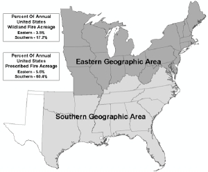
Figure 1: Extent of the Eastern and Southern Geographic Areas as designated by the interagency wildland fire community. These areas comprise 21 percent of the annual 4.4 million wildland fire acreage in the United States and 66 percent of the annual 1.9 million prescribed fire acreage. Click on image to see enlarged.
MODIS Active Fire Detection For The Eastern United States
| INSTRUMENT | Type | Multi-spectral cross track scanning radiometer | View Angle | 110° (+/- 55° from nadir) | Swath | 2,330 KM swath (cross track); 10 KM (along track) |
Spectral Resolution | 36 bands (0.4µm to 14.4µm, Visible to Thermal Infrared) | Spatial Resolution | 2 @ 250 meters, Red/NIR (Bands 1 & 2) 5 @ 500 meters, Visible to MIR (Bands 3 — 7) 29 @ 1 KM, Visible to TIR (Bands 8 — 36) |
Temporal Resolution | Once daily for collection of solar reflective bands (at latitudes greater than 30 degrees); Twice daily for collection of thermal bands (at latitudes greater than 30 degrees) |
Quantization | 12 bits | Geolocational Accuracy | +/- 50 meters |
|---|---|
| ORBIT | Type | Sun-synchronous, near polar orbit | Altitude | 705 KM | Inclination | 98.2° degrees | Equatorial Crossing | 10:30 a.m. descending node (Terra); 1:30 p.m. ascending node (Aqua) |
| GENERAL | Launch Date | December 18, 1999 (Terra); May 4, 2002 (Aqua) |
Design Life | 6 years |
The MODIS instrument is onboard two polar-orbiting NASA Earth Observing System (EOS) platforms, Terra and Aqua. MODIS collects high temporal image data for 36 co-registered spectral bands at one of three spatial resolutions — 250-meters, 500-meters, and 1-kilometer. Designed to monitor a host of Earth's land, ocean, and atmospheric processes, MODIS has several unique technical characteristics unprecedented in a high temporal, moderate resolution, polar-orbiting sensor (Table 1). MODIS' multiple thermal bands, with relatively high saturation thresholds and excellent geolocational accuracy, facilitate an improved capability for global fire detection and monitoring multiple times daily at a spatial resolution of 1-kilometer.
The combination of both MODIS sensors provides at least four daily thermal observations at latitudes greater than 30°. Daytime MODIS thermal observations are acquired by Terra at approximately midday and again at midnight. The MODIS sensor onboard Aqua acquires data over the same area approximately two and a half hours after each Terra observation. The timing of the MODIS thermal observations provide for diurnal monitoring of fire activity.
Fire detections are gleaned from MODIS image data by measuring the response of potential fire pixels in the 4µm and 11µm bands and by applying subsequent absolute thresholds and contextual analyses to determine the presence of a fire for a given pixel. Specific algorithm modifications are applied to address different atmospheric and land surface conditions present on daytime versus nighttime observations.
Immediate access to MODIS imagery and derived fire detection locations is facilitated by the Rapid Response System (RRS) developed by GSFC and the University of Maryland. The RSS is an automated image processing system that processes MODIS image data, extracts fire detection locations, and associated fire characteristics, and provides georeferenced corrected reflectance imagery. Fire detection processing in the RSS uses the same algorithm utilized by the MODIS Adaptive Processing System (MODAPS) to produce the Level 2 MOD14 Fire and Thermal Anomalies product. The Level 2 MODIS fire product identifies active fires and other thermal anomalies at a spatial resolution of 1-kilometer and is the key data theme in the MODIS Active Fire Mapping Program. The Level 2 MOD14 product is available from the Land Processes Distributed Active Archive Center (LP-DAAC) within days of MODIS image data acquisition; however, this delay minimizes its use for operational fire detection and monitoring.
As the data source for the MODIS Active Fire Mapping Program, Rapid Response operates as a distributed system. The main RSS is located at GSFC and processes near real-time MODIS data (2-4 hours post-acquisition) for the entire United States. This raw image data is made available to the GSFC RSS via a bent pipe feed from the NOAA MODIS Near Real Time Processing System. In addition to the main RSS at GSFC, there are several instances of the RSS data processing framework residing at MODIS direct readout ground stations throughout the United States. MODIS direct readout ground stations collect daily real-time MODIS data for extensive geographic areas. In the direct broadcast/direct readout scenario, MODIS image data are continuously broadcast directly from both MODIS sensors as they orbit overhead. Appropriately equipped ground stations can collect raw image data broadcast by MODIS while maintaining line of sight visibility to the sensor. These real-time MODIS data are immediately processed to extract fire locations using the RSS data processing framework on site.
Continued below ...

|
|
|
|
|
|
|
|
|
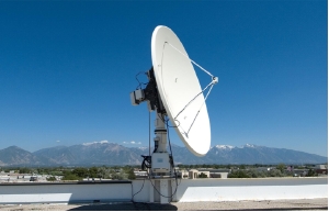
Figure 2: MODIS ground station at the Remote Sensing Applications Center facility in Salt Lake City, Utah. Click on image to see enlarged.
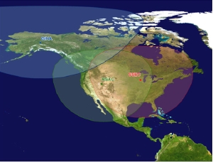
Figure 3: Nominal MODIS station coverage area provided by the RSAC, SSEC and GINA MODIS ground stations. Each station collects MODIS image data broadcast directly from the sensor. Direct broadcast of MODIS image data for the surface of the Earth viewable to the sensor is available to the ground stations while the orbit path of either Terra or Aqua intersects the respective station coverage area. Click on image to see enlarged.
For the MODIS Active Fire Mapping Program, real-time MODIS fire detection data coverage for the eastern as well as the western United States is facilitated by MODIS direct readout ground stations (Figure 2) managed by RSAC in Salt Lake City, Utah and by the Space Science and Engineering Center (SSEC) at the University of Wisconsin in Madison, Wisconsin. The combined ground station footprint of these two facilities combined with an additional partner MODIS ground station at the University of Alaska-Fairbanks Geographic Information Network of Alaska (GINA) facilitate real-time, day/night MODIS image coverage for nearly the entire North American continent (Figure 3). Raw fire detection data produced by the RSS data processing framework at GSFC and each of the three ground stations are continuously integrated into the MODIS Active Fire Mapping Program at RSAC. The near real-time fire detection data provided by GSFC augments the real-time data provided by the MODIS ground stations and serves as an alternative data source when necessary.
MODIS Active Fire Mapping Products For The Eastern United States
Raw fire detection data are compiled and processed by the MODIS Active Fire Mapping Program to provide several value-added geospatial products 24 hours daily, year round. The operational products provide a comprehensive assessment of the current fire activity and extent for the eastern United States, and the rest of the country, based on the most recent MODIS observations.
The MODIS Active Fire Mapping products are intended for use at regional and national scales by fire managers for current fire situation assessment and strategic response. The products can also be used with local fire information (e.g., National Incident Management Situation Report, National Fire Plan Operations and Reporting System, etc.) to provide contextual information. The integration of MODIS fire mapping products with various available sources of ancillary information facilitates an integrated decision support system for the management of wildfire and prescribed fire activity. Notable MODIS Active Fire Mapping Program geospatial products that cover for the eastern United States include the following:
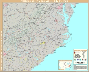
Figure 4: An example of a MODIS active fire detection map covering Virginia, North Carolina and South Carolina. Click on image to see enlarged.
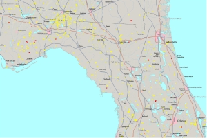
Figure 5: A subset of a MODIS active fire detection map displaying recent and cumulative year 2005 MODIS fire detection activity for northern Florida on 2005 April 29. MODIS fire detections in the last 12 hours are depicted in red; last 24 hours in orange, and previous detections in yellow. Click on image to see enlarged.
Hardcopy Fire Detection Maps — Digital versions of regional scale hardcopy maps displaying cumulative and recent MODIS fire detection activity (Figures 4 and 5). The design of the mapping areas is determined by "Geographic Area" boundaries designated by the interagency wildland fire organizations. Fire suppression resources are coordinated within each Geographic Area to respond effectively to wildland fire incidents within respective geographic areas as well as to provide assistance to other Geographic Areas when necessary. To facilitate the needs of individual Geographic Areas, 21 poster-size MODIS fire detection maps are produced, including nine maps covering the eastern United States (east of the Mississippi River). The hardcopy MODIS fire detection maps are updated multiple times daily as fire conditions warrant in respective mapping areas. Maps of Geographic Areas experiencing extreme wildland fire activity are updated up to four times daily after local MODIS observations.
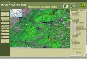
Figure 6: Web-based, interactive MODIS fire detection maps provided by the MODIS Active Fire Mapping Program display fire detection data with user-selected map layers at user-defined map extents and scales. Click on image to see enlarged.
Interactive Fire Detection Maps — Web-based, interactive fire detection mapping applications for the United States. Users can pan/zoom to a user-specified scale and integrate MODIS fire detection data with various GIS layers and image data (Figure 6). MODIS fire detection data are updated hourly and are available in conjunction with fire detection data provided by NOAA NESDIS from other high temporal sensors. MODIS fire detection GIS data layers compiled and processed by the MODIS Active Fire Mapping Program are also continually relayed to other Web-based, fire support mapping services, including GeoMAC.
Fire Detection GIS Data — Hourly updates of cumulative 1-kilometer MODIS fire detection datasets for the entire United States. Current and historical MODIS fire detection GIS datasets include attribute fields describing fire characteristics and are compiled from MODIS Rapid Response processing output at GSFC and MODIS ground stations at RSAC, SSEC, and GINA. These MODIS fire detection GIS datasets are also mirrored at the Geospatial One Stop.
Fire Detection Summaries — Cursory map and tabular summaries describing the most recent MODIS fire detection locations for the United States. Fire detection maps and summaries are provided in the context of key thematic information, including land cover type, administrative unit, nearest populated place, forecasted fire danger rating, and current fire weather conditions.
Future Of The Program
In preparation for the post-MODIS era, the MODIS Active Fire Mapping Program is preparing to leverage the next generation of moderate resolution sensors capable of fire detection and monitoring. Future sensors are expected to provide fire detection data at relatively higher spatial resolution and assess additional characteristics about observed fire activity.
Currently, RSAC is making preparations to integrate the Visible/Infrared Imager/Radiometer Suite (VIIRS) in the near future. VIIRS is a follow-on sensor to the Advanced Very High Resolution Radiometer (AVHRR) and will fly on the National Polar-Orbiting Environmental Satellite System (NPOESS). The first NPOESS satellite is scheduled for launch in 2009 preceded by the launch of an EOS-NPOESS bridging mission, the NPOESS Preparatory Project (NPP), in late 2006. The VIIRS instrument onboard NPP and NPOESS is expected to collect global fire detection data at a spatial resolution of 750 meters. With a planned constellation of three NPOESS satellites orbiting the Earth before the middle of the next decade, VIIRS will provide six daily thermal observations for fire detection and monitoring. ![]()
Acknowledgments
The author would like to acknowledge several entities that make the USDA Forest Service MODIS Active Fire Mapping Program possible. These entities include NASA Goddard Space Flight Center and the University of Maryland for the development and implementation of the RSS data processing framework; the NOAA MODIS Near Real Time Processing System for providing access to the near real-time MODIS data stream; and the University of Wisconsin Space Science and Engineering Center and the University of Alaska-Fairbanks Geographic Information Network of Alaska for providing access to real-time MODIS imagery and fire location data.
Further Reading
Descloitres J., R. Sohlberg, J. Owens, L. Giglio, C. Justice, M. Carroll, J. Seaton, M. Crisologo, M. Finco, K. Lannom, and T. Bobbe, 2002: The MODIS Land Rapid Response project. IGARSS: IEEE International Geoscience and Remote Sensing Symposium Proceedings, Toronto, 2002.
Giglio, L., Descloitres, J., Justice, C. O., and Kaufman, Y. J., 2003: An enhanced contextual fire detection algorithm for MODIS. Remote Sensing of the Environment, 87, 273-282.
McNamara, D., G. Stephens, B. Ramsay, E. Prins, I. Csiszar, C. Elvidge, R. Hobson, and C. Schmidt, 2002: Fire Detection and Monitoring Products at the National Oceanic and Atmospheric Administration. Photogrammetric Engineering and Remote Sensing 68, 774-775.
National Aeronautics and Space Administration, 2005: MODIS Fire and Thermal Anomalies Guide. Online technical reference, accessed April 18, 2005. URL: http://modis-fire.umd.edu.
National Interagency Coordination Center, 2005: National Interagency Coordination Center 2004 Statistics and Summary. Accessed April 15, 2005. URL: http://www.nifc.gov/news/2004_statssumm/2004Stats&Summ.html.
About the Author
Brad Quayle is a remote sensing/geographic information system specialist in the Operations Program of the USDA Forest Service Remote Sensing Applications Center in Salt Lake City, Utah.
|
|
|
©Copyright 2005-2021 by GITC America, Inc. Articles may not be reproduced, in whole or in part, without prior authorization from GITC America, Inc. The original version of this article can be found at: https://www.eomonline.com/EOM_Jul05/article.php?Article=department03 |