|

|

|
|
|
|
|
|
|
|
|
EOM August 2005 > Features
2005 Hurricane Season — More Hurricanes to Come!
By Dave Jones
Even though there has already been a record number of named tropical systems in the Atlantic Basin this July (seven tropical storms, with two becoming major hurricanes), most of the activity is still expected to occur during the peak months of August-October.
The National Oceanic and Atmospheric Administration (NOAA) is calling for a 95-100 percent chance of an above-normal 2005 Atlantic hurricane season, according to a consensus of scientists at NOAA's Climate Prediction Center (CPC), Hurricane Research Division (HRD), and National Hurricane Center (NHC). This forecast reflects NOAA's highest confidence of an above-normal hurricane season since their outlooks began in August 1998.
The updated outlook calls for an extremely active season, with an expected seasonal total of 18-21 tropical storms (mean is 10), with 9-11 becoming hurricanes (mean is six), and five to seven of these becoming major hurricanes (mean is two to three). This forecast is 180 percent to 270 percent of the median.
The main uncertainty in this outlook is the number of landfalling tropical storms and hurricanes in the United States and the region around the Caribbean Sea. Although the conditions that produce hurricane landfalls are well-known, they are very difficult to predict at these extended ranges because they are often related to the daily weather patterns rather than the seasonal climate patterns. It is currently not possible to confidently predict the number or intensity of landfalling hurricanes at these extended ranges, or whether a given locality will be impacted by a hurricane this season.

Figure 1: Hurricane Dennis makes landfall as a category 3 hurricane (winds of 111-131 miles per hour) around Navarre Beach, Florida as observed by the Moderate Resolution Imaging Spectroradiometer (MODIS) sensor on board NASA's Terra satellite. Image provided by the NASA Modis Rapid Response team processed by StormCenter Communications. Click on image to see enlarged.
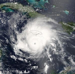
Hurricanes Dennis and Emily were the two most intense storms, with Dennis making landfall on the Florida panhandle and testing the resolve of the residents there. Hurricane Emily approached category 5 in the Caribbean prior to making landfall south of Cancun, Mexico and again in Mexico about 75 miles south of Brownsville, Texas.
Continued below ...

|
|
|
|
|
|
|
|
|

Figure 2: Hurricane Emily, the season's second major hurricane is shown above when it peaked in its intensity. In this image, Emily is packing winds of 155 miles per hour (just below category 5) and a central pressure of 937 millibars or 27.67 inches of mercury. Image provided by the NASA Modis Rapid Response team and processed by StormCenter Communications. Click on image to see enlarged.
Residents, emergency managers, and decision-makers relied on satellite imagery from NOAA polar-orbiting and geostationary satellites to follow the storms. These critical space-based weather observatories provide critical input to numerical weather prediction models and provide the ability to view cloud motions that significantly aid forecasters. ![]()
About the Author
Dave Jones is President and CEO of StormCenter Communications, Inc. He can be reached at [email protected].
|
|
|
©Copyright 2005-2021 by GITC America, Inc. Articles may not be reproduced, in whole or in part, without prior authorization from GITC America, Inc. The original version of this article can be found at: https://www.eomonline.com/EOM_Jul05/article.php?Article=feature04 |