|
TRUVUE
Puts Satellite Imagery on Every Desktop
TRUVUE
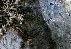
OverVue is an intelligent image map of
the contiguous United States with image, graphics, and
terrain information in one integrated package. Offers
the most complete picture of your regional area: populated
places, roads, waterways, terrain elevations, forests,
and farmland. OverVue can be used as delivered with
its accompanying TruVuer software...or import
OverVue to your GIS or desktop mapping program. You
can order just the area you need, and it will be in
your
hands in a few days.
OverVue product specs:
• 25 meter color image from bands 7,4,2 Landsat
TM
• 400 meter reduced resolution index image
• Digital terrain data (derived from USGS DEM)
• Vectors (major roads and water features derived
from USGS DLG)
• County boundaries
• Geographic names
• TruVuer software
|