| Environmental Applications of ESE Data and Information
By Kevin P. Corbley and Thomas H. Mace, MS, Ph.D. Environmental change touches all of us in both direct and indirect ways. In some severe cases (i.e., natural disasters) we see the consequences and effects directly. Most of the time, however, the effects are more subtle. For example, exposures to ozone or acid deposition may weaken tree resistance to insect infestations and affect forest management options, or changes in agricultural pesticide and herbicide use may affect the movement of sediments and pollutants into streams and estuaries, ultimately impacting estuaries and even deep water fisheries. Monitoring, mitigation, and adaptation strategies in response to these, indirect causes requires a systems science approach that cuts across all of the sectors, making full use of remote sensing in concert with in situ (field) measurements and coupled models. Natural and human sources of change become intermixed as they drive the changes we see in ecosystem and human health.
Understanding the impacts of natural and human change on the global environment lies at the heart of NASA's Earth Science Enterprise program. Sound environmental management also requires knowledge of the condition of the Earth's land, water, and air, as well as the impact of human activity on these resources. While the focus of ESE is characterization of variables that are related to research on global environmental condition and change, the same instruments that measure global change research parameters can be used to provide local, state, and federal researchers, managers, and regulators, as well as private interests, valuable information on the environment.
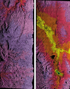 Integrated AirSAR processor image of Ray Mine, Arizona, on 17 April 1995. Therefore, researchers and practitioners around the world anxiously await the launch of the latest ESE sensors that will offer insights into the complex interactions of terrestrial, marine, and atmospheric environmental systems with the human dimensions of global environmental change.
Two important platforms in this program are now in orbit-the Tropical Rainfall Measuring Mission (TRMM) and the Sea-viewing Wide Field-of-view Sensor (SeaWiFS) mission-and several legacy missions are still returning useful data (Landsat 5, the AVHRR, and TOMS). This year, the highly anticipated Landsat 7 and Terra satellites will join the others in orbit, providing global environmental measurements. Some other upcoming missions of interest to environmental monitoring are the Shuttle Radar Topographic Mapper (SRTM) launching this fall, EO-1 launching in 2000, and Vegetation Canopy Lidar (VCL) launching in 2001.
The Enhanced Thematic Mapper Plus (ETM+) will be carried aboard Landsat 7 and maintain continuity in land monitoring programs initiated in 1972 by the first Landsat. Of the five instruments onboard Terra, MODIS, ASTER, and MISR offer great promise for terrestrial environmental applications, as well as information on the atmosphere and hydrosphere. A fourth, MOPITT, will provide critical information on atmospheric methane and carbon monoxide distributions world wide. The fifth, CERES, will provide important information on the Earth's energy budget and will indirectly support environmental monitoring. Follow on missions, for example, the TES instrument on the CHEM mission, will have far-ranging implications for environmental monitoring. The environmental applications challenge
ESE instruments will be very important to both the environmental research community and the operational environmental monitoring community. In fact, many scientists and engineers believe both private and public sector environmental management programs may benefit from ESE data, more so than any other applications group. However, barriers exist that must be overcome before ESE data become widely used and accepted.
In the past, cost was one of the major barriers to environmental applications. Many industries that regularly utilize satellite remote sensing imagery, such as agriculture, forestry, civil engineering, and energy exploration, realize near-term economic gains through its use and can justify its cost. In environmental projects, however, the economic gains can be long-term and may weigh against very tight budgets. At $3-4,000 per scene, environmental managers were reluctant to purchase imagery that would stress their project budgets with image acquisition costs. Availability of ESE satellite data at the cost of reproduction, as well as Landsat 7 imagery at $475-$600 per scene, is expected to ignite an increased demand for imagery in a variety of non-research oriented environmental applications. It should also spur growth in the value added interpretation services and analysis software industries, as demand quickly increases beyond in-house capacity in environmental organizations.
Another factor that has historically hindered widespread use of satellite imagery for environmental purposes is a lack of practical knowledge of remote sensing and its applications. "What has to be done for industry to start using data for environmental management purposes is for them to see applied research that links satellite data and information," says Professor Bob Vincent of Bowling Green State University. "Researchers have to prove you can get meaningful information out of this data."
He believes the experimental projects carried out by ESE partners, including a significant number of the ESIPs and RESACs, will pave the way for similar applications in the private sector. Vincent points out that while industry will not spend the money to perform basic research, it will take whatever results are proven in the lab and make profitable business applications from them.
Similarly, government managers at all levels of government are largely unaware of the benefits of integrating remote sensing into their environmental monitoring portfolio. The research community needs to begin a concerted effort to document and verify practical applications, and then communicate them beyond a narrow audience of fellow researchers. Outreach activities, such as the Global Change Research Information Office (GCRIO) and the Global Change Data and Information System (GCDIS) address an important component of this process, as do the professional societies, such as the American Society for Photogrammetry and Remote Sensing, and various university programs across the country. The private sector also has a responsibility to maintain very high ethical standards as they offer their services to the emerging user community for information derived from remotely sensed data.
Finally, availability of appropriate imagery has been a major barrier. As we began the decade of the 90s, there were relatively few instruments and environmental applications that weren't dependent on a single instrument, like Landsat, SPOT, or AVHRR, and usually a single date. By the end of the 90s, ESE and related missions in both the government and commercial sectors all around the world will have created a matrix of sensors, with different, yet complimentary, resolutions and timing. This data-rich environment will move applications from being feasible in only a research mode to operationally feasible. Multiple sensors such as Landsat ETM and MODIS can be used productively to monitor different aspects of the same problem, virtually simultaneously, working together with models and field measurement programs to produce a convergence of evidence at multiple scales. Similarly, multiple instruments can be used for calibration, and the calibrated data can be used to produce maps of biological variables such as photosynthesis, biomass, and vegetation condition important to monitoring ecological health.
The need to reduce costs, expand awareness, and for available and synergistic imagery are challenges all potentially addressed as we emerge from the 20th century. The "systems approach" has brought the ability to monitor key environmental variables at appropriate spatial and time scales to environmental monitoring. The result will be increased use of risk assessments as a way to focus on preventing pollution and environmental damage, rather than the extremely expensive strategy of environmental cleanup. There will always be room for improvement, but ESE missions and the concurrent outreach and applications studies provide a major step forward in the U.S.' capacity for effective environmental monitoring at scales from local to global. 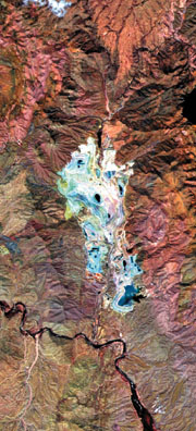
Ray Mine, Arizona, from the AVIRIS mission flown by NASA on 16 April 1997. Enhancement simulates color infrared imagery. The Environmental Applications
The national goals of clean air, clean water, and healthy ecosystems are a few of the primary forces that drive the need for better environmental monitoring. Recently, the environmental monitoring community has begun to understand that we need to monitor indicators of ecological change in addition to particular pollutants in air, water, and on land. Among these indicators are elements of the landscape itself. Land surface topography, land cover, surface temperature, and soil moisture are examples of variables that may be measured by ESE observatories that have a direct relationship to the condition of water resources. Changes in landscape pattern are also important. For example, forest cover patch size may be as important as total forest area for assessing risk to habitat, or the real effect of row crops on erosion, and water pollution may be estimated with greater accuracy if slope values are known, as well. These are relatively simple examples, and more complex applications will be enabled by the new sensors. The improvements in land surface imaging brought about by Landsat ETM+, MODIS, ASTER, MISER, and the more experimental EO-1 are likely to have profound effects on our ability to measure and monitor these, and more complex, landscape indicators. These indicators then become inputs to models which project regional vulnerability and assess the risks associated with a variety of management and regulatory decisions.
Direct measurements of pollutants in coastal and inland waters are much more difficult. SeaWiFS and MODIS can provide measurements at high repeat intervals but low spatial resolution, while ASTER and Landsat have better spatial resolution but the low return visit rate in normally cloudy areas will continue to be an operational problem. Water surface temperature should be considered operational, but the algorithms for inverting radiance that are successful in the open ocean are only partially successful in dealing with combinations of materials (i.e., dissolved organic carbon, chlorophyll a, and sediments) and a less homogeneous (i.e., urban) atmosphere.
This is an area of active research, however, and the instruments can currently detect relative concentrations reliably and absolute concentrations under some conditions. This relative information can be especially useful in directing field sampling efforts and in detecting severe events, such as harmful algael blooms, in near real-time. Research linking models of pollutant transport by the atmosphere and surface waters, field measurements, and airborne laser-induced fluorescence measurements may drive the state of the science dramatically forward, allowing new opportunities for operational monitoring.
Long-range transport of atmospheric pollutants, especially ozone and fine particulates, is a major issue for environmental regulation. Wide field of view instruments, like SeaWiFS, have already been used for qualitative estimates, and ultimately, the Terra sensors will be used for quantitative estimates of the effects of long range transport of these two important components of the atmosphere. MOPITT will measure concentrations of two other important gasses-methane and carbon monoxide. The EO-2 mission will experimentally measure winds, and the CHEM mission, following on the heels of the PM-1 mission, has a suite of instruments measuring atmospheric chemistry.
These instruments all operate at or above the spatial resolution of current transport models and will contribute both to the improvement of the models, providing important snapshots in time of boundary conditions and calculated variables. One drawback for environmental monitoring is that atmospheric conditions are very dynamic over a given region, making a polar orbit less desirable than a geostationary one. However, when used in concert with models and field sampling, ESE polar orbiting satellites may make a major contribution to monitoring a number of very important pollutants at a variety of scales.
It is estimated that there may be over 20,000 active and abandoned mines in the western U.S. alone. To inventory and assess the potential impact of each of these mines on surface water quality, by field methods alone, is a daunting task. Mine owners, themselves, are often uncertain of the risks their properties pose, if any. So, both the regulating and regulated communities have a vested interest in the development of survey technologies that can rapidly sort out relative risks from a large number of potential sources. Currently, the potential use of ESE experimental airborne sensors, including the hyperspectral sensor, AVIRIS, is being evaluated to operationally inventory and screen problem sites. If successful, they, and the follow on satellite systems, will provide rapid means for assigning risk to ecosystem and human health, based on the abundance and location of acid mine drainage-producing minerals. In this case, ESE research sensors may also generate sufficient interest to encourage the development of private, airborne systems to fill an environmental monitoring need.
Additional applications in the environmental sector-which includes both commercial contractors, local and regional government, non-profit organizations, and non-governmental organizations-include urban encroachment mapping and heat island effects, deforestation and wetlands monitoring, irrigation water allocation, siting for solid waste disposal, and assessing environmental impact of droughts, floods, and natural disasters. From these examples, and many others, it is reasonable to conclude that the environmental monitoring sector may benefit more than any other from the wealth of new environmental measurements to be generated every day by ESE. Though designed to reduce the uncertainty in global change models, the systems developed by ESE are going to have a profound effect on environmental monitoring at multiple scales, throughout the world. We are entering an entirely new era in remote sensing of the environment. About the Authors:
Kevin Corbley is a freelance writer and consultant specializing in remote sensing, GIS, and GPS. He lives in Denver, Colorado, and may be reached at 303-722-0312 or by E-mail at [email protected] Dr. Thomas H. Mace is an environmental scientist with the U.S. Environmental Protection Agency with over 20 years experience in remote sensing and GIS in both the government and the private sectors. He is a liaison between NASA and EPA for ESE, an adjunct science team member for MODIS and ASTER, and chairs the federal interagency working group responsible for global change data and information. E-mail [email protected] Back |

