| Local, State, and Regional Government and Planning Applications for
Remote Sensing
By Timothy W. Foresman, Ph.D. Growth of Remote Sensing in Governance Community
After more than 25 years of satellite-based land remote sensing experimentation and development, these technologies have reached almost all sectors of Earth science applications, including planning and governance. The use of remote sensing data and derivative information has every promise of entering into the mainstream of governing at local, state, and regional levels. Advances in computing technology, acceptance of geographic information systems (GIS), and maturity of the university, state, and industry associations for sustaining remote sensing awareness and training indicate a favorable environment for diffusion of this technology into state and local governments. In addition, the Terra sensor suite and other ESE missions will be contributing important information dimensions to the challenge for monitoring and modeling complex urbanization processes. 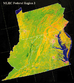
MLRC image of Chesapeake Bay Watershed conducted by Federal and State Consortium. Lessons from the Front
All this promise, however, must overcome sobering feedback from our first generation remote sensing advocates. According to a 1998 report by Warnecke, et al, despite the demonstrable cost and technical advantages of remote sensing for a variety of government information and decision support needs, most of the nation's local, state, and regional government officials are either not sufficiently aware of or knowledgeable about remote sensing to make informed decisions. According to Carlson and Associates, the majority of the nation's 30,000 planners are unaware, indifferent, or even skeptical regarding satellite-based remote sensing's capacity and potential for analyzing land cover as a societal planning tool.
Education, therefore, remains a consistent theme for advancing awareness and overcoming indifference. Those fostering remote sensing data and information use for improved governance must also address the impediments derived from the absence of a coherent national data access and pricing policy. Within the milieu of controversial, complex, and challenging issues, members of the community of government, university, and industry advocates are attempting to achieve remote sensing's promise through increasingly customized education, outreach, and demonstration programs. NASA's ESE has recognized the importance of maintaining outreach and support for these programs through a specific and comprehensive applications strategy that integrates applications, commercialization, and education in tandem with EOS science and technology advances and discoveries. Local, state, and regional governing and planning communities are developing promising experiences and ongoing programs that utilize satellite remote sensing. Remote Sensing Applications
Regional
There has been an increasing awareness by regional planners and resource managers of the inadequacies associated with site-oriented analysis in the face of habitat changes at the landscape and global scales. Regional planning often entails a mix of officials from states, territories, and numerous federal agencies dealing with cross-jurisdictional issues. Both Earth's systems and its ecosystems cross political and jurisdictional boundaries; modern planning and management approaches take this into consideration. Applying hierarchical approaches to planning under this recently evolved resource management doctrine entails the use of boundaries more reflective of species, natural communities, and hydrological boundaries well suited to ESE sensor capabilities.
Regional remote sensing applications have been exemplified by such programs as the Gap Analysis Program, the NOAA Coastal Change Analysis Program, and the Chesapeake Bay Program where issues focus on habitat fragmentation and biodiversity, land cover dynamics and hydrology, and human land-use impacts on the watersheds and airsheds. Disaster response, transportation, and farmland loss and protection also represent regional applications where the state and federal cooperatives are engaging current sensor data and information to support decision-making and policy development as a result of measurements delineating the scope and magnitude of these issues. New sensors can be expected to contribute significantly to regional agencies' ability to study and model large-area management topics for air, land cover, and water resources. 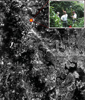
A DOQQ is draped over DEMs, exemplifying one application of remotely sensed imagery for Baltimore County's Lyme Disease incident location program. The map shows an area which is adjacent to Lockraven Reservior. State
Regional planning commissions, as well as state agencies and departments, operate at the state level on a variety of land-use management, base mapping, environmental protection, emergency management, transportation and utility corridor planning, and economic development programs. By the late 1990s, approximately one-third of the states have made extensive use of satellite data, one-third have experimented to a limited degree with mostly demonstration projects for remote sensing applications, and one-third have extremely low awareness or use of the technologies. For the most experienced states, the leading uses of remotely sensed satellite data, in ranked order, include: land cover/land use inventories (e.g., forests, wetlands), water resources, forestry, wildlife management, land planning or economic development, emergency management (e.g., earthquakes, wildfires), highway and utility corridor planning, agriculture, air quality monitoring, coastal resources management, environmental protection monitoring and regulation, energy management, revenue generation, geology, archaeology, and education.
This experience is limited to AVHRR, Landsat, SPOT, and other operational sensor systems. The next few years will bring a significant increase in available systems for such applications. Feedback from the states indicates that improvements in spatial, as well as temporal resolution of sensors will lead to greater use of the technology in their operations. State representatives have also indicated that improvements in the delivery mechanisms for remote sensing data, along with improvements in compatibility of these data with hydrologic, atmospheric, and change-detection software models (often embedded in GIS programs), will be needed. All of these enhancements are believed to be needed to foster expanded use in emerging applications market for states. Advanced research activities with sensors such as Advanced Visible-InfraRed Imaging Spectrometer (AVIRIS) are demonstrating new uses of remotely sensed data in foliar analysis, pollution detection, and brown-field analysis. These data can be useful as precursors to the predictive models for habitat stress, heat islands, hydrologic and stormwater runoff, and urban growth. Local
Growth in the use of geographic information at city and county levels has increased rapidly in the last decade due to the successful diffusion of GIS technology by vendors. Use of aerial photos has given way, in part, to the adoption of digital orthophotos for approximately half of the local jurisdictions surveyed by American Forests. This trend towards integration of remote sensing (digital orthophotos) and GIS for planning and other municipal operations bodes well for the successful introduction of high-resolution satellite data from commercial satellite companies in the future. Limited success with Russian SPIN-2 and Indian IRS data demonstrates this potential. Satellite data at resolutions of 1-3 meters provided at reasonable cost can be expected to find application in local government issues such as reservoir protection, forest fragmentation impacts, hydrology impacts from impervious surfaces, urban growth rates, heat-island effects, and human health impacts from disease vectors. With adequate improvements in geoinformation infrastructure and training programs, as currently being developed by organizations such as the National Association of Counties (NACo), the potential exists for significant use of ASTER, MODIS, and Landsat data for the more than 80,000 units of local government. Continuity and Expansion
It can be argued that significant progress has been made in the past 25 years for the application of remote sensing technologies in local, state, and regional government and planning activities. However, it can be equally demonstrated that the majority of government agencies at all levels of the hierarchy have yet to embrace remote sensing's potential in the decision making processes that include the allocation of resources for data, technology infrastructure, and training. Remote sensing's growth has been quasi-linear for most of the 1990s. To reach its full potential, we must build upon the solid foundation of applied results from the advanced state and local users and begin customized development in both vertical and horizontal markets from these foundations.
Each state will need to advance education programs for systemic use of remote sensing modeled after programs such as the Mississippi Space Commerce Initiative. Commercial companies will need to expand their base through cooperatives and commercial incentive programs such as the Commercial Remote Sensing Program. And regional consortiums will need to offer an array of customized applications and demonstrations by harnessing the technical and entrepreneurial resources of existing NASA sponsored remote sensing centers such as Earth Science Investigation Partnerships (ESIPs), Regional Earth Science Application Centers (RESACs), and Regional Application Centers (RACs). Finally, as defined by Federal Geographic Data Committee, National State Geographic Information Council (NSGIC), NACo, and other national surveys, the issue of equitable and comprehensive data access and purchasing policies is mandatory for promoting the extensive use of remote sensing and geospatial information throughout this country's government, business, education, and citizen organizations. These are the challenges that face those tasked with pioneering and promoting remote sensing technology into our nation's daily business agenda. Acknowledgment
Support for the research that led to this article includes NASA grants NAG5-4254-1 and NAG5-6514-3, NSF LTER grant DEB97114835, and EPA-NSF grant GAD R825792 About the Author:
Dr. Timothy W. Foresman is director of the Spatial Analysis Laboratory, University of Maryland, Baltimore County. Back |

