| ESE Data in Network and Local News for Weathercasts
By Dave Jones Earth. We see images of our planet when we go to museums, science centers, libraries, and even when we catch a television program on cable that deals with nature and/or science. There is one broadcast venue, however, where you can see Earth science data several times each day-your local newscast. More specifically, the local weathercast provides millions of Americans with the latest views from space and the most frequent exposure to Earth science data and observations of any public source today. Research in the news industry overwhelmingly pegs the local weather forecast as the single most important part of the newscast. It is the number one reason that most Americans watch local news.
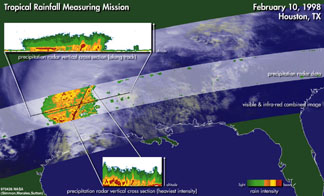 This image was taken on 10 February 1998 by the TRMM. The image shows the interior or intensity of a major storm over Houston, Texas. This image was taken on 10 February 1998 by the TRMM. The image shows the interior or intensity of a major storm over Houston, Texas. As technology becomes more sophisticated, so too does our ability to present the latest information from space. Data streaming down from satellites to ground stations will be processed efficiently enough to reach value-added resellers (VARs) in a timely fashion. Media partnerships with NASA are raising the bar for the standard of television weathercasts and introducing new data types to the American people. These are exciting times. As more remote sensing platforms are launched into space, a whole new world is opened up. For the first time, television meteorologists can take advantage of these platforms and present new and different perspectives, never before available.
The recent bout with El Nio not only proved to be an excellent example of the advances in science, satellite observations, and numerical forecasting, but it also allowed many Television meteorologists across the nation and the world to use wonderful visualizations generated by NASA, NOAA, and other organizations from satellite platforms. These advancements and visualizations warned us many months in advance of El Nio and assisted with the assessment of the impacts.
We will use Landsat imagery routinely to identify stresses in crops and identify rapid changes in coastal zones which may put communities at an even higher risk. Technology allows us to compare old images with new images and show our communities how our planet is changing. This may be done today, but not operationally by scientists in the weather department. Higher resolution data will lead to better observation and understanding of our environment and will be readily available to the television meteorologist.
Soon, the television weathercast will consist of very accurate 3 to 5 day forecasts, in addition to an explanation of today's weather. In addition, other forms of remote sensing data will be used to geographically orient our viewers anywhere in the world. Low Earth orbiting satellites will identify the best areas to fish and swim this weekend, and other types of remote sensing data will provide the television meteorologist with the tools to convey severe weather information such as the vulnerability of communities and impacts of severe weather events.
Today, many people do not evacuate coastal communities because they do not believe that their area will flood or that their house is in danger of sustaining damage due to high winds. The bottom line is that if the homeowner can not see what might happen in a storm or flood situation, they will stay and potentially risk their life. High resolution visualizations using ESE data as a basemap while adding digital elevation models (DEMs) and computer simulations can actually save lives by communicating the threat better than most meteorologists do today.
In partnership with other government agencies, NASA's ESE will forever change the way in which television weather and news is presented as we enter the 21st century. As more private industries work closely with NASA and other government agencies, new innovations will lead us down the road of increased science content in newscasts because our very lives will depend on it. Newscasts will no longer be "reports" on what happened, but will develop into sources of information that are critical to our daily planning, both in the long and the short term.
More and more, television stations are hiring meteorologists and scientists that study the Earth's atmosphere and predict its movement. Competition between stations is intense and the distinguishing features that a meteorologist can offer during his or her weathercast include technology and personality. Stations look for technology that takes very complex information and visualizes it in a simple, easy to understand manner. Meteorologists' personalities must be accepted by the community and cannot be enhanced by technology. As we move into the next century, more television stations will employ remote sensing specialists to take advantage of the many sources of data and to add value to new data delivered from satellite platforms. How quickly meteorologists can process data from satellites and generate products that can be used on television will be of utmost importance. In addition, the processing must be accurate and the product easily understood. No longer will these satellites be used for just research. The American people deserve to know how these satellite sensors can help them each and every day. Using this data and their resulting information products during the television weathercast will make this a daily occurrence. Of course, data validation is always critical.
For years, the only way to observe our planet using satellites has been through the series of satellites known as GOES and POES. GOES (geo-stationary satellites) provide every television station with daily images that can be looped to show the motion of clouds, weather systems, hurricanes, and typhoons. The GOES series of satellites has proven to be one of the most important tools meteorologists have in their arsenal of technology. POES is simply the Polar Orbiting Environmental Satellites. These satellites provide global data to NOAA's short- and long-range weather forecasting models. Other critical tools to the meteorologist are the network of Doppler radars and automated surface observing systems, including the lightning detection network and the astonishing improvements upon numerical weather prediction that have been made. Soon, every local television station will be running their own small-scale weather forecast model. Soon, weather forecast models will be able to predict the weather in your backyard with increasing accuracy. This model output will likely be displayed over high resolution basemaps, also derived from one of these new ESE platforms.
As meteorologists, climatologists, and other scientists study the Earth and our impact on its dynamics, our vision of what is happening will become more clearly understood and our responses more focused. The information generated by ESE observational satellite systems will give us more pictures to share with the world on a daily basis. It is easy to imagine future specialized cable channels dedicated to such specific market sectors, interests, and themes as deforestation, forestry, agriculture, and the visual literacy of the Earth.
The old saying, "a picture is worth a thousand words" works well with ESE data. The exciting thing is that using high resolution satellite data, new sensors and advanced visualization technologies on local newscasts has a multiplier effect by stimulating further interest and creative new ideas in the public. About the Author:
Dave Jones is a meteorologist at NBC owned WRC-TV in Washington, D.C. He was instrumental in establishing the Internet at WRC-TV in 1994 when he proposed successfully to NASA on innovative ways to increase public awareness of earth and space science data via the Internet. Now, the most-visited local weather web-site, WeatherNet4, (wxnet4.nbc4.com) now averages 3-4 million page views each month and includes many original real-time weather displays and tons of information on earth and space science. He is the principal investigator on three NASA cooperative agreements and is the weekend meteorologist for NEWS4 at 6 & 11pm. He was also recently presented with FEMA's Project Impact Outstanding Media Individual Award for his work to create more disaster resistant communities with the help of remote sensing data and for developing a model for other television stations to implement. Back |

