| The Thorny Problem of LIDAR Specifications
By Robert Fowler When deciding to contract LIDAR, many people have concerns because there appear to be no legitimized specifications written to address this technology. This is not totally the case. FEMA has drafted specifications, but they seem to defy compliance unless one bulldozes the area to remove the vegetation. Meanwhile, the American Society of Photogrammetry and Remote Sensing (ASPRS) has a LIDAR committee looking into drafting wide-ranging specifications. These specs may take some time to create, as there are a large number of stakeholders. In the interim, this organization plans to simply issue guidelines.
There are a number of ways to look at this subject. To produce specifications that are fully conversant with the various technologies already on the market, a specification for each type of laser system is required.
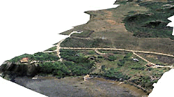
This is a color aerial photograph which has been draped over a LIDAR DTM, shown in perspective view. Accuracy of the orthorectification is based on the LIDAR point spacing, which is typically closer than DTM data captured from photogrammetric methods.
To understand the complexities of this issue, it is necessary to consider the fact that LIDAR systems are three independent bits of technology cobbled together by different manufacturers, in slightly different ways and with different types of components.
There is the basic airborne GPS (Global Positioning System) that is offered by several different manufacturers. One might assume that, with today's state of the art, all these systems work in the very same way. In theory, they do. However, not all deal with timing issues in exactly the same manner, and they use different software to process the satellite data before outputting it into coordinates one can use. As a result, there are small differences in how each collects and processes the timing issue. On the ground, at a stationary control point, this makes very little difference. In a kinematic mode, in a slow-moving vehicle, this also makes very little difference. However, in an aircraft flying along at 60 meters a second or faster, a timing difference of a few hundredths of per second can make the difference of several meters in position.
The second piece of equipment is the inertial measurement unit (IMU). These devices come from a variety of manufacturers as well, with differing qualities among them. Therefore, depending upon how much one is willing to pay, the IMU will be either more or less accurate in determining the position and the angles it measures, all of which are critical functions tied to a high-precision clock. To give an idea of the variety, one can pay anywhere from a few thousand dollars for one IMU up to a million dollars or more for another. Optech, one of the major LIDAR manufacturers, uses a system that is worth close to a quarter of a million dollars. It is reasonable to assume that, if a system proposed by someone else employed an IMU costing $25,000, it is unlikely to have the reliability, repeatability, response time and accuracy of a system ten times its cost.
Finally, we have the laser unit itself. There is a tremendous breadth of lasers, many of which are manufactured for uses that range from medical scalpels to steel-cutting torches. Surprisingly there are a great many measurement lasers and scanning lasers on the market. These send out a series of light pulses - usually at the infrared end of the spectrum - that hit an object, and a light-sensing device receives the return echo. Scanning lasers also come in several different varieties.
The light emitting diode that provides the light source is somewhat like a standard light bulb. Swinging it side-to-side many times per second would shake the LED to bits in short order. Therefore, many scanning lasers swing a mirror back and forth instead, directing the laser beam through a swath from left to right. Most airborne laser scanners use a moving mirror to enable their scan. The disadvantage of this system is in the mechanical aspect of having a high-speed device swing back and forth. As the mirror reaches the end of its swing, it slows down perceptibly before stopping, reverses direction, and builds up speed once again for the return trip. Because the mirror is swinging many times per second, all this slowing down and speeding up - calculated in microseconds -alters the potential accuracy of the pointing.
In theory there is a way around this effect. Manufacturers can use a rotating prism that turns just in one direction. As a result, the speed at which the prism is rotating can be kept constant. In fact, some manufacturers of scanning LIDARs use this type of technology. The disadvantage of the prism method is in timing the precise angles of the swath being collected. There is no fixed-angle stop position to correlate to a time signal. Another disadvantage is that all of the data are collected in one direction. If any biases exist in the measurements, they will never show up except through a field check.
There are good arguments on both sides of the fence. However, most experts believe that the mirror-type system, despite its drawbacks, does produce a more accurate result. The way to get around the slowing down and speeding up is via the software, and also by ignoring the data that is collected at the very end of each swath. Most LIDAR providers do exactly that, which is why they report to collect a swath 3000 feet wide, but then use only the central 2500 feet.
So we have three bits of equipment, each doing its own thing, collecting data that are tied to high-precision clocks. LIDAR manufacturers must ensure that the data collected by all three systems is in sync. They have to be able to calculate the position of the GPS and the IMU for each pulse of light from the laser.
This is where the second timing problem comes into play. Most airborne GPS units capture position in one-second epochs; that is, they record a location using four or more satellite signals every single second. However, as was stated earlier, an aircraft flying at 130 miles an hour is traveling close to 200 feet per second. During this time, the laser scanner is going back and forth quite a bit. Likewise for the IMU data, the all-important attitude, or else the angles-off-vertical the aircraft is in at any one point, are typically recorded every half- or one second. This means that positions and angles are interpolated for every single laser pulse at any one instant in time.
If this sounds pretty convoluted, it is - yet it isn't. There is a lot going on while the LIDAR is working but, broken down into smaller components, manufacturers can develop software to calculate all of the information needed - including the slowing down and speeding up of the mirror - to produce the correct answer.
At this point the reader may ask, "So what?" But if one is going to determine true LIDAR specifications, most of this information is important because it materially affects how good a result can be achieved from any particular model, at any given elevation above ground level.
Of course, it doesn't all end here. Let us assume we have collected information from a system that is airborne. What is really important is to be certain that the airborne system's frame of reference is the same as the frame of reference on the ground.
A whole new dimension is brought into play, if the reader will pardon the pun. And again, it is not as simple as it sounds. The first item under consideration is the GPS unit. To ensure that the airborne GPS unit is working within the same coordinates as is the client on the ground - and the whole purpose of this effort is to produce ground information - one needs to establish a common reference point. This is achieved by using a second GPS as a ground station, operating at the same time and using the same satellites as is the airborne system. Because of satellite configuration and features on the ground that might get in the way of satellite signals - including trees or tall buildings - most LIDAR operators place the ground station within the project's physical boundaries. If the project is large, then a ground station every twenty miles might be needed for high-accuracy surveys.
The reason for this should be obvious. As satellites continue their orbit, some drop out of view as new ones appear above the horizon. The operator in the air wants to be sure he is receiving signals from the same five or six satellites that the ground station is "seeing." Otherwise the translocation solution will not be as robust. If the ground station is a long distance from the aircraft, the chances are very good it will not be receiving all of the same satellites.
Second, there is that pesky problem of the shape of our planet. Satellites are in orbit based upon the center of mass of the Earth. Unfortunately, this is not the true center of the Earth's shape. Not only that, but the Earth is not the regular shape it appears to be on map projections. So there are differences within the "perfect" orbit of the satellite, the "perfect" shape of the Earth for whatever projection one is using, and the real hard ground one might be standing on. This results in what experts call a geoid/spheroid separation - where the geoid is the real shape of the ground, and the spheroid is its theoretical shape, such as in a map projection. If one cares to think about it this way, the orbits of the satellites are based on another spheroid totally disconnected from the other two! This separation can vary measurably over distances that are as close as forty or fifty miles apart. This is why ground control units must be spaced fairly close together in order to produce a highly accurate survey.
There are other fundamental effects that occur with airborne GPS surveys, resulting in some sort of shift. Speculation abounds as to its cause, but atmospheric conditions do cause bends in radio signals. These cannot be determined except by having ground stations use the same satellites as do the airborne system on the project site. The reasoning behind this is rather simple. Any distortion that affects the airborne system would also affect the ground system, and to the same degree. As the ground and airborne systems are closer to each other than they are to the satellites, corrections can be applied that effectively cancel out these errors.
But there's more. Now that we assume the ground/airborne GPS problems have been sorted out, there is still the IMU to consider. How does one know that the laser unit is sitting in an absolutely vertical position?
The simple answer here is to bench test the bolted-down equipment. But one can claim that bench testing a system, compared to running it several hundred meters up in the air, is an entirely different matter. This is obviously a correct supposition. So, once a ground-based calibration has been completed, a test area is needed where the position of the ground features is precisely known. At that point the LIDAR can be flown over it to collect a data set. If the system is flown back over the site in the opposite direction, and next the flight lines are turned 90 degrees to do the back-and-forth test again, identical results on the test area should be forthcoming. If this is not done, and there is consistent variation among the four different flight directions, then this is most likely a bias that can be removed mathematically. If there are consistent vertical differences, these can be assumed to be a vertical bias and again removed mathematically. While this may sound a bit hit-and-miss, it really isn't. Every piece of electronic measuring equipment should be tested for biases against known baselines. That is essentially what is being done here. What technicians look for is consistency. However, if these results are inconsistent, then something is not working properly and more bench tests are essential.
Nearly all LIDAR service providers regularly test their system against a swath of ground data that has been extensively surveyed through alternative methodology.
So how can specifications be written that cover all these diverse characteristics and phenomena, yet not be limited to one unit or single unit type?
Let us put this specifications problem into proper context. When we buy a car, we don't ask the salesperson what tolerances were used when the engine was put together, or whether the paint is a specific formulation. We ask the sales person about things that truly interest us. "Is this car from a recognized manufacturer that I can trust? Will it do the things I want it to do? How many miles per gallon does it get? Will it be delivered when I want it?" And, most importantly, "Does it fit my budget?"
When we think of LIDAR specifications, the same sorts of real questions need to be asked, summed up as in, "What do I, the customer, actually want?"
In the case of LIDAR, these answers must relate to the quantity and quality of data. The follow-up questions become, "How accurate do I want my data to be?" and, "How much data do I want?"
Let us first consider the latter point: the volume of data. This answer will depend very much upon the use of the data. One thing that surprises nearly every new LIDAR customer is the volume of data that is generated. Realizing one is being provided a point every ten feet means being given about 279,000 points per square mile.
This doesn't sound too bad, but don't forget that each of those points could be composed of eleven digits plus one decimal point northerly, ten digits and a decimal point easterly, and probably seven digits and a decimal point of elevation. That's a lot of bytes of data! Raw data files from the LIDAR unit are even larger.
Then there are more rhetorical questions. "As a client, do I really need the first, last and intermediate returns?" LIDAR manufacturers make much of these elements, and there are legitimate uses for them, but the average client probably doesn't need them. In open areas, the first thing the LIDAR beam hits is the ground. It is therefore simultaneously the first and last return. Likewise, if the beam hits a building, the first and last returns are synonymous.
If the beam hits a tree, then depending on the system and the size of the beam and what specifically it hits - whether a single leaf, a twig, a branch, or the center of the trunk - it could register a first return, several returns from branches on the way down, and maybe a last return from the ground, if there is enough signal strength left by the time it gets there. Truthfully, there isn't much value in all these data unless one is a research forester. Furthermore, if the amount of data with one return seems like a lot, wait until the data files for multiple returns are delivered!
Let us assume one is not a researcher, in which case there are really only three types of client requirements for land-based LIDAR data. The first is if one is in the business of delivering wireless signals, and the exact placement of obstructions is important. In this case, the deliverables will likely be a first return from the top of the obstruction and a last return from the ground.
Another specific case for first and last returns could be for transmission lines. For this type of survey, though, what most operators do is fly the LIDAR for the ground data, narrow the beam so that there are more hits on the wires, and then fly the line a second time for the wires themselves. Typically the system is configured to given the last return for the ground on the first flight, and the first return for the wires on the second flight.
But, in 95 percent of these cases, the client's deliverable is simply the last return. So it might be wise, if one does not fall into either of these two categories, to simplify things by requesting a DTM delivered of the ground, and let the LIDAR operator do the rest. Typically, all LIDAR systems are developed with software that filters out irrelevant data.
As a client, I would want to be sure that my contracted company is not supplying me with fake data. Therefore I expect them to tell me what equipment they are using, how it has been calibrated, and how they will use it. I will probably want to know how large their spot is when it hits the ground. I will also want a full description of their quality-control procedures. Meanwhile, I will probably tell them that, if I contract them to deliver data accurate to one foot RMSE vertical and two feet RMSE horizontally, then I won't pay them unless I get it!
A client's specifications can be simplified by stating, in one's own words, what are the specific expectations. These might include:
• A company using a LIDAR made by a proven manufacturer
• A last return only, unless there exists a compelling reason to state otherwise
• Accuracy of some specific precision, both horizontally and vertically, in open hard-surfaced areas
• Proper ground control to support the above accuracy
• Data deliverables in terms of a specific quantity, including all collected data, data at a grid of ten feet, twenty feet or whatever.
In addition, one probably should ask for an explanation of the methodology, the contractor's method of quality control and ground truthing, its experience (how many years it has been doing this?), its staff (how long have they been doing this?), plus references.
Of some concern may be the contractor's ability to stay on the job, especially if it is a large project. However, any company that has laid out over $1 million to buy a LIDAR system probably has something positive going for it. As a footnote to that, though, because these are expensive systems to operate and maintain, it is reasonable to expect to pay some money in progressive milestones for services rendered.
If there are other components to the project and LIDAR is only a part of the project, don't be surprised if the chosen consultant employs a LIDAR subcontractor. Not many companies can afford the outlay for a bit of equipment that isn't going to work full time for them. There's no shame in this. After all, most of us don't keep an attorney on retainer; we hire one for the couple of times during our lives that we need one.
The thrust of this article is probably going to leave me open to haranguing by the techies of the industry. In response, I can say that there are definite advantages to having guidelines for LIDAR operators, as these are in the interests of the client - and these guidelines will come, such as those being prepared by ASPRS. Meanwhile, if the client gets the product that is asked for, and spot checks are conducted in open, hard surface areas to ensure everything is really what it is supposed to be, then everyone will be satisfied, and we can all go home happy. About the Author:
Robert Fowler is vice president of sales and marketing for Lasermap Image Plus/GPR, a LIDAR services provider. He may be reached via e-mail at [email protected]. Back |

