| Internet GIS Supports Environmental Impact Assessment in Northern Alberta
By Jill Hebb 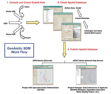
The project workflow: using GeoArctic SDM to create a geospatial database and associated Internet GIS project (Figure 2). The Project Coordination Challenge
An Environmental Impact Assessment (EIA) was carried out to determine the possible short- and long-term environmental effects of a proposed oil sands extraction project in northern Alberta, Canada. In this type of multi-disciplinary study it is often necessary for a number of agencies and consulting companies to collaborate, based upon their respective areas of expertise. In this instance, dozens of individual task leaders from different organizations determined when and where each step in the assessment process should take place, and the individual results were then integrated into the overall assessment.
GIS analysis and modeling is an essential component of the EIA process, as environmental resources are directly affected by changes in the shape and extent of the proposed disturbance. However, one of the main project coordination challenges is ensuring that all parties have access to the most current and accurate geospatial data and interpretations. Coordination of multi-disciplinary projects generally requires sending images or paper maps between offices, resulting in project delays as well as increased costs in both time and resources. The geospatial data and geographic extents are constantly changing. In an EIA, things are further complicated because analysis must be done in both local and regional scales. There are also various time-lines to consider, including baseline, impact, and reclamation scenarios, making the maintenance and organization of geospatial data both difficult and time-consuming. The Internet GIS Solution
The solution to the problem of coordinating such a large, multi-disciplinary study was to use a low-cost, highly secure Internet Map Server (IMS). Typically used for data brokering, Internet GIS has generally not been used in project management due to perceived cost, complexity, and time constraints. However, the use of a cost-efficient, easily deployable IMS allowed all of the geospatial data to be stored at a secure, central location where access to the project was available to everyone involved.
Each sub-contractor was able to view or analyze the most current geospatial data, as well as the associated metadata, through the project's web site. Using the Internet GIS applet, they could perform basic GIS functions such as adding and removing layers, ordering the layers on the map, toggling layers on and off, zooming, panning, identifying features, changing symbology, and printing map compilations. Shape files and geo-referenced images could also be downloaded onto the user's desktop GIS for further analysis, or local shape files and images could be added to the data for comparison and analysis in the Web applet.
In addition to saving time, the advantages of using an IMS to disseminate geospatial data were obvious. Data delivery was dynamic and timely, allowing the project team to manipulate and integrate the most current data layers. This provided team members with immediate access to a central geospatial database, allowing for more efficient quality control. There was also an issue of version control. In a rapidly evolving project such as an EIA, maintaining version control and data status information is essential. The IMS used for this project allowed the version and status information metadata to be automatically linked to each geospatial file. An additional advantage to the IMS approach was that the geospatial data was quickly viewed and manipulated in a common environment, with no unnecessary data conversion necessary to accommodate the numerous CAD and GIS applications used by the project participants. It also made the project data more accessible to non-traditional GIS users - such as project managers and administrators - who could use the system and the basic GIS functions with little training and no additional locally required software.
GeoArctic SDM was employed to develop and maintain the central project database of geospatial data and associated metadata, as well as to provide a suitable IMS solution to fulfill the project requirements. GeoArctic SDM is an integrated suite of tools that have been specifically developed to catalog, manage, and disseminate geospatial information for resource-based industries. The IMS module of the software provided an easily deployable and cost-effective way to deliver spatial information to multi-disciplinary project teams. GeoArctic SDM is scalable so that individuals, project teams, or entire organizations can use it as stand-alone software, or in conjunction with spatial data warehousing solutions. This makes it an ideal solution for use among a diverse project team ranging from individual consultants to large environmental and engineering consortiums, as it requires no specialized programming or database skills in order to catalog and organize the data, or to deploy a project on the Internet. Project Implementation
Figure 2 outlines the workflow necessary to create a project database with a desktop GIS such as ArcView, or for publishing on the Web. After compiling the data from various sources, the next step was to define the data model and required metadata fields, including those required for version control. Once the database was set up the geospatial data was catalogued, and input using the map-based interface and the associated metadata forms were further populated. A transaction log of all updates and changes to the database was automatically maintained. This element is especially useful when more than one person is involved. The final step was to publish the project database, at which time shape files were automatically compressed and associated legend files converted. It is further possible to encrypt published shape files.
The data model for this project was created in consultation with task leaders based upon their experience on similar EIA projects. A data model can easily be refined at any stage to accommodate changes in project requirements. A large part of the data modeling effort was to define the data categories and sub-categories that were used for efficient storage, search, and retrieval. At the data modeling stage a decision can also be made to store all the geospatial data in one project database, or else divide the data into separate project databases. Separate databases can be determined by geographic extent, project usage, the temporal nature of the data (baseline, impact, and reclamation scenarios), or accessibility and security constraints. Assuming access to the data is permitted, users can seamlessly retrieve and view data from each project database. User-defined metadata fields were created to track data source, version, and ownership information. As an alternative, metadata entry forms available in the software could have been selected to implement metadata compliant with Federal Geographic Data Committee (FGDC) standards. Cataloguing and input of the geospatial data was undertaken by the sub-contractors responsible for managing the GIS component of the project and for maintaining the project IMS.
Since the performance of an Internet GIS solution is dependent upon the speed of a user's network connection and the amount of memory used to run the application, shape files were compressed for transfer. In order to maximize the efficiency of the system, all shape files used for the project were first compressed to 25 percent of their original size, with no consequent loss of data. This resulted in a large savings in bandwidth that was beneficial to the overall performance of the application. Internet Security
It was necessary for the project web site to be highly secure, as the location and plans for the project had to remain confidential. Also, within each organization, access to the project web site had to be restricted only to those consultants working on the EIA.
Because of the confidential nature of the data, there were three levels of security used for this project. The first was a project-level username and password that served to redirect the user to the project web site. The next was a username and password that served to restrict use of the IMS application to authorized users. The third protected access to the actual data. While the vector spatial data used were originally in shape file format, they were encrypted to the web site URL before becoming web-enabled. Shape file encryption allowed the shape files to be viewed only via access to an authorized site. This meant that even if an unauthorized individual obtained the data and a copy of the Internet GIS applet, the data would be unreadable. With the appropriate password permissions however, end-users were able to download the data they required in an uncompressed and unencrypted format. Conclusions
The resultant solution was a cost-efficient highly secure IMS project management system. Maintaining the geospatial data in a centralized database eliminated the problem of each consultant having a different version of the various project layers. Task leaders also found that this system gave them more control and flexibility in the presentation and appearance of their maps. Different layer combinations or symbols could be tested interactively to determine which added the greatest amount of benefit to their share of the project. The bottom line was that a more efficient workflow resulted in savings of both time and money. About the Author:
Jill Hebb is a senior GIS analyst at GeoArctic International Services Ltd., Calgary, Alberta, Canada. She has worked in the GIS field for 10 years, with specialization in the application of GIS technology to the oil and gas industry, and in environmental disciplines such as forestry and habitat suitability modeling. She may be contacted via e-mail at [email protected]. Back |

