
|
 |
|
Flood
Plain Contract Results in New Software Development
Lasermap Image Plus/GPR has been in the Lidar business for quite a long time. Over the years the company has completed a number of large flood-plain mapping projects. In 2001 it won two major projects that required a great deal of data processing. The first was a flood-risk analysis of the shorelines of the St. Lawrence River. The second was a study of areas prone to flooding along the 165 rivers scattered throughout the province of Québec, Canada. Not only was this latter contract one of the largest ever awarded, it was also the first of its kind and therefore required the development of special software. Québec is Canada’s largest province, approximately twice the size of Texas and nearly as big as Alaska. In this part of the world, blocks of ice can dam up rivers and hold back the heavy spring runoff to cause severe flooding. Several years ago, scenes of the River Saguenay overrunning its banks were broadcast around the world. Especially newsworthy was the photo of a house sitting alone, surrounded by a raging torrent of floodwater. As with most flooding this particular situation was the result of an unusual weather event, in this case the extremely heavy rains of early summer 1996. Water drained rapidly into swollen rivers upstream of the Saguenay fjord, with disastrous results. Floods occurred along many of the province’s rivers, but it was the dramatic image of this house on the Saguenay that caught the attention of the world’s media. Following these floods, the Québec government elected to study the province’s most likely flood zones so that the effects of rising water in these areas could be mitigated, or at the very least used to give nearby residents an early warning. "[The government] pre-selected areas along the 165 rivers where there is likely to be significant impact on the local population," said Guy Beliveau, who consulted with provincial departments on Lasermap’s ability to provide timely and accurate surveys for this study. "The problem is," he added, "flood zones tend to be flat, which is obviously why they flood, but these areas are not necessarily totally flat. There are undulations that create unique situations and conditions. This profile has a tremendous effect on the hydrological modeling of what really happens. The reason why Lidar is such an ideal way of studying flood plains is because the amount of data surveyed is gathered universally over the area flown. By comparison, field surveying usually results in the capture of transects at specific intervals across the study area. Also, photogrammetry tends to generalize the contour intervals and not provide data that lies in between. The reality is that Lidar can catch numerous small undulations often missed by other [surveying] methods. "Lidar, by the very essence of its nature, builds a comprehensive and complete digital terrain model on the basis of real, measured pointings at fairly regular intervals," said Beliveau. "There were several unique aspects to this project," added Pierre Bélanger, Lasermap’s general manager. "Initially, the biggest element for us was logistics. These 165 rivers are spread across the entire province, and we had segments that needed surveying literally from one end of the province to the other. The first thing we had to do was put in place a massive logistical plan." The province was broken into seven areas, extending from Gaspé in the east to the Outaouais in the west, and from Abitibi in the north to the U.S. border in the south. Each area was then reviewed from the point of view of optimal data acquisition. This was done to reduce ferry times for the aircraft and also allow creation of a logical plan whereby field crews could provide quality control and base station GPS surveys. In order to provide optimal penetration of the Lidar signal to the ground, the Québec government requested that, whenever possible, the airborne Lidar surveys be conducted during snow-free, leaf-off conditions. Acquisition seasons were determined to be spring and fall 2001, and spring 2002, thus significantly collapsing the real time available to do the acquisition. "Typically," said Bélanger, "the time between snow- and leaf-free conditions can be as short as three weeks in the spring, and sometimes even less in the fall. Last year (2001) we were both lucky and unlucky. Poor flying weather in the spring meant that leaves started to come out before our spring program was completed. However, fall was relatively mild and we were able to catch up and survey from the time the leaves came down until the middle of December. Some years we have snow as early as mid-October!" A few of the flood plain areas were relatively small – only a few kilometers long – while others were extensive. There were times when multiple ground crews had to be mobilized to ensure that ground stations were operating at different locations, so that the aircraft was not held up while a single crew was moved to the next site. Lasermap has a distinct advantage in this respect. The company is owned by GPR Consultants that, in addition to having a small GIS and mapping wing, works in construction and on legal surveys in Québec. The workforce of 60-plus surveyors and support crewmembers was easily able to service the airborne acquisition part of the process. Massive quantities of data were gathered in the study of these flood plains, presenting Lasermap with its second major problem: processing the data so as to offer a hydrologic model with maximum accuracy. One of the major problems facing every Lidar operator is the processing of data to remove the effects of vegetation. This is relatively straightforward where there are large vertical variations in data pointing. Tops of trees show remarkably well in the point cloud, with visualization software clearly showing them for what they are. Intermediate levels of vegetation, bush or scrub are easily identified through the algorithms that come with most Lidar analysis systems. In many flood plain areas, however, there is a lot of undulating ground that rises and falls within a range of one to two feet. These data points become mixed with returns from low-level, often quite dense ground-cover vegetation. At this height (from 15 to 50 centimeters, or from six to 24 inches), the Lidar technician is faced with what might be described as "noise in the data set." This situation produces a quandary for the processor. Ground that is covered with long grass, bullrushes or other noise-level vegetation can create a series of problems. If one sets the automated parameters to remove the grass and bullrushes, many of the small undulations are removed as well, thereby adding a level of inaccuracy to the results. With the Québec contract, Lasermap was faced with a situation that required significant intervention in the vegetation-removal phase of the project. Essentially it appeared that it would be necessary to review and interpret imagery combined with the elevation data sets. This would normally add thousands of hours to the processing tasks. On the other hand, if this wasn’t done, the only alternative was to set the parameters to remove the low-level vegetation, thereby removing all of the small ground features and essentially give the clients an improper surface model. One of the company’s scientists reviewed the situation and decided there might be a way to resolve most of these problems. The company’s technical staff developed new algorithms for use in the automation process. While Lasermap chooses not to disclose exactly how they devised and implemented this method, the process is based upon sophisticated comparisons of mass points with individual pointings. This new software also classifies points as either ground or vegetation and can remove vegetation in the noise-level category with remarkable consistency. While this process does not solve every problem related to automated vegetation recognition, the company has demonstrated that it can reduce the level of intervention by operators during the processing phase while creating a financial benefit as well. Most Lidar companies will tell you that automated processing works properly the vast majority of the time. They will also tell you that circumstances generally follow the old 80/20 rule, with 20 percent of the money spent to do 80 percent of the work. Unfortunately, the remaining 20 percent of the work requires adjustments by the processing technician – although some companies either simply ignore it or charge an additional fee – because this final processing step eats up 80 percent of the processing cost. Lasermap increased its automated processing capability in flood zones to the 99-percent level, achieving more than 99 percent reliability. The company also reduced operator intervention time by 80 to 90 percent and increased the true accuracy of their final product. While this Québec flood-plain project has not yet been completed (about two-thirds was delivered as of this writing), the client has conducted stringent quality-control tests in the field and is quite happy with the results. "I’m very pleased with what our staff achieved over the past year," said Bélanger. "When you are a small company, you have to continually innovate to stay ahead. But being privately owned gives us the flexibility to invest and invent without the restrictions of public shareholders looking for a three-month, bottom-line return. We don’t make a lot of noise about our achievements but, in our own quiet way, our reputation as one of the very best Lidar providers continues to grow." About the Author: |
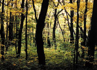 This
photo contains 60 percent leaf cover and allows good lidar penetration.
Photo courtesy of B. Theresa Aniskowicz.
This
photo contains 60 percent leaf cover and allows good lidar penetration.
Photo courtesy of B. Theresa Aniskowicz.