
|
 |
|
Iowa
DOT Boosts Efficiency with Online Imagery Catalog
No longer able to handle the large internal demand for locating digital map and image files from a fragmented archive, the GIS office of the Iowa Department of Transportation (IDOT) has developed a centralized, online Image Catalog accessible to personnel via the department’s intranet for finding and viewing spatial data. Nearly every division within IDOT uses surface visualization to conduct its respective tasks, especially those that involve corridor development and environmental assessment. In transportation applications, overlaying GIS base maps to provide additional information about various surface features enhances the value of the digital imagery. "Imagery is one of the cornerstones of our work," said Scott Marler, an IDOT ecologist. "Everything we do now is in GIS or CAD, so we need to be able to see the landscape. One of the most effective ways to view the landscape is through the use of aerial photographs." This combination of GIS data and digital imagery gives IDOT’s planners, designers, engineers and environmental consultants the initial land-use and terrain information they need to begin new transportation projects. It is also a key tool in conducting infrastructure inventory, improving road centerline accuracy, determining bridge locations, and complying with environmental regulations. IDOT sought a single digital environment where these and other spatial data sets could be searched, located and accessed. The department selected Intergraph’s GeoMedia suite of GIS products to build an organized data catalog for personnel to use when viewing data online, regardless of its source, projection or format. In addition to its online Image Catalog capability, GeoMedia software is used to create a Coordinated Transportation Analysis and Management System (CTAMS). This desktop system offers access to a variety of geospatial databases, and it will soon be enhanced to include a linear reference system where accident reports, pavement conditions and other written materials can be linked to road segments for advanced transportation analysis. A Cumbersome Process Over the past decade, Iowa has built an extensive archive of USGS Digital Orthorectified Quarter Quadrangles (DOQQs), Digital Topographic Quadrangle Maps, and individual county aerial image databases. The GIS office has historically maintained these files on approximately 400 compact disks, with files stored in different formats and separate coordinate systems. Until recently, searching for imagery at the IDOT headquarters campus in Ames meant a trip to the GIS office to enlist the support of the two-man staff in a hunt for data. The process involved searching through paper maps or GIS maps to find the area of interest, and then paging through several documents to pinpoint the correct CD that held the digital imagery. "My job often became that of a CD librarian," said GIS assistant coordinator Todd Noah. If the search was successful, the CD was signed out to the individual. But if others needed the same data, they were forced to wait until that disk was returned. Oftentimes, once the correct image was located, it was discovered that the digital images were in different formats. For some IDOT offices this was not a problem because they already used GeoMedia, which could handle the multiple formats. The designers and planners prefer MicroStation since most of the engineering applications run on top of that software, but many MicroStation users did not have access to software that could effectively use the imagery. The maps and images also were rarely in a common projection, which posed problems for superimposing layers on top of one another. If the imagery was not in the projection required by a particular group, the GIS office had to re-project it manually, which was a cumbersome process. The engineering offices employing MicroStation needed maps in a State Plane coordinate system, whereas most other divisions worked with a Lambert Conformal Conic projection. While access to data was one issue, letting personnel know it was available to them was quite another. Most people in IDOT were unaware of the archive, much less how to access it. The GIS office realized it needed a way for everyone to locate imagery quickly and easily on a specific project. This process had to be intuitive and furthermore allow them to use the data at their desktops. displaying it in the format and coordinate system required. In addition, IDOT wanted to provide as much metadata as possible to help users determine the appropriate use of the data. Metadata lets the user know when an aerial photograph was taken and how it was georeferenced. The Imagery Catalog A staged approach was taken to publishing the Imagery Catalog online. In 1999, the GIS office took the first step toward solving the archive problem by putting all of its spatial data into a single repository. Over a 12-month period, digital data was collected from many sources – including the CD library – and subsequently stored on an IBM database server. Imagery included DOQQs and digital topographic quad maps that covered the entire state, as well as aerial surveys flown by individual counties. These were all raster files. In addition, internal DOT road centerline and political boundary data in vector formats were assembled. So were several hydrologic and land surveys, supplied by the Iowa Department of Natural Resources in ArcView files. While storage consolidation reduced the search time for imagery, data dissemination remained a stumbling block. Staffers still needed help locating and accessing images, and reviewing the metadata. Todd Noah spent an average of two hours a day assisting DOT personnel in finding and using the imagery. The database, however, provided the starting point for developing the Imagery Catalog. Several IDOT offices were already using GeoMedia for desktop GIS, and it was decided to use this suite of software to build the catalog application. The GeoMedia suite fit well with system requirements since it is designed to integrate and maintain geospatial data from a diversity of file types, formats and map projections. This feature meant that IDOT personnel could access multiple files, overlay and view them without needing to convert them from their native formats. Eliminating file conversion saved a great deal of money for the project. GeoMedia also provided the environment necessary to create advanced GIS data analysis tools such as CTAMS. To date, IDOT has installed GeoMedia on a total of 60 desktop seats throughout several divisions. Part of the reason for selecting Intergraph’s GeoMedia suite of products was the GeoMedia WebMap software, which extended access to all IDOT personnel working on the local area network. Most users tap into the network from their offices on the Ames IDOT campus, but others are located at remote sites. GeoMedia WebMap allows anyone with access to the internal network and the ability to use a browser to search, to view, and to use the geospatial data. In building the online Imagery Catalog, the project team worked with Intergraph to develop a Web page with an intuitive graphical user interface (GUI), plus a Microsoft Access database that allows pointers to locate image file names. The Web GUI displays city and county boundaries, road and highway centerlines, rivers, and other key topographical features. To make the data more manageable for the server and for distribution over the LAN, IDOT used MrSid compression software from LizardTech. This software compressed most files from about 50MB down to around three or four megabytes each. Even at this rate of compression, image and map files stored on the IBM server require 200 gigabytes of disk space. For IDOT designers working in MicroStation, re-projecting map files from multiple coordinate systems and projections to State Plane coordinates is no longer a problem. Intergraph’s Image Analyst performed the automated re-projection of all necessary files during system development. These files can be located with GeoMedia WebMap and then loaded directly into MicroStation applications. Development of the entire desktop and online system took only three months in early 2000. One-Stop Shopping To get a preliminary look at the imagery available for a given project, users simply click on an image outline in the immediate project area. A pointer locates the image on the IBM server, and GeoMedia WebMap pulls it up and displays it in its native format. If the image name is already known, users can access the file in GeoMedia or MicroStation. Another way to search a project area for imagery is through the information that pops up as the cursor moves across a map feature. This makes things easier for the user to locate, or browse, for imagery. "This is an intuitive system," said Noah. "It was developed so anyone in the department can use it." According to Noah, the number of requests to help locate specific images has dropped off dramatically since development of the online Imagery Catalog. "People know what’s available now; they don’t have to call in and ask for it. The catalog offers a one-stop location for finding and accessing that imagery." Searches that used to take an hour or more can now be accomplished in under 10 minutes. "The online Imagery Catalog," added Marler, "gives everyone the ability to look at their respective project areas and see that there might be a suite of images available." The proposed highway near Cedar Rapids is a good example. It had been in the planning stages for years, but no one knew whether or not imagery was available for the area. With the catalog, any authorized user can quickly see that DOQQs are already in the system and immediately available for planning the project. An Ongoing Project The Imagery Catalog is a never-ending project, and there will be continued incorporation and processing of data from the counties and from other sources. As the department flies road corridors for engineering purposes and captures photogrammetric features off the photos, these images will be included in the catalog. The department may also purchase one-meter-resolution IKONOS satellite imagery from Space Imaging to enhance the catalog. Functionality is another area that will be enhanced. More efficient database queries are needed to help IDOT personnel find imagery quicker, and to more closely integrate the Web environment with the other applications that use this imagery. GeoMedia WebMap is currently being used for the Image Catalog. The next step is to expand CTAMS into a Web application that can access a GeoData Library, where linear and polygonal data will be merged with many other informational databases. IDOT maintains extensive databases on vehicle crashes, traffic counts, environmental data, and road conditions, which will be valuable for automated decision support analysis and modeling of "what if" scenarios. The department’s goal is to create an environment where planners and engineers can easily integrate data using its location attributes. IDOT recently completed the data model for a new linear referencing system and expects to have its GeoMedia and GeoMedia WebMap interfaces with the GeoData Library up and running in two years’ time. About the Author: |
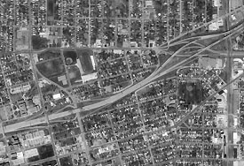 This
picture shows how CTAMS is used in GeoMedia to locate specific imagery
for display in a GIS analysis.
This
picture shows how CTAMS is used in GeoMedia to locate specific imagery
for display in a GIS analysis.