
|
 |
|
Using
Satellite Imagery to Map Military Bases of the Former Soviet Union Abstract In 1986, the Norwegian Institute of International Affairs (NUPI) used Landsat imagery to begin its first study of military bases in the former Soviet Union. Later, this initial study was expanded to include the use of SPOT images, and the area of interest was widened to cover the nuclear test sites situated on Novaya Zemlya. In the mid-1990s, a satellite study of the military bases in the Leningrad and Baltic areas was undertaken as well. The author of this article, a researcher at NUPI, initiated the first study in 1986 as well as following up all of the later studies mentioned above. During the last three to four years, NUPI has purchased a great many CORONA photographs of the former Soviet Union, areas previously studied by using Landsat and SPOT images. Enlargements of these CORONA photographs were used to revisit a selection of military bases and other key areas. In this first-person account, Mr. Skorve describes the history and process of this monumental effort.
Historical Background of the NUPI Studies At the Geographical Institute of Oslo University in the early 1980s, I used Landsat-MSS images to survey the geological structures of a large nickel and copper mining area just on the Russian side of the Norwegian-Soviet border. With respect to the infrastructure observed here, it was determined that the area was both mining and military in nature. The first cloud-free Landsat-TM images became available in 1985, and the improved resolution of these images gave us a better understanding of the grand scale of Soviet military activity on the Kola Peninsula. I searched for information on these Soviet bases, but very little was available. However, I saw that these Landsat images contained potential new information on the military bases on the Kola. At this point I contacted the Norwegian Institute of International Affairs (NUPI) – a think-tank on foreign policy and defense and the largest institute in its kind in the Nordic countries – and informed them about the potential value of Landsat image information in relation to the military portion of the Kola. At that time the director of NUPI was the late Dr. Johan Jorgen Holst, who soon thereafter joined the Norwegian Government to serve as its Secretary of Defense. He approved my proposal to start a small satellite project for the Kola Peninsula. Joining me in this study was NUPI security policy researcher Tomas Ries. He was well acquainted with the organization of the Soviet military on the Kola, having for several years collected open-source information on these military bases. I carried out image interpretation in close cooperation with Tomas Ries and several other NUPI researchers. We experienced many thrilling moments during the interpretation process when several large air and naval bases formerly unknown to us were discovered. The Kola report was finalized in August 1986. Because we did not expect much interest in our study, we printed only a limited number of copies for the ensuing press conference. Much to our surprise, we found the pressroom filled with TV cameras, journalists and photographers from many countries. But it was not until the next day, when we saw our report as the top story on the front page of the International Herald Tribune, that it became apparent to us that NUPI had achieved worldwide attention. In retrospect, we understand that our report had "cracked a vacuum bottle," replacing the void with information that had never before been made available to the public. Brassey’s Defence Publishers put out an updated and expanded version of this report in 1987. Cloud-free SPOT images of the Kola Peninsula became available in 1988, and the NATO-related Norwegian Atlantic Committee assigned me to make a new and more detailed study of the military environment on the Kola. Including a satellite-image atlas of the peninsula based on SPOT and Landsat images, this study was published in 1991. One year later, NUPI was invited to cooperate with the TRIC Center of Tokai University (Tokyo, Japan) in the field of strategic satellite remote sensing. For the past 12 years and in close cooperation with NUPI, TRIC has produced most of the high-quality digital satellite images used in our studies and projects. In 1989 and 1990, the Soviet Union signaled its intention to close down its nuclear weapons test site in Semipalatinsk. This caused great concern in the Nordic countries over the prospect of increased nuclear weapons testing activity on Novaya Zemlya because of its proximity to Norway, Finland and Sweden. We tried to find information on the nuclear test sites on Novaya Zemlya, but there was very little available. My proposal to the NUPI director involved making a satellite study of the northern test site on Novaya Zemlya. He agreed, and my close NUPI colleague John Kristen Skogan joined me on this project. During my subsequent stay at TRIC in Tokyo, my Japanese colleagues and I made high-quality satellite images for use in interpretation and analysis. This report was ready by 1992, and it contained new and valuable information on the test site itself and the activities there. The Royal Norwegian Ministry of Foreign Affairs handed out a copy of the report to each of the U.N. delegates present at the disarmament negotiations in Geneva, Switzerland. Several years later we learned that the Russian delegation showed great interest in our report. The Russian minister of energy, V.N. Mikhailov, appointed his chief scientific adviser to chair a commission of nuclear testing experts to evaluate the NUPI Novaya Zemlya report. This commission was surprised by how much information we had obtained by using commercial satellite imagery. They furthermore confirmed that most of our interpretations and analyses were correct. Their comments were both encouraging and valuable to us, as was their response to our questions related to the environmental safety of the nuclear test site. In 1994, I made a satellite study of the military bases in St. Petersburg (formerly Leningrad), the Baltics, and the Kaliningrad enclave. This study was done on assignment of the Swedish Foreign Policy Institute – NUPI’s sister institute in Stockholm, Sweden – and was a part of a comprehensive study funded by the Ford Foundation. NUPI was provided with the first CORONA photographs for interpretation and analysis in 1996. We first wanted to revisit areas in the former Soviet Union to improve our earlier interpretation, but also to map expansion and construction of new facilities by change detection. The use of CORONA photographs also aimed at giving us experience in the interpretation and analysis of high-resolution images from commercial satellites. The Geographical Setting of the Main Areas of Interest The Kola Peninsula To its west, the Kola Peninsula borders on Finland and northeastern Norway. Approximately 80 percent of its area lies north of the Arctic Circle. Most of the largest military bases and installations are concentrated to the northwestern part of the peninsula, from the Norwegian border and eastward. Its latitude corresponds to the northern half of Alaska. With respect to latitude, the row of naval bases along its northwestern coast corresponds closely to that of the Brooks Range in Alaska. The Kola Peninsula is climatically favored by the relatively warm Gulf Stream that moves up along the Norwegian coast. After passing the northern tip of Norway, this water mass turns southeastward along the Kola coast, which is why the coast and fjords of the Kola do not freeze up during the long winter. The ice-free harbors located here make the peninsula very important to the Russian navy. In the lower part of the peninsula, the terrain is free of snow during the summer season. On average, clouds obscure about 75 percent of the Kola satellite images. Novaya Zemlya The northern nuclear test site is situated in the middle part of Novaya Zemlya, on the southern coast of the Matoshkin Strait that divides the two Novaya Zemlya islands. It is situated between 73°N and 74°N, corresponding to a location somewhat further north than Point Barrow, the northernmost spot in Alaska. The lowland test area is snow-free some three months of the year, with August as the warmest month. The climate of Novaya Zemlya is also influenced by the Gulf Stream, but to a considerably lesser degree than with the Kola Peninsula. Novaya Zemlya is further east and somewhat further north, thus the Gulf Stream water is mixed with cooler water in the Barents Sea to the west of Novaya Zemlya. Eighty-five to 90 percent of the satellite images covering the test area are cloud-covered. With respect to satellite remote sensing, this is even a worse target than the Kola Peninsula. Military Bases on the Kola Peninsula Severomorsk Severomorsk is the headquarters of the Soviet northern fleet and lies about 30 kilometers north of the city of Murmansk. This city, the largest on Earth situated so far north, has a population of 400,000. On the northern side of the naval base, several long piers are arranged in a fan-shaped pattern. On Landsat and SPOT images we can see a number of navy vessels along the piers and in the harbor basin. Two major naval vessels in the basin are large enough to be identified by their shape and size. These include a 43,000-ton Kiev-class aircraft carrier at 274 meters long, and a 25,000-ton Kirov-class cruiser at 250 meters long. The outline of their superstructure makes them even easier to identify. The digitally merged, high-quality color combination of Landsat-TM and SPOT-P increases the possibility of improved interpretation. The CORONA photographs of the Severomorsk area were taken some 20 years earlier than the Landsat and SPOT images used in the previous study. However, the CORONA resolution is far better, approximately two to four meters, and therefore much more detail can be seen on these photographs. For example, the largest navy vessel in the Severomorsk basin on the CORONA photographs is easily identified as a cruiser of the Sverdlovsk class. By using Landsat and SPOT images in combination with CORONA photographs in a systematic change detection mode, it is possible to map exactly how Severomorsk developed and expanded. This is also the case for any site or area that has been observed by these satellites in similar fashion. Tsyp Navlok The small base of Tsyp Navlok is situated on Fisherman’s Peninsula, the northernmost part of Kola. It is located at the northeastern edge of this peninsula and faces the Barents Sea. The base is therefore well suited for observing and controlling the entrance of the long Kola fjord with Murmansk, Severomorsk, and many other towns and military bases. The units and buildings are small in Tsyp Navlok, and the geomorphology and landscape have produced a type of terrain that conceals them effectively. As a result, even good Landsat-TM images show very little of the base area. In strong contrast, the CORONA photographs of this same area exhibit many interesting details such as individual buildings and military barracks, narrow roads, a heliport, and SAM (surface-to-air missile) bases. Gremikha Gremikha is the easternmost major naval base on Kola. It was discovered on satellite images during the first NUPI study of Kola in 1985 and 1986. This base is situated more than 200 kilometers east of Murmansk in an area with a much colder climate than western Kola, since the effect of the Gulf Stream is weaker this far east. Germikha is thus close to the western border where the sea is permanently covered with ice during winter and spring. Gremikha is a submarine base. Even on Landsat-MSS images it is possible to see the dark lane behind surfaced submarines as they move northward into the Barents Sea through ice-slush, in the coastal area off Gremikha. The placement of elongated Besymyannyy Island effectively shelters the harbor from the rough Barents Sea. SPOT images show a rather large air defense site several kilometers east of Gremikha, along with another base that contains numerous buildings. The western passage into the Gremikha basin was intentionally made narrow and strictly controlled during the 1970s. This is one of many detailed conclusions we can draw from comparing Landsat and SPOT images with CORONA photographs. By using satellite imagery from 1960 to the present day, the Gremikha area seems especially suitable for a detailed study of the expansion of the base and its infrastructure. The Novaya Zemlya Nuclear Test Site During the NUPI satellite study of Novaya Zemlya, it became apparent that some important areas within the test site were constantly in shadow or very poorly illuminated by the sun. This is due to the following factors: very rough terrain, rather low solar altitude because of the extreme northern latitude, and the sun-synchronous orbit of the Landsat and SPOT satellites that restrict imaging to only around 10 a.m. local time. The mountain ridge that slopes down toward the Matochkin Strait keeps the coastal zone in perpetual shadow on Landsat and SPOT images. We know, however, that extensive tunneling activities took place here to bring the nuclear charges into the emplacement cavities under the mountain. We found underground explosion craters near the top of the mountain ridge on the Landsat and SPOT satellite images but, due to the shadow, no mined rock tailing piles or any infrastructure from these activities can be seen at the foot of the ridge. It was imagined that the heavy drilling equipment was first brought by vessel from the mainland to the harbor of the Severny base, situated somewhat further south of the tunneling sites. This equipment could then be transported along the coastal road northward to their final destination. A single CORONA photograph provided much new information about the activities in this area on Novaya Zemlya. This photo was taken one afternoon early in the summer of 1966. The western slope of the mountain ridge facing the Matochkin Strait was sunlit and we could therefore see a structure that strongly indicated tunneling activity. The Matochkin Strait was still covered with gray, rotten ice that obviously would break up and melt within the next few days. Thus nearly all of the original winter ice had disintegrated, but one very interesting observation could be made. The remaining, thin layer of ice still had imprinted upon it traces of activities that took place during the long winter season. The path of the icebreaker lane showed that vessels carrying heavy drilling equipment did not go to the Severny harbor, but instead continued further north to a point just off the Matochkin beach. The imprinted pattern on the ice clearly shows that the heavy equipment must have been hoisted from the vessels onto large trucks that drove across the thick ice on the Matochkin Strait, over the beach, and then onward to the tunnel entrances. Had the CORONA imaging been done some days later, all this information would have been lost with the melting of the ice. This same 1966 CORONA photo also shows that, in this area, a new base had been built to support the first phase of underground nuclear testing on Novaya Zemlya. About the Author: |
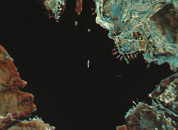 Severomorsk,
headquarters of the Russian northern fleet, located about 30km north of
the city of Murmansk. This is a small, enlarged section of an image that
is the result of digitally merged SPOT-P and Landsat-5 images, with resolutions
of 10 and 30 meters respectively. Clearly seen are several long piers
arranged in a fan-shaped pattern. The largest of the naval vessels in
the basin is easy to identify, by shape and size, as a 43,000-ton Kiev-class
aircraft carrier, 274 meters long. Digital image production by TRIC of
Tokai University, Japan.
Severomorsk,
headquarters of the Russian northern fleet, located about 30km north of
the city of Murmansk. This is a small, enlarged section of an image that
is the result of digitally merged SPOT-P and Landsat-5 images, with resolutions
of 10 and 30 meters respectively. Clearly seen are several long piers
arranged in a fan-shaped pattern. The largest of the naval vessels in
the basin is easy to identify, by shape and size, as a 43,000-ton Kiev-class
aircraft carrier, 274 meters long. Digital image production by TRIC of
Tokai University, Japan.