| Santa Clarita GIS Group Makes Things Happen in City Hall
By Christine Henry What would happen if a GIS group, nestled deep within a city's bureaucracy, started acting more like a private company? The results are readily apparent in the Southern California city of Santa Clarita, where the GIS team is taking an innovative approach by using operating principles generally seen only in private business.
 The GIS team encouraged the city's streets division to start using handheld devices in the field to capture storm drain maintenance data. The GIS team encouraged the city's streets division to start using handheld devices in the field to capture storm drain maintenance data. Surrounded by unincorporated Los Angeles County, Santa Clarita is one of the fastest growing cities in the area, with 20 annexations over the past 13 years. Led by visionary GIS team leader Belinda Perez, the four-person group of GIS experts considers it their mission to find solutions to the business problems of their clients, who are responsible for managing this rapidly growing municipality. This unusual team treats city staff like valued customers and is aggressively involved in marketing its services. "They don't wait for people to come to them," remarked Jeffrey Lambert, director of the Planning, Building and Safety Department, which oversees the GIS group.
Placing a strong emphasis on customer service, Perez meets regularly with different divisions within the city to demonstrate the latest applications the GIS team has developed, and what GIS technology can do for them. "We delve into their business so we can really understand it and deliver good, solid solutions, using technology as a tool," she said.
In a city like Santa Clarita, with its high level of development activity, it is important that members of the planning and engineering staffs have all the subdivision information right at their fingertips. "The GIS group came to us to find out what our needs were," said Enrique Diaz, associate planner. "They identified a business plan based on the services we provide to the public, the public's needs, and the city's own internal needs."
The team then created a plan to use GIS to improve overall service. For example, the interactive ArcIMS application the team developed allows city staff to view online the latest information on all development projects in the approval pipeline: all major subdivision and related zoning activity, with direct links to documents such as conditions of approval and scanned subdivision plans. This timesaving application has dramatically improved public counter service, as well as services to other city departments.
"Most people don't know what they want in terms of GIS, and Belinda's group helps them flush this out," Lambert said. This proactive approach is in direct contrast to what most cities do. GIS technicians usually wait for staff members to come to them requesting a GIS solution, and then give them what they ask for. Unfortunately, millions of dollars is often wasted on technology for technology's sake when the time is not taken to determine what the customer needs. Clearly Understand the Clients' Needs
To help her clients clearly understand their needs, Perez brings in Psomas, a Los Angeles-based consulting engineering firm. Experts in the Psomas re-engineering process act as facilitators, helping the GIS team acquire the information they need regarding their clients.
Based on interviews with city staff members, consultants from Psomas define workflow processes and functions to develop a business model that breaks down core functions. This visual approach is far more effective in highlighting problems than is a 20-page report. By actually mapping core business processes for each city division, the inefficiencies and opportunities for improvement become readily apparent.
In addition to helping the planning department track subdivision activity, Perez' team is also working to streamline the city's overall development process. The first step is to develop a clear understanding of this "business." Psomas consultants have charted the entire process of issuing development permits as it moves from department to department. In examining this function, Psomas has mapped out everything that is involved, including data capture, data flow, data automation, data transfer between departments, and reporting automation. Once the business functions have been laid out, Psomas consultants make recommendations as to which problems can be solved with a GIS solution.
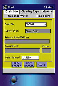
In the case of the city's streets division, and based upon findings by Psomas, the GIS team encouraged this division to begin using handheld devices in the field to capture storm drain maintenance data that fulfills National Pollutant Discharge Elimination System (NPDES) requirements.
Storm drain maintenance crews will soon use Compaq IPAQs to input storm drain locations, frequency of maintenance, type of debris, time required to clean the drains, and a full listing of which equipment is used. The collected data will be used not only to fulfill NPDES requirements, but also to enhance overall reporting to division management. This application was developed with an easy-to-use modular format that does not involve text scrolling. "It looks like we'll need just very basic training. If I can get the hang of it, anyone can!" said storm drain maintenance crew leader John Enriquez. Tailored Applications
Enriquez also related that the GIS team "went all-out to customize the application strictly for our reporting needs," by first talking with everyone from management and supervisors, to crews in the field.
Perez believes that customization is a key factor in customer service. Once the customer's needs have been analyzed, the GIS team creates a pilot application using ESRI's ArcIMS that, "...looks and feels exactly as the customer wants it; it's not an out-of-the-box application," she said.
Using ESRI's ArcIMS, the data is presented via a Web-based GIS that is designed for point-and-click operation, virtually eliminating the need for training. The team currently has in development a GIS application that will support the joint city/county general plan process. The team is developing a dynamic interactive system that allows the user to see exactly where and how growth is taking place, a program that was created to assist in planning the city's future infrastructure needs.
An application designed specifically for the planning/building/safety department retrieves building permit information for any existing building within the city. This permit information is called up by APN number, by address, by owner name, or by location. Using a parcel map to pinpoint the location, the user is immediately given the parcel number, a representation of the building footprint based upon aerial photographs, and all permit history. City official Ruben Barrera pointed out that the code enforcement division has found this application especially valuable. "They used to spend hours tracking down ownership information on a piece of property. It was all there in the system, but difficult to retrieve without the exact address," Barrera related. "Now all this varied information is in one place, and easily retrievable." Proactive Approach
When controversy surfaces at city hall, the GIS team does not wait to be approached. Perez immediately contacts city staff to show how GIS can help solve these problems. For example, Santa Clarita was strongly against the prospect of an aggregate mining company starting up operations on a site just outside city limits. Perez immediately went to the city manager to let him know how her team could help. According to planning director Lambert, the city needed to make its case to county officials quickly and concisely. The GIS team collected the relevant data and produced aerial and topographic maps for the city manager and planning department to use as tools as they navigated their way through the public controversy. One especially valuable exhibit showed current and pending development projects near the proposed mining site that clearly illustrated the site was not as remote as it first appeared. Aggressive Marketing
In addition to ferreting out the needs of her customers and tailoring applications to meet these needs, Perez' team aggressively markets its services. One of the biggest promotional events is the annual GIS Day, where four or five new GIS applications are showcased in a tradeshow-like atmosphere. At the GIS Day held in spring 2001, more than 160 city staffers (out of a total of 200 at city hall) wandered through a huge conference room that displayed many new GIS applications. A map gallery featured GIS exhibits, complete with user testimonials. To increase turnout, Perez convinced consultants to donate prizes such as movie tickets and free dinners.
In addition to the impressive turnout by Santa Clarita's city staff, representatives from several nearby cities and a local university also attended GIS Day. Attendees showed interest not only in these new GIS applications, but also in the team's unique marketing strategy.
One application to generate a great deal of excitement from other municipalities was the rapid report/rapid response application developed for the city's Emergency Operations Center (EOC). This application ties a Microsoft Access database to a mapping program that, in the event of an earthquake or other natural disaster, allows EOC personnel to electronically track incidents and map them for immediate response by fire, police and public works personnel.
Team of Experts While Perez directs this team and is responsible for strategic planning and marketing, Santa Clarita counts among its GIS team members a number of well-trained individuals. One is an expert in database development who uses Visual Basic and Access to develop custom data-capture applications. Another is an expert cartographer who is responsible for data integration and gathering all relevant line work. A third is an expert GIS analyst who uses ArcIMS to build custom applications for each customer.
There is an added bonus to this team's aggressive approach in marketing its services, according to Lambert. "Since they are out there meeting across all city departments," he said, "they are one of the few groups that actually knows what everyone in the city is up to; consequently, they help the city to integrate and put all the pieces together."
Perez added, "The bottom line is to look at the global perspective of the city's needs and make sure our GIS team is providing excellent service to solve all our customers' business problems. We may work for local government, but we act like a private business to make things happen."
About the Author:
Christine Henry is a writer who specializes in engineering, GIS and planning issues. Her firm, Henry Woodward Communications, is located in Manhattan Beach, Calif. Back |

