| Creating Bald Earth Models Beneath Dense Vegetation With Synthetic Aperture Radar
By Markus Rombach Aero-Sensing Radarsysteme GmbH is a private enterprise founded in early 1996 by scientists of the German Aerospace Research Establishment (DLR). Their know-how represents the latest in international radar technology. In particular, their application of radar interferometry, with a highly automated evaluation of the mission data, permits them to accurately determine surface heights and generate three-dimensional images of the Earth's land and water surfaces, independent of weather and light conditions or any kind of vegetation coverage. Ever since the development and construction of their first Synthetic Aperture Radar (SAR) system, the company has grown steadily and now runs four different radar systems worldwide, including those on its own as well as in third-party-owned airplanes
.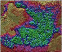 Figure 5: The difference between the two DEMs is illustrated by different colors. Figure 5: The difference between the two DEMs is illustrated by different colors. At the end of 2000, Aero-Sensing was busy mapping an area within Brazil's tropical rain forest, utilizing its newly manufactured multi-polarimetric and interferometric P-band sensor, plus the long-approved X-band system. This project was carried out as a collaborative effort among the Brazilian Army (DSG), the Brazilian Institute of Geography and Statistics (IBGE), the Brazilian National Institute for Space Research (INPE), Applied Electromagnetics (UK), the Italian Research Council (CNR-IRECE) of Naples, Italy, and Aero-Sensing Radarsysteme GmbH, Germany. The goals of this project varied with the interests of each partner, driven mainly by the strong need for information about and beneath dense vegetation. This project was organized in such a way that Aero-Sensing provided its latest software and hardware, as well as operational and scientific know-how. In combination with the high-level support of the other partners, it was therefore possible to keep all data processing and data evaluation within the country of Brazil. Some of the results gathered from this project were presented during the 10th Brazilian Remote Sensing Conference in Foz do Iguau, in April 2001.
For clarification of the capabilities of the InSAR technology, Figure 1 shows the simple impact regarding penetration possibilities, when applying SAR sensors with different transmitting frequencies. Figure 1 illustrates the difference between X-band and P-band penetration through dense vegetation such as forests. X-band waves are scattered back from the top of the canopy, whereas P-band penetrates the foliage and gets reflected from tree trunks and soil, thus carrying the phase information from bald earth.
In the past, the bald earth model - or Digital Ground Model (DGM) - was derived from the Digital Surface Model (DSM) by manually editing the DSM using external information about vegetation heights. However, in this case the result includes non-satisfactory approximations and likely does not meet customer-defined accuracy requirements. Experience has been gained in various mapping projects over both flat and hilly terrain. One of the outcomes of the Brazilian Rainforest Project was the evidence that variation of absolute tree heights do not always correspond to the variation in forest floor heights. Therefore, techniques that use randomly scattered, absolute tree height estimates can be inaccurate when referencing the derivation of a bald earth model on the basis of just such a data set.
As a result, a reliable DGM with high-end accuracy can only be obtained using low-frequency technology, i.e., P-band repeat-pass interferometric SAR observations. This version of InSAR technology is based upon the same physical principle as is X-band single-pass interferometry. Due to its longer wavelength, no foliage influences the signal; only the stem and forest floor offers a noticeable effect. As illustrated in Figure 1, only signals that are reflected twice (the so-called double bounce) will contribute to the height estimation. Aero-Sensing's software packages are able to calculate the absolute height of the forest floor for locations between the two bounces, and naturally not the height of the location at the first or second bounce due to the reflection center principle of double-bounce scattering.
Additionally, Aero-Sensing's P-band sensor is equipped to distinguish between vertically and horizontally transmitted and reflected signals, the multi-polarized system. This opens up another field of application, where information about the various horizontal layers within a forest environment is necessary.
Figure 2 and 3 show the DSM as derived from the X-band, and the DGM as derived from the P-band data in the same area. Trees and clear-cuts are easily visible in the DSM, indicating the problems mentioned above when using the wrong approach to derive a DGM. Another aspect is the coherently imaging of the water drainage system within the DGM, which can only be depicted by using the physically approved approach of an interferometric P-band SAR system.
The grid spacing and spatial accuracy requested by the project's clients was 2.5m x 2.5m for the DSM, as well as for the DGM images and elevation models. As Aero-Sensing's X-band sensor has a long-approved reputation of being able to generate DSMs with a precision of up to 50cm x 50cm horizontally, and up to five centimeters vertically, the focus of interest was naturally on the cutting-edge P-band system and its products. Figures 2 and 3 show a zoom window of an area of approximately 2km x 2km. It can be clearly distinguished between the tree heights and clear-cut areas in the DSM image. These areas are not visible in the DGM, as was expected. On the other hand, rivers are easily monitored with the P-bands DGM, but disappear beneath the forest when mapped with the X-band.
Various ground-truth surveys were undertaken during the project. Up to 120 people simultaneously took verification, experimental and maintenance measurements for aerial survey control. Corner reflectors were deployed for calibration as well as for verification. Other artificial objects were used to prove their visibility in hidden positions below the dense forest canopy for the P-band sensor. A large amount of D-GPS bald earth height measurements were made through the customers themselves - as a blind dataset for Aero-Sensing - to ensure the independent precision of their operational InSAR systems. Results of height accuracy as derived by INPE show a standard deviation of 1.83 meters (1 Sigma) and an RMSE of 1.92 meters. Even though some unexpected limitations occurred, due mostly to less-than-optimal GPS satellite coverage, the results went far beyond expectations as the system was configured to derive only a vertical accuracy of five meters. Additional European surveys with other P-band sensor configuration parameters showed the ability to reach a height accuracy of up to one meter (1 Sigma). Therefore, Aero-Sensing offers the fully operational determination of bald earth models for any kind of vegetation coverage with a height precision of up to one meter, and a grid spacing accuracy of 2.5m x 2.5m.
To optimize the system configuration for its projects, various swath widths were tested during the project period. The aforementioned rates of resolution and accuracy was achieved with a four-kilometer-wide footprint, but Aero-Sensing's research and development department indicates that it will soon be possible to offer similar advantages with their InSAR systems, and their unique P-band sensor as well.
Figure 4 shows the DGM (bald earth model) of one of the project areas within the tropical rain forest of about 22km x 13km. The grid spacing is 2.5m x 2.5m, with a height accuracy of two meters. This image is impressive, as it shows the two different discharge regimes in general as well as in detail. When comparing the data with a manipulated DSM (DSM = tree height estimates), it becomes very obvious that this approach leads to incorrect information about the bald earth reality. One reason is the fact that trees at lower altitudes - such as those near riverbeds - tend to grow taller than do trees at slightly higher elevations, mainly due to greater water availability and other phenological reasons (Figure 3). This leads to a leveling of the treetop height, which gives the impression of a totally flat, bald earth reality.
Various other products were generated from the datasets derived through this project. In Figure 5, the difference between the two DEMs is illustrated by different colors. Bright green areas indicate the biggest differences, whereas dark green areas point at almost the same height estimates of DSM and DGM. Even individual trees are visible within the bright green area. The image is a mixture of forest floor topography and treetop height measurements of the two sensors.
Another important product of this project was the exemplary production of maps by the Ministrio da Defensa, Diretoria de Servio Geogrfico of Brazil. Figure 6 shows the X-band amplitude data, together with the contour lines of the bald earth model. All data are fully ellipsoid-corrected, geocoded, and referenced into the local geographic reference system, with all data generated by Aero-Sensing's InSAR systems. Meanwhile, the production of these maps was fully automated, as was the operational aerial surveying and processing. With this methodology it will soon be possible to print out maps of the entire rainforest areas.
Aero-Sensing Radarsysteme GmbH is presently working within the United States with a similar InSAR system configuration as was used in this project, mapping countywide bald earth models with a height accuracy of better than two meters (1 sigma) below dense, forested areas, and a height accuracy of 20 centimeters (1 sigma) for open-field areas. Back |

