
|
 |
|
Hurricane
& Flood Prediction Community Disaster Preparedness Every year tropical cyclones, hurricanes and typhoons–and the flooding associated with mid-latitude storms–cause thousands of fatalities and tens of billions of dollars of economic losses worldwide. Particularly severe examples include the cyclone that killed at least 300,000 people in Bangladesh in 1970 and Hurricane Andrew, which caused monetary losses of $26.5 billion (normalized to $38 billion by inflation, wealth and population changes) for the United States in 1992. Even storms of much lesser intensity can produce significant loss of life and property, presenting a daunting challenge for community disaster-preparedness officials.
The mitigation of losses related to tropical cyclones, hurricanes and typhoons, and mid-latitude floods involves many complex aspects that range from purely theoretical, observational, computational, and numerical to operational and decisional. A timely and accurate warning can lead to proper evacuation and damage control strategies and can produce immense benefits. However, overwarning can lead to unnecessary costs and a loss of confidence in warnings. In this chain of information, the role played by scientific research and weather forecasting is crucial. NASA’s expertise in satellite observation technologies is well suited to the task of improving storm and flood predictions. Understanding the Atmosphere The U.S. Weather Research Program (USWRP) coordinates research among federal agencies and academic institutions to reduce hurricane landfall, track, and intensity forecast errors, to increase warning lead time, and to extend the time period for which hurricane and precipitation forecasts are useful. The National Aeronautics and Space Administration (NASA) contributes to these efforts by providing crucial observations from space and by developing improved atmospheric models and data assimilation methodologies to achieve the maximum impact of space-based observations on the prediction of hurricanes. Satellite data assimilation should also have a positive effect on large-scale, mid-latitude flood forecasting. Unlike tropical storms, large-scale, mid-latitude floods often occur independently of cyclones. In fact, the most important variable in flood prediction is a correct estimate of the amount of moisture that is actually available for the event. Accurate measurements of sea-surface temperature and surface winds dramatically improve the calculation of evaporation from the ocean. Satellite-derived precipitation and moisture data can further constrain a forecast model’s moisture spatial distribution, leading to a more accurate calculation of the moisture flux convergence that is available for the potential flood-producing weather system. If the initial conditions used in a numerical forecast contain accurate information about marine surface winds, sea-surface temperatures, and moisture, the precipitation forecast can be substantially improved. Improved Predictions through Satellite Data Assimilation Many of these required observations have become available in recent years, although significant gaps in the global observing system still exist. The NASA Data Assimilation Office (DAO) is exploring innovative ways to improve global analyses and forecasts by using surface rainfall observations derived from spaceborne microwave sensors, such as the Tropical Rainfall Measuring Mission (TRMM) Microwave Imager (TMI), and the Special Sensor Microwave/Imager (SSM/I). Results have shown that the variational assimilation of TMI and SSM/I rain rates, using the moisture tendency of the forecast model as a control variable, produces realistic tropical storm features that are not usually captured in global analyses. In studies of Hurricanes Bonnie and Floyd, incorporating rainfall data into the Goddard Earth Observing System (GEOS) global Data Assimilation System produced analyses at a one degree by one degree horizontal resolution, with a distinct eye feature accompanied by a pronounced warm core in the mid-troposphere, and by stronger low-level winds characteristic of the cross-sections of hurricanes inferred from in-situ observations. Model forecast experiments also showed that improved analyses with microwave rainfall data often provided better initial conditions for five-day storm-track and precipitation forecasts. These results clearly demonstrate the potential of using satellite rainfall information to improve our skills at predicting hurricanes and floods. The NASA DAO also incorporates surface wind observations derived from the SeaWinds scatterometer on board the NASA Quick Scatterometer (QuikSCAT) satellite into the GEOS. Results from the assimilation of QuikSCAT data also show a substantial increase in the ability to forecast storms over the oceans. QuikSCAT data often provides indications of the formation of tropical cyclones earlier than do other observing systems. Marine forecasters currently use QuikSCAT data to improve the positioning of meteorological features in weather analyses and to improve the predicted tracks of significant storms. To study the potential impact of scatterometer data on hurricane prediction, numerical forecasts of Hurricane Cindy were generated both with and without SeaWinds scatterometer observations from QuikSCAT. Both magnitude and displacement errors were substantially reduced when QuikSCAT scatterometer observations were incorporated into the forecasts; in this study, the 60-hour forecasts that used QuikSCAT data were as accurate as the 24-hour forecasts generated without these data. As a result of substantial increases in space-based observations and of the improvements to atmospheric models and data assimilation systems, the accuracy of hurricane and flood forecasts is improving substantially, contributing to enhanced community preparedness. Acknowledgments The NASA ESE Science Division funded this work through the Tropical Rainfall Measuring Mission (TRMM), the Ocean Vector Winds Science Team, and the Global Modeling and Analysis Program. About the Authors: Dr. Robert Atlas is head of the NASA Data Assimilation Office and an adjunct professor at the University of Maryland. He has performed research for applying space-based observations to atmospheric science since 1978, and was the first person to demonstrate the beneficial impact of satellite temperature soundings and surface wind data on weather prediction. Dr. Atlas is a member of the Council of the American Meteorological Society and the Scientific Steering Committee for the U.S. Weather Research Program, as well as numerous science and instrument teams. He may be reached by telephone at (301) 614-6140, or via e-mail at [email protected]. Dr. Arthur Hou is the science group manager in the Data Assimilation Office at NASA’s Goddard Space Flight Center and the deputy project scientist for the joint U.S.-Japan Tropical Rainfall Measuring Mission. His research interests include dynamic meteorology, climate modeling, and the assimilation of rainfall measurements from space to improve weather forecasts and climate datasets. He may be reached by telephone at (301) 614-6150, or via e-mail at [email protected]. Dr. Oreste Reale is an associate research scientist at the Data Assimilation Office and is employed by the Goddard Earth Sciences and Technology Center at the University of Maryland (Baltimore County). His research interests include synoptic-dynamic meteorology. He may be reached by telephone at (301) 614-6254), or via e-mail at [email protected]. |
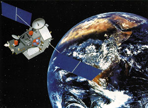 The Tropical
Rainfall Measuring Mission¹s (TRMM) Microwave Imager (TMI) is a passive
microwave sensor designed to measure rainfall over a wide swath under
the TRMM satellite. By carefully measuring the minute amounts of microwave
energy emitted by the Earth and its atmosphere, the TMI provides estimates
of the water vapor quantity and of the rainfall intensity in the atmosphere.
The Tropical
Rainfall Measuring Mission¹s (TRMM) Microwave Imager (TMI) is a passive
microwave sensor designed to measure rainfall over a wide swath under
the TRMM satellite. By carefully measuring the minute amounts of microwave
energy emitted by the Earth and its atmosphere, the TMI provides estimates
of the water vapor quantity and of the rainfall intensity in the atmosphere.