
|
 |
|
Remote
Sensing for Public Health Surveillance and Response The Application: Social and Economic Value In the past few years, environment-related public health problems have rapidly risen in importance on national and international science and policy agendas. As recently as 14 February 2002, President Bush announced the "Clear Skies" Initiative "...to help protect Americans from respiratory and cardiovascular diseases by dramatically reducing smog, acid rain, fine particles, regional haze, nitrogen and mercury deposition...and save as much as $1 billion annually in compliance costs...." National and international interdisciplinary health and Earth science groups have identified as a high priority a number of key environment-related public health issues: infectious and vector-borne diseases, air quality, water quality, environmental contaminants, thermal stress (heat waves, cold spells), extreme weather events and disasters, coastal water issues such as harmful algal blooms, famine and nutrition, demographic and economic disruption, ozone depletion, and ultraviolet radiation exposure. A growing number of scientific studies have emphasized the pressing need to address not only environment-, weather- and climate-related public health problems, but also the impacts of complex interactions among multiple environmental stressors and the human system. Improving our understanding of these interactions and impacts requires far better knowledge of the links between environment, weather, climate and health. Implementation In response to the clear need for improved observations of environmental factors to better understand the links between the environment and public health outcomes, and to respond to direct requests from the public health community for data relevant to specific health problems, NASA’s Earth Science Enterprise (ESE) has established "Healthy Planet," an environment and public health research and applications program led by Goddard Space Flight Center (GSFC). This program has been built upon the strong scientific base of disciplinary and interdisciplinary research results produced from the ESE Science Program over past decades. Recent results and data from the ESE Science Program that have been incorporated into exciting, interdisciplinary environment-public health applications research include such areas as global and regional terrestrial and marine biosphere, precipitation, surface temperature, humidity, atmospheric dynamics and pollutants, weather and climate, aerosols, ozone, air-sea-land-ice interactions, cloud properties, ocean productivity, and sea-surface temperature and dynamics.
Healthy Planet is conducting a number of interdisciplinary projects that demonstrate the application of remotely sensed data and information to a variety of real and potential public health threats, including West Nile virus, malaria, Rift Valley fever, environmental contaminants and their transport, St. Louis encephalitis, dengue fever, urban heat and health, Ebola, meningitis, asthma and other respiratory problems, filariasis, and African and Asian desert dust. In addition, the program is creating a user-friendly data system to help provide the public health community with easy and timely access to air- and space-based environmental data for epidemiological purposes. The data system is being designed to bring land, atmosphere, water, and ocean satellite data and data products to users who are not familiar with remotely sensed data and information. The following section provides several examples of the projects in this new program. Vector-borne Disease Detection Studies Using near-real-time climate data and satellite imagery, a team of NASA scientists led by Dr. J. Compton Tucker is developing the ability to map and monitor ecoclimatic patterns associated with various disease outbreaks. For example, the team has discovered environmental triggers for Rift Valley fever and other diseases, and can make predictions of Rift Valley fever outbreaks up to five months in advance in Africa. Childhood Asthma in Baltimore This interagency study, led by Dr. Elissa Levine of GSFC, is investigating climate and environmental links to asthma in Baltimore, Md., a city in the top quintile for children’s asthma in the United States. A comprehensive suite of climate, environmental and remotely sensed data, together with a variety of clinical and public health data, is being collected and integrated using geographic information systems (GIS) to determine which parameters have possible relationships to the occurrence of asthma. African Dust and Health–Africa, Asia and Beyond Hundreds of millions of tons of dust are transported by the wind each year from sources such as Africa and Asia to distant locations around the world. Together with their partners at GSFC, two NASA-funded teams–one led by Dr. Joseph Prospero of the University of Miami’s Rosenstiel School of Marine & Atmospheric Science, and another led by Dr. Gene Shinn of the U.S. Geological Survey–are studying the potential health effects of this dust and its contents, which includes microbes such as bacteria, viruses and fungi, as well as pollutants. Remote Sensing Technologies for Health Applications Although an extensive suite of Earth remote sensing systems has been placed into orbit since Landsat-1 was launched in 1972, most remotely sensed data used in public health studies has been acquired by such passive remote sensing systems, as NASA’s Landsat Multispectral Scanner (MSS) and Thematic Mapper (TM), NOAA’s Advanced Very High Resolution Radiometer (AVHRR), and the Systeme Pour l’Observation de la Terre (SPOT) of France. These data have focused primarily on land-surface variables and their application to epidemiological studies for infectious and vector-borne diseases. However, many other environmental factors important to public health issues are observable through remote sensing, such as air and water quality, thermal extremes, ultraviolet radiation, oceanic harmful algal blooms, and pollutant/pathogen transport and deposition via the atmosphere, oceans, ice and rivers. Information about land use and land cover, including the extent of urbanization over time, agricultural activity and vegetation phenology, can also be observed with remote sensing. Additional useful parameters observable with remote sensing are related to weather and climate, including such extreme events like drought, hurricanes, tornados and cyclones. Storms with excessive rainfall often result in serious flooding that creates health risks directly through injury and infection, or indirectly from epidemics of such water-borne diseases as cholera and typhoid fever, and such vector-borne diseases as malaria and dengue fever. A wealth of remote sensing resources for weather and climate information is available to scientists and decision-makers who are addressing environment-related health problems. Conclusion In mapping the road to a sustainable future as human populations expand and develop across the globe, the importance of applying advanced science and technologies toward preserving the planet’s life-support system becomes a national and international imperative. Healthy Planet is working with public health community partners to apply NASA’s most current scientific results and technologies from the ESE Science and Technology programs to interdisciplinary studies of the interactions between the environment and humans. These studies contribute to forward-thinking strategies of disease prevention and health promotion, such as those laid out by the U.S. Department of Health and Human Services in "Healthy People 2010: Understanding and Improving Health." The Healthy Planet program provides NASA Earth science observations and data to the public health community for use in their decision support systems for disease surveillance and response, prevention and planning, for disaster management, and for the development of new public health technologies and methods. Acknowledgments Funding for this program was provided by NASA’s Earth Science and Public Health Program, Office of Earth Science. About the Author: Nancy G. Maynard, Ph.D., is associate director for Environment and Health at NASA’s Goddard Space Flight Center. Her current research interests include applications of Earth remote sensing for public health, aerobiology, health impacts and transport of African and Asian dust, and air-water-land-ice transport of microbes and contaminants. She can be reached via e-mail at [email protected], or by phone at 301-614-6572. |
 NASA
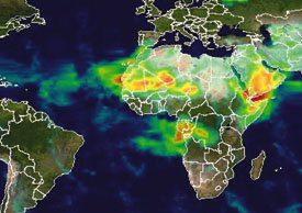
Total Ozone Mapping Spectrometer (TOMS) data for ultraviolet-absorbing
aerosols (dust and smoke) shows a dust plume from the Sahara, smoke from
southern Africa, and dust from the Arabian Peninsula and from China. Further
north, TOMS detected smoke over Russia and Canada. The white color represents
ice in Greenland, northern Canada, Russia, and Antarctica. The background
map (ice, land, and oceans) was obtained from the Moderate Resolution
Imaging Spectroradiometer (MODIS).
NASA
Total Ozone Mapping Spectrometer (TOMS) data for ultraviolet-absorbing
aerosols (dust and smoke) shows a dust plume from the Sahara, smoke from
southern Africa, and dust from the Arabian Peninsula and from China. Further
north, TOMS detected smoke over Russia and Canada. The white color represents
ice in Greenland, northern Canada, Russia, and Antarctica. The background
map (ice, land, and oceans) was obtained from the Moderate Resolution
Imaging Spectroradiometer (MODIS).