
|
 |
|
Satellite
Observations and Seasonal Climate Forecasts for Agriculture Applications The spring and summer of 1988 brought dry conditions to almost a quarter of the continental United States, mostly over the northern Great Plains. The Midwest experienced its worst dry spell since the 1930s, impacting the nation’s most productive agricultural lands and causing an estimated $40 billion in crop damage. In contrast, the summer of 1993 was exceptionally wet in the same area, with flooding on the Missouri and Mississippi rivers, while conditions in the eastern United States were dry. A severe drought in eastern Africa in 1984 led to widespread famine that killed over 700,000 people. Africa suffered its worst dry spell of the 20th century in 1991-92, with a drought that covered a region of 6.7 million square kilometers and affected nearly 24 million people. The Importance of Predicting Climate Anomalies Floods and droughts are the most damaging of all natural disasters. Since 1967, drought has been responsible for millions of deaths and has cost hundreds of billions of dollars in damage worldwide. Economies in all areas of the globe are affected by interannual climate anomalies such as flood and drought. For example, regional climate anomalies in southeast Asia have a significant impact on rice crop production. Rice is the staple diet for about three billion people, and about 90 percent of the world’s rice is produced in Asia. While rice can be grown at any time of the year in the tropics, this product is mainly grown during the wet season where many farmers practice rain-fed rice farming. By 2025, that portion of the world’s population dependant upon rice production is expected to reach 4.6 billion, so forecasts of climate anomalies would be imperative. Northeastern Brazil is another region where climate anomalies have a significant effect on the economy. Interannual variations in precipitation and surface temperature are great in northeastern Brazil, and climate variability affects the production of corn, beans and cotton, with drought events causing major losses. Many interannual climate anomalies can be tied directly to phenomena such as El Niño or La Niña. Others cannot, such as the current drought conditions throughout the eastern United States. The El Niño/Southern Oscillation (ENSO) is a quasi-periodic phenomenon that tends to recur every two to seven years. The ENSO results from large-scale interactions between the ocean and the atmosphere and is manifest as two nearly opposite phases: El Niño, the warm phase, and La Niña, the cold phase. During the warm phase, sea surface temperatures are warmer than normal in the eastern tropical Pacific Ocean, and major tropical precipitation regions are displaced from the continents to the tropical oceans. During the cold phase, opposite conditions tend to occur. El Niño is usually associated with droughts in Indonesia, Australia and northeastern Brazil, whereas La Niña is usually associated with good rains and favorable agricultural production in these areas. In addition to their impact in the tropics, the shifts in tropical rainfall patterns force changes in the atmosphere over the entire globe. Perhaps the most important response away from the tropics is a shift in the position of the mid-latitude jet stream, altering the course of storms that determine daily weather fluctuations at higher latitudes. It is clearly important to monitor the state of the Earth’s climate as a way of providing information to farmers and to organizations responsible for food and water management. Reliable forecasts of precipitation and surface temperatures provided one season in advance would have an enormous economic impact throughout the world. Observations That Help Satellite remote sensing provides the potential for global coverage of critical data, such as precipitation, soil moisture, snow water content, vegetation maps, and ocean surface temperatures, to help monitor existing anomalies and to improve climate forecasts. Such data can be obtained globally and repeatedly from satellite observing networks. For example, sea-surface temperature variations have been monitored since the early 1980s by Advanced Very High Resolution Radiometers (AVHRRs) aboard National Oceanic and Atmospheric Administration (NOAA) satellites. The accuracy and spatial resolution of these measurements improved with NASA’s launch, in 1999, of the Moderate-resolution Imaging Spectroradiometer (MODIS) aboard the Terra spacecraft. In addition to providing sea-surface measurements, the AVHRR and MODIS sensors also provide information on terrestrial vegetation by monitoring water-stressed regions through derived products, such as the leaf-area index and the normalized-vegetation index. Ocean subsurface temperature variations, which hold the long-term memory of climate anomalies, are being inferred from surface altimetry measurements acquired by TOPEX/Poseidon and its follow-on, Jason-1, both joint missions of NASA and the French space agency. These measurements hold the potential for improving forecasts of sea-surface temperature and of the accompanying changes in tropical rainfall distributions. In another joint effort, NASA and the Japanese space agency are conducting the Tropical Rainfall Measuring Mission to monitor and study tropical rainfall over both oceans and land mass. The associated release of energy from tropical rainfall helps to power the global atmospheric circulation that shapes both weather and climate around the globe. A multinational payload on the recent Aqua launch included six sensors that were designed to acquire climate-related measurements. One of these sensors, the Advanced Microwave Scanning Radiometer for EOS, will monitor various water processes that exert a strong influence on climate and weather. Challenges of Seasonal Prediction Since the dramatic influence of the large El Niño event of 1982-83, one that was totally unanticipated, scientists have increased their efforts to forecast anomalous sea-surface temperature patterns in the tropical oceans, and to determine their potential impact on other areas of the globe. Significant advances have been made in forecasting the evolution of warm and cold events once they have begun. These advances have arisen from improved computer models used in forecasts, and from an enhanced tropical ocean observing system that includes AVHRR, the surface altimetry from TOPEX, and NOAA’s Tropical Atmosphere Ocean moored buoys, which provide information on subsurface ocean temperatures. In spite of these advances, however, forecasting prior to their initiation remains a challenge. Although responses to El Niño or La Niña episodes are strong and widespread, the differences in responses from region to region and between events make forecasting the details difficult. Yet these details are important if the forecasts are to be useful for practical applications, such as water management and agricultural planning. The challenge for seasonal prediction is in understanding the mechanisms that contribute to extreme climate anomalies and the factors and feedbacks that enhance the prediction of these anomalies. What Controls Prediction Skill? The chaotic nature of weather and climate systems contributes to the challenge of prediction. Two crucial aspects of prediction include knowing which events one should be able to predict, and knowing which variables or observables hold the key to prediction skill. To that end, scientists use large ensembles of model simulations to mimic the chaotic nature of the atmosphere to assess the predictability of precipitation and surface-temperature anomalies on seasonal time scales. These studies have shown that tropical sea-surface temperature is only one of the agents that force anomalies over the mid-latitude continental regions. On land, the "memory" inherent in soil moisture during summer months has shown the potential for improving regional climate forecasting skill. Soil moisture distributions integrate the effects of previous atmospheric forcing over an extended period, and amplify the effects of sea-surface temperature anomalies from prior seasons. No routine measurement of soil moisture exists just yet, but investigations continue to extract soil moisture information along with vegetation observations. A Circular Application Exchanges between the land surface and the atmosphere are mediated by vegetation. Therefore, changes in land use and land cover, and the regulation of irrigation and stream flow, can ultimately affect seasonal and interannual variations in land hydrology. These types of changes, which are often human-induced, must be included in forecast models because they can affect the level and distribution of the transfer of heat and water between the land and the atmosphere. Satellite observations help us document and understand these changes and provide critical data to help improve forecasts of regional climate anomalies to support agriculture and water management. Seasonal climate forecasting requires an understanding of the complex global interactions between the ocean, atmosphere, land, and vegetation. Only a comprehensive system of repetitive measurements of each system, over the entire globe, both in situ and from space, will increase that understanding. The use of that understanding to improve computer models and forecasts of seasonal trends is but one goal. Providing usable information for end-user applications must remain a high priority. Acknowledgments This work is funded by the NASA Earth Science Enterprise Research and Analysis Division through its Global Modeling and Analysis and its Physical Oceanography programs. Computational facilities are provided by the NASA Center for Computational Sciences at Goddard Space Flight Center.u About the Author: Michele Rienecker and David Adamec are oceanographers in the Laboratory for Hydrospheric Processes at NASA’s Goddard Space Flight Center. They participate in the NASA Seasonal-to-Interannual Prediction Project that develops techniques for using satellite observations to improve climate forecasts. Ms. Rienecker can be reached via e-mail at [email protected]. Mr. Adamec can be reached via e-mail at [email protected]v. |
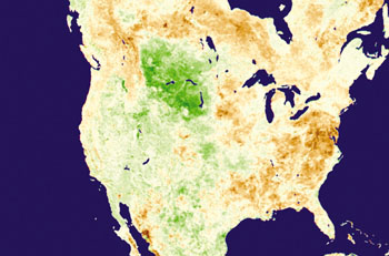 Shifts
in weather patterns can cost lives and cause billions of dollars in damage
by drying and withering croplands in some parts of the world, while flooding
croplands in other regions. El Niño and La Niña conditions
generally intensify such severe weather events. Knowing when and where
drought or flood conditions are likely to occur has multiple benefits;
for example, commercial growers can plant crops that are more resistant
to upcoming wet or dry conditions, and famine relief program managers
can deploy personnel and direct supplies where and when they will be most
needed. Applying NASA satellite remote sensing data in conjunction with
predictive climate models can help scientists pinpoint where and when
drought and flood conditions are likely to occur.
Shifts
in weather patterns can cost lives and cause billions of dollars in damage
by drying and withering croplands in some parts of the world, while flooding
croplands in other regions. El Niño and La Niña conditions
generally intensify such severe weather events. Knowing when and where
drought or flood conditions are likely to occur has multiple benefits;
for example, commercial growers can plant crops that are more resistant
to upcoming wet or dry conditions, and famine relief program managers
can deploy personnel and direct supplies where and when they will be most
needed. Applying NASA satellite remote sensing data in conjunction with
predictive climate models can help scientists pinpoint where and when
drought and flood conditions are likely to occur.