
|
 |
|
A
Change in the Weather: How NASA is Leading a Revolution in Weather Measurements The weather affects every American, every day. Few phenomena have such widespread impact on people’s personal lives, including their jobs, their recreation, their safety, and their property. When the weather is bad, many activities become more difficult to perform. People who work outside cannot make as much progress. Commercial transportation slows down on the roads, on the waterways, and in the air. Businesses of all kinds are hampered by bad weather. Power plants and energy traders rely on knowledge of the weather to operate their equipment and to deliver power to consumers, government and business. Knowledge of the weather and associated winds allows commercial and general aviation to operate safely through hazardous weather avoidance, and to operate more efficiently through fuel savings. The military operates differently in different kinds of weather, and military systems rely on knowledge of the weather to be effective. Intense weather, such as storms, tornadoes and hurricanes, threatens the safety of people and of property. When all of these factors are taken together, it is easy to see that weather in this country is responsible for the loss of tens of billions of dollars each year. Better knowledge and prediction of the weather will increase economic productivity, improve our nation’s defense capabilities, and save lives. The importance of the weather and the need to predict it accurately is illustrated by the fact that every local news show includes weather forecasts. People need to know what the weather will be like–either where they are or where they are going–so that they can plan their activities accordingly. One of the problems with weather forecasting is that weather changes quickly in time and space. A weather forecast at 8:00 in the morning may not be reliable at 3:00 that same afternoon. A weather forecast in one city is not valid for neighboring regions. For this reason, local weatherpeople never say what will happen, only what is likely to happen in the local area. The physical processes at work in the atmosphere are very complex. If we want to know with more certainty what the weather will be like, we must make measurements of the physical properties of the atmosphere more often and in more locations than we’re making today. The Properties of Weather What are the atmospheric properties that determine the weather? The study of weather, or meteorology, is the study of the interplay between atmospheric temperature, pressure, humidity (how much water is in the air, including clouds), and winds. Current systems for monitoring these weather variables include ground stations, radars, balloons, and national satellite systems, both in low Earth orbit and in geostationary orbit some 36,000 kilometers above the Earth. The U.S. national weather satellite system is operated by the National Oceanic and Atmospheric Administration (NOAA), was developed by NASA, and was paid for with taxpayer dollars. All the satellite pictures you see on the local news and on the Weather Channel are paid for by you and me. All these measurements from all these systems are combined into computer models used by NOAA to predict the weather at any given place and time (figure 1). As we all know, the best predictions of weather are less than reliable, and when predicting more than a day into the future, the reliability of forecasts decrease even more. Again, weather prediction is difficult because of the complex physical nature of the atmosphere. Numerical weather predictions can be made to be more accurate by improving the physics of the computer models that simulate the atmosphere, and by improving the accuracy, frequency and spatial coverage of the atmospheric observations used to define the state of the atmosphere needed to initialize the computer predictions. Thus, we need to provide weather observations to the forecasting models more often and at more places in the atmosphere. A revolutionary new weather measurement system is currently under development by NASA to do just that. Through a partnership with the Department of the Navy and NOAA, NASA is building the next-generation weather measurement system to provide computerized forecasting models with the right number of measurements as often as necessary to improve dramatically our ability to forecast the weather. A New Way to Measure the Weather NASA is funding this weather measurement system through the New Millennium Program (NMP). The NMP is designed to prove new component and system technologies. One of NASA’s mandates is to provide NOAA with new technologies for its national weather system. The original name for this project was GIFTS, which is an acronym for the type of instrument to be used: Geostationary Imaging Fourier Transform Spectrometer. NASA teamed with the Navy to fund the GIFTS proof-of-concept mission, and the Navy recognized that GIFTS could greatly improve weather observations needed for operations of its fleet at sea. The Navy then combined its own Indian Ocean Meteorological and oceanographic Imager (IOMI) project with NASA’s GIFTS project to fulfill its needs, and the project was renamed GIFTS-IOMI. The mission objective is to build a remote sensor to measure weather variables in every four-kilometer square on the surface, and every one- to three-kilometer vertically through the atmosphere. This instrument will be placed in geostationary orbit where it can view the same region on the ground almost continuously. This vantage point allows new measurements for any given place to be obtained with a time frequency of seconds to minutes; the exact time interval will be dependent upon the total Earth coverage desired throughout the day. This architecture allows the needed increase in the number of places (100-1000X) where weather measurements are made and also provides the measurements much more often. This increase in the number and frequency of measurements will better constrain forecasting models to simulate the real atmosphere and its dynamic variations, thereby increasing dramatically the reliability of weather forecasts, including hurricane track forecasts (figure 2). The end result will be an improvement in this nation’s overall economic efficiency, in the military’s effectiveness, in the saving of property and lives, and in our overall quality of life. What is GIFTS-IOMI? What is it about this new instrument that makes it special? Actually, the basic instrument concept is over a hundred years old. The GIFTS-IOMI uses a Michelson interferometer, designed originally to test the theory of the "ether" in the early 1900s. The Michelson interferometer signal is then transformed, using a technique named after a scientist named Fourier who worked in the 1800s. However, NASA engineers and scientists have combined the latest research performed at universities, in industry, and within NASA’s Langley Research Center, to build a unique and revolutionary capability (figure 3). This Michelson interferometer uses the latest digital-camera, infrared-sensing detector technology to work from geostationary orbit simultaneously in four dimensions (i.e., in the three spatial dimensions plus time). The instrument is relatively small and lightweight, and it has the computing power to fully exploit the concepts discovered by Michelson and Fourier. Examples of the breakthroughs incorporated into this new instrument include new stiff, lightweight materials for the structure and for the light-collecting mirrors, large two-dimensional detector arrays for infrared light detection, radiation-hardened electronics, and computers for collecting and analyzing billions of bits of data every second. Not only is this new instrument significantly better than any other sensor ever deployed, it is also smaller and more lightweight, thus saving millions of dollars in launch costs. Current plans are to launch this instrument in November 2005. GIFTS-IOMI will operate over the west coast of the United States during the winter months to demonstrate the improvement in Pacific storm forecasts, and then the sensor will spend the spring, summer, and fall over the east coast to demonstrate improvements in the observation and forecasting of continental severe storms and Atlantic ocean hurricanes. The satellite will then be moved to a position over the central Indian Ocean where the Navy will use it to support its ships operating in that region of the world. Once a fully operational satellite system based on this technology is in place (possibly by 2012), the system will affect dramatically the lives of everyday Americans. By providing today’s weather forecasting models with more data, more often, it is projected that weather forecasts can be made reliable for many days at a time. Perhaps more importantly, weather forecasts can be provided to citizens for their specific location, not just for the nearest large city. The system’s four-dimensional view of the atmosphere’s water vapor will tell us where severe storms will occur hours before their clouds form and become visible in conventional satellite imagery and hours before their rains begin and become visible on radar (figure 4). Improved weather forecasts will increase economic productivity because work crews will know when to report for work, drivers will know the fastest route to take, energy production will become more efficient, airlines will be able to plan for adverse conditions and optimize flight routes for fuel savings, and farmers and communities will be better prepared for storms, floods and drought. Impacts that will not be immediately apparent, but that grow from the increased understanding we gain of the Earth system as a whole, include climate change, the effects of pollution, and the processes that drive major storms, such as hurricanes, cyclones and tornadoes. For example, better prediction of hurricane landfall will save over a million dollars per mile of coastline that does not need to be evacuated. Further savings will come as people in the path of such storms, now confident of the predictions, will take proper measures to secure lives and property. Another example of the dramatic, widespread societal benefits that come from a better understanding and improved prediction of the weather is illustrated through the aviation industry. Aircraft currently receive weather data through the same system as that of your local meteorologist. Predictions are updated only once every several hours based on limited measurements, and predictions are given for large regions, not specific locations. Planning is now underway to use the measurements of a GIFTS-IOMI-like system to provide local weather reports directly to an aircraft’s cockpit for both commercial and general aviation, allowing pilots to make real-time decisions that impact flight safety and efficiency. Implementing this system will result in improved safety for people and aircraft as well as millions of dollars in savings on fuel costs alone. General productivity will increase because travel time and delays will decrease. People will arrive at their planned destinations on schedule. In addition, future air transportation systems being developed by NASA (e.g., the Small Aircraft Transportation System) will require more airplanes and more airports as air travel becomes more like ground travel. If possible, people want to travel directly from point to point. This revolutionary change in air travel will require accurate, localized weather forecasts to enable take-off and landing at thousands of locations around the country. In summary, a revolution in weather prediction is underway, led by an efficient coalition of government agencies, universities and industry partners. A system to be launched in 2005, developed under the leadership of NASA’s Langley Research Center, will demonstrate how thousands of weather measurements can be made every minute and used continually throughout the day and night. These measurements are precisely the information needed to improve dramatically weather forecasting reliability and thus increase economic productivity, improve our nation’s defense, and save property and lives. The quality of life for all of us will be greatly enhanced as a result of the GIFTS-IOMI development and deployment. Acknowledgments This mission was first proposed by NASA’s Langley Research Center in partnership with the University of Wisconsin and Utah State University. The mission is funded by NASA’s Earth Science Enterprise through the New Millennium Program, by the Navy’s Office of Naval Research through the Indian Ocean Meteorology and Oceanography Imager Program, and by the National Oceanographic and Atmospheric Administration’s National Environmental Satellite, Data, and Information Service. NASA’s Langley Research Center leads overall mission development.u About the Authors: Mr. Stephen Sandford is director of the Earth and Space Science Program Office at NASA’s Langley Research Center in Hampton, Va. His former positions at Langley include head of the Electro-Optics and Controls Branch and deputy director for Atmospheric Sciences. Mr. Sandford has also led research and flight developments in high-altitude and space-based LIDAR and in passive sensing instruments. His research interests include laser frequency control and remote sensing instrumentation. Mr. Sandford can be reached at [email protected] or at 757-864-6122. Dr. Bill Smith is the chief scientist of Atmospheric Sciences Competency at NASA’s Langley Research Center. He is the principal investigator for the GIFTS-IOMI mission and for the National Polar-orbiting Operational Environmental Satellite System (NPOESS) Aircraft Sounder Testbed Airborne Fourier Transform Spectrometer (FTS), used to demonstrate many of the capabilities of the FTS for making key meteorological measurements from both polar and geosynchronous orbits. Dr. Smith can be reached at [email protected] or at 757-864-5914. |
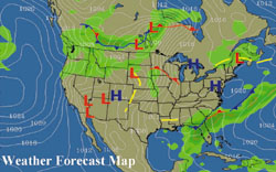 Observations
of current weather are used to generate numerical analyses that are fed
into computer models to predict the future state of the atmosphere.
Observations
of current weather are used to generate numerical analyses that are fed
into computer models to predict the future state of the atmosphere.