
|
 |
|
The
National Invasive Species Forecasting System: A Strategic NASA/USGS Partnership
to Manage Biological Invasions Non-indigenous invasive species may pose the 21st century’s single most formidable threat of natural disaster. During the past hundred years, non-indigenous plants, animals and pathogens have been introduced at increasing rates into all U.S. ecosystems. A growing number of these species are becoming invasive, and they contribute to declines in native species and to changes in ecosystem function. The direct cost to the American economy alone is estimated at $100-200 billion per year, greater than all other natural disasters combined. An invasive species is defined as a non-native species whose introduction causes or is likely to cause harm to the economy, the environment, or to human health. The cost of infestations of leafy spurge alone to agricultural producers and taxpayers is $144 million a year in the Dakotas, Montana and Wyoming. Aggressively invasive fish in the Great Lakes threaten a commercial fishery that supports 81,000 jobs and is valued at $4.5 billion. Invasive Norway rats cause up to $19 billion in environmental and economic damage every year. Non-native livestock diseases cost $9 billion a year. In the coming decades increased human travel and trade, and the changing types and patterns of environmental disturbance, are expected to exacerbate these impacts. Because of its high diversity of environmental conditions and habitats, the United States is especially vulnerable to invasions by non-indigenous species.
This issue has developed diverse stakeholder support, ranging from land management agencies to state governments, the agricultural industry, conservation organizations, and private landowner groups. The National Research Council’s Committee on Grand Challenges in Environmental Sciences has identified increased understanding of biodiversity and ecosystem functioning as one of eight "Grand Challenges in Environmental Science" that face our nation and the world today. The committee also emphasized the need to develop improved management techniques and an ecological forecasting capability for non-indigenous invasive species. NASA and the U.S. Geological Survey (USGS) are joining forces to take on this task. Their combined resources and shared expertise will result in a National Invasive Species Forecasting System for the management and control of invasive species. Finding a Solution The U.S. government has begun to mount an organized effort to address the invasive species threat, coalescing around Executive Order 13112 issued in 1999. The newly formed National Invasive Species Council has issued a draft management plan and assembled several technical working groups. The National Biological Information Infrastructure has regional programs that are developing invasive species information systems as their highest priority initiative, with plans to establish a national node for invasive species in 2002. However, the invasive species threat affects not only the United States. Globalization has greatly increased the international movement of harmful species through travel and the agricultural, horticultural and pet industries; the invasive species threat has become a principal impediment to international trade agreements. As a result, the U.S. government is coordinating its efforts with international initiatives under the United Nations’ Global Invasive Species Programme, the North American Free Trade Agreement’s North American Biodiversity Information Network, the Summit of the Americas’ Inter-American Biodiversity Information Network, and a number of bilateral agreements to develop international exchange on invasive species information. Each of these efforts recognizes the central role of NASA’s space-based sensors and advanced computational, modeling and information technologies in addressing invasive species science and policy on a national and global scale. Both the potential for movements of invasive species and the susceptibility of sensitive habitats to new invaders are known to be strongly influenced by climate warming, plus changes in rainfall, soil moisture and runoff, and are increasingly driven by extreme events. Therefore, a wide range of existing and emerging NASA Earth Science Enterprise technologies will be central to a better understanding of invasive species risks. At the same time, many invasive species greatly alter the water relations, carbon storage, fire cycle, and reflectance properties of landscapes. The study of invasive species themselves may be an important feedback link to understanding climate systems. To cope with the domestic threat, the NASA Office of Earth Science and the U.S. Geological Survey (USGS) are developing a National Invasive Species Forecasting System for the management and control of invasive species on all U.S. Department of Interior and adjacent lands. This project will use early detection and monitoring protocols and predictive models developed at the USGS Fort Collins (Colo.) Science Center to process NASA and commercial data, and to create on-demand, regional-scale assessments of invasive species patterns and vulnerable habitats. The community of ecologists and land managers who will use this application will be involved in all stages of its development. The system will be made broadly available to the natural resource management community through the Internet-based USGS National Biological Information Infrastructure program. This project builds on NASA’s unique remote sensing capabilities and on current joint USGS/NASA work on invasive species. The end product will be a dynamic and flexible system for generating electronic and paper maps of hot spots for potential exotic species invasions. These maps will be used by private and public national, state and local management agencies for remediation, management and control. Over the next 10 years, it is envisioned that the National Invasive Species Forecasting System will provide revolutionary capabilities of fundamental importance to understanding and managing the effects of invasive species on human health, the economy, native biodiversity, and ecosystem processes. Mapping an Approach High-resolution mapping of biological resources is central to confronting the invasive species threat. To meet the needs of invasive species science and policy communities, one must be able to identify dominant plants and vegetation structures with a reasonable ability to distinguish between species. Such identification is becoming possible with hyperspectral instruments at meter-scale resolutions, particularly when combined with light detection and ranging (LIDAR) and other active sensors that can detect meter-scale vegetation structure, landforms, and soil surface properties. The USGS uses advanced geostatistical methods, many derived with NASA Earth Science Enterprise support, to integrate multiple types and scales of data, including satellite images, aerial photography, and ground data of various resolutions to map biological resources. This project will proceed through three major phases. The first phase will involve developing a prototypical Invasive Species Forecasting System at selected test sites that include Rocky Mountain National Park (Colo.), the Cerro Grande Wildfire Site (N.M.), and Grand Staircase-Escalante National Monument (Utah). Sites will be chosen in consultation with the USGS ecologists, land managers in bureaus of the Departments of Agriculture and the Interior, and private stakeholder groups. At each test site, project scientists will compile existing field survey data, ground measurements, and airborne and satellite data. Local and regional models will be refined and tested. The second phase will expand the system to include high-resolution hyperspectral and other measurements in the modeling protocols. Performing periodic, on-demand national assessments of management-scale risks will require unprecedented data integration and computing capacity, the infrastructure for which will be developed during this second phase. In phase three, the system will be deployed beyond the test sites and expanded into a fully operational National Invasive Species Forecasting System for use throughout the Department of Interior. The system will be made widely available to the scientific and management communities through the USGS National Biological Information Infrastructure program, which provides U.S. interagency coordination for online biological databases and information services. Why NASA? Why Now? The National Invasive Species Council has noted, "No comprehensive national system is in place for detecting and responding to incipient invasions." Yet the threat of invasive species is perhaps our most urgent economic and conservation challenge. There is a growing sense among land management agencies that a national assessment of native and non-indigenous plant diversity needs to be completed on all public lands. Particularly high on the agenda are issues such as detecting the loss of native plant diversity caused by non-indigenous plant species, predicting where non-indigenous species are most likely to damage native diversity, and developing a science-based, long-term monitoring plan for vegetation and soil resources. Development of the National Invasive Species Forecasting System addresses concerns that are common to most land managers, and NASA has an essential role to play in helping the USGS build this capacity. NASA’s unique national role in developing remote sensing capabilities and in understanding the Earth system, coupled with the urgency of the invasive species threat, the ready partnership of the USGS, and the compelling societal and economic benefits of this effort, make this project strategically important to NASA. The techniques developed here will also have immediate use in many current and planned NASA Earth Science Enterprise research programs. Specifically, these methods will be applicable to a range of ecological predictive problems, including mapping national and global carbon storage, disease outbreaks, climate change, and temporal and spatial changes in oceans. The same methods needed by agricultural authorities to eradicate an invasion of hoof-and-mouth disease can also be applied to dangerous species deliberately introduced by bioterrorists. Roles and Responsibilities In the United States, the USGS has the lead role in delivering scientific information concerning invasive species on federal lands. Technical and scientific capabilities of the USGS directly support the management of Department of Interior lands and waters by documenting, monitoring and predicting the establishment and spread of invasive species. The USGS studies the ecology of invading species and vulnerable habitats to support prevention, early detection, assessment, containment and, where possible, eradication of new invaders; the USGS also investigates the physical properties, composition, and hydrology of geologic substrates to identify lands vulnerable to invasion by exotic plants. The USGS National Biological Information Infrastructure has several regional programs that deliver invasive species information. The agency is also establishing a national node for invasive species. NASA has a uniquely complementary and synergistic role to play in helping the USGS understand and manage invasive species. NASA’s Earth Science Enterprise currently provides measurements from Terra, QuickSCAT, Landsat 7, Jason, and other missions that map key ecosystem attributes needed to predict invasive species distributions. A number of planned missions in the near- to mid-term will expand these measurements to include critical three-dimensional structure derived from synthetic aperture radar (SAR) and LIDAR technologies. Measurements are also supported through data purchase programs, including SeaWiFS ocean color imagery, high-resolution optical imagery from IKONOS, QuickBird, and other private-sector satellites, and land-cover data from the Landsat Data Continuity Mission. In addition, NASA provides the computational capabilities and expertise in large-scale, coupled Earth system modeling needed to ensure the successful transfer of the system into operational use. In Closing Recent funding from NASA’s Earth Sciences Technology Office / Computational Technologies and Carbon Applications programs has helped create this NASA/USGS partnership that will result in high-performance models and system prototypes directly relevant to invasive species prediction and monitoring. The USGS is making significant programmatic commitments to the effort and will soon open new facilities at its Fort Collins Science Center to focus on invasive species science. The National Invasive Species Forecasting System is an application of extraordinary promise for managing one of the 21st century’s most formidable threats of natural disaster. Acknowledgements This work is funded through the NASA Earth Science Enterprise Applications Division and the Earth Science Technology Office Computational Technologies program. Additional support is provided by the U.S. Geological Survey’s Fort Collins Science Center and Colorado State University’s Natural Resource Ecology Laboratory and Department of Forest Sciences.u
About the Authors: John L. Schnase, Ph.D., is a senior computer scientist in the Earth and Space Data Computing Division at NASA Goddard Space Flight Center and is the principal investigator for the joint NASA/USGS invasive species project. He may be reached via e-mail at [email protected]. Thomas J. Stohlgren, Ph.D., is the Director of the National Institute of Invasive Species Science at the USGS Fort Collins Science Center and is a co-investigator on the joint NASA/USGS invasive species project. He may be reached via e-mail at [email protected]. James A. Smith, Ph.D., is a senior scientist in the Laboratory for Terrestrial Physics at NASA Goddard Space Flight Center, a member of the EO-1 science team, and a co-investigator on the joint NASA/USGS invasive species project. He may be reached via e-mail at [email protected]. |
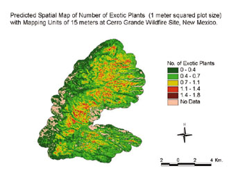 Predicted
spatial maps for the number of native and exotic plant species and for
nitrogen and carbon distribution in the Cerro Grande Wildfire Site near
Los Alamos, NM. On-demand landscape- and regional-scale maps such as these
that show "hot spots" for potential biological invasions, native biodiversity,
and other important environmental attributes will form the core of a national
invasive species decision support system infrastructure.
Predicted
spatial maps for the number of native and exotic plant species and for
nitrogen and carbon distribution in the Cerro Grande Wildfire Site near
Los Alamos, NM. On-demand landscape- and regional-scale maps such as these
that show "hot spots" for potential biological invasions, native biodiversity,
and other important environmental attributes will form the core of a national
invasive species decision support system infrastructure.