|
 |
|
Toward
a Carbon Management Regime The Problem The change in the distribution of carbon among the land, atmosphere and oceans is a fundamental natural process called the carbon cycle. Carbon dioxide (CO2) in the atmosphere is essential for photosynthesis, the process upon which all life on Earth is dependent. Carbon dioxide is also one of several atmospheric gases that control global temperature by absorbing and re-radiating energy emitted from the Earth’s surface. Carbon dioxide is not the most efficient gas at performing this function, but its relative abundance in the atmosphere makes it the most important. The atmospheric concentration of CO2 increased about 25 percent during the 20th century and will likely continue to increase through the 21st century. This increase is caused primarily by the release of CO2 from the burning of fossil fuels-coal, oil and natural gas–at rates that exceed those by which CO2, through natural processes, is removed from the atmosphere and stored on land and in the oceans. If no further action is taken to reduce the rate of increase in atmospheric CO2, the concentration of the gas by 2100 is likely to be about two and a half times higher than it was in 1900. Substantial evidence indicates that average global temperatures are warming in response to increased levels of atmospheric CO2. Further increases in CO2 concentrations are likely to have a profound impact on weather, climate and the habitability of the Earth. Warming of the planet will lead to increases in sea level and the flooding of low-elevation coastal areas–the current location of the majority of the Earth’s human population–and will change the duration and magnitude of severe storms. Climate change will likely shift weather patterns, thereby affecting agricultural productivity both negatively and positively, and will impact the distribution of flora and fauna, consequently changing the geography of disease. Global warming may also shift the location, size and nature of wetlands and may increase the emission of methane (CH4) from such ecosystems. Methane is a far more efficient greenhouse gas than carbon dioxide, and increasing the atmospheric concentration of methane may further stimulate the rate of global warming.
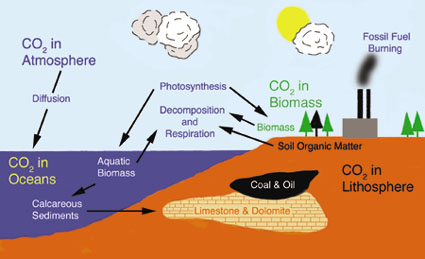
Schematic of carbon distribution and pathways for intersphere transfer. (Drawing: After Michael J. Pidwirny, Dept. of Geography, Okanagan University College Human activity has destabilized the carbon cycle both through the burning of sequestered fossil fuels and through land use and land cover changes, such as deforestation. The change in the distribution of carbon is perhaps the greatest impact of human activity on the Earth’s systems and must be addressed to ensure the continued habitability of the planet. Toward a Solution Barring a social or economic catastrophe that results in a sudden and sustained decline in energy demand, only the further development and application of new technology will substantially reduce emissions of atmospheric CO2 in the 21st century. The rate of increase of CO2 in the atmosphere has already been slowed by technological improvements in energy generation. However, technology alone is not sufficient to stabilize the concentration of atmospheric CO2 before it reaches levels at which profound climate change is likely; technology alone cannot reverse the trend of the last century. The path to stabilization of the carbon cycle and, ultimately, reduction in the concentration of atmospheric CO2 is though a regime of carbon management. Such a regime requires a comprehensive understanding of the dynamics of the carbon cycle and of the factors controlling the short-term and long-term storage of carbon in biomass, soils and oceans. Robust exploitation of natural carbon sinks is a vital element in a carbon management regime and has the potential to lower the rate of increase in atmospheric CO2 until new technology can lower the rate of carbon dioxide emissions. NASA is assisting in a U.S. Global Change Research Program initiative to develop a comprehensive carbon cycle research strategy. NASA’s Office of Earth Science (OES) is providing a research foundation and is assisting in the development and demonstration of applications to support a carbon management regime. The OES research and applications will be incorporated into decision support systems for carbon management by federal agencies. Climate and weather are major thrusts of the OES research program. Projects sponsored by the program use NASA’s unique capabilities in Earth observation to understand the fundamentals of climate–its natural state, how and why it is changing, and how it can be predicted. This research is providing insights into the carbon cycle that are prerequisites to an effective carbon management regime. In meeting its objectives, the OES research program is acquiring and archiving global, high-resolution, multispectral data and datasets as well as the land cover products derived from those data. Future datasets will likely include measurements of CO2 flux in the troposphere, forest height and canopy volume, and global surface soil moisture. While working with these data and data products, the OES is developing and testing process models that are tools for carbon management. The OES Applications Division extends the science, data and technology of the Research Division to the broader community to attain maximum social and economic benefits from NASA-sponsored research. Applications projects sponsored by OES integrate NASA-developed data, data products, models, and other capabilities into the operational decision support systems of federal agencies, which in turn provide benefits directly to citizens on an operational basis. Because carbon management is recognized as an application of national importance, the Applications Division is collaborating with several federal agencies to identify decision support systems that address carbon management and that can also be served by current and future NASA/OES capabilities. Current collaborative efforts involve the U.S. Departments of Agriculture, Energy, and the Interior, the Environmental Protection Agency, and the U.S. Agency for International Development (USAID). Each department and agency has different information requirements, although the requirements often overlap. The Applications Divisions’ strategy describes an approach to meeting the geospatial information needs of U.S. departments and agencies through capabilities roadmaps that lead to comprehensive decision support systems. Below are three examples of potential benefits that this process may bring to federal agencies: 1. Current land-cover and fire products derived from the Landsat Thematic Mapper (TM) and Enhanced Thematic Mapper Plus (ETM+), and from the Moderate Resolution Imaging Spectroradiometer (MODIS), are used by the U.S. Forest Service to monitor forest condition and change. Above-ground biomass is a potential storage place or sink for carbon, and future management of forests is likely to include carbon storage as a factor in management decisions. Other than experimental systems in development, existing data sources from NASA do not provide adequate volume or allometric measurements. Instrumentation developed within the next 10 years through the Earth Science Technology Office might provide such information and, when available, data from those systems will be used to improve models and decisions support systems for forest management. 2. The Department of Agriculture monitors agricultural productivity. Soil carbon is a key element in soil fertility. Agricultural soils can also serve as short-term sinks for carbon dioxide, depending upon management practices. NASA/OES-developed instruments, including the Advanced Very High Resolution Radiometer (AVHRR), MODIS, and Landsat TM and ETM+, are now used to monitor regional agricultural conditions and to provide within-year and next-year predictions of productivity. Similar measurements will be combined with data from new instruments to directly measure soil moisture and carbon flux to improve current decision support systems that consider soil fertility and carbon storage as part of a regional analysis of within-year and future productivity. Calibration and validation activities for existing sensors will focus on providing information on management practices, such as tillage and crop/fallow rotations. 3. The USAID sponsors projects to improve agricultural productivity in rural, impoverished regions of the world. In sub-Saharan Africa low agricultural productivity is, in part, caused by carbon-depleted soils. The USAID is working with NASA, international organizations, and in-country agencies to examine the potential of carbon credits as a mechanism for improving the economy of rural settlements through sequestration of carbon in soils. Soil carbon sequestration may serve as a source for cash payments to farmers who will sequester carbon in the soil through non-traditional agricultural practices while simultaneously improving the productivity of the soil through carbon enrichment. The potential for carbon sequestration in soils will rely on verification of models and monitoring of the process; both functions can be addressed with assistance from current and future NASA capabilities. The NASA roadmap for carbon management ultimately leads toward decision support systems capable of responding to information needs as sophisticated as carbon trading. Carbon trading will likely be part of a carbon management regime. Toward the goal of carbon trading are milestones and incremental improvements in data types and model results. Those incremental improvements will provide near-term benefits to decision support systems that address multiple issues such as soil fertility, agricultural productivity, carbon emissions, public health, and invasive species. The structure of applications projects that address carbon management issues illustrates how NASA-sponsored research and applications development will provide the data, models and technology to support management decisions of critical interest to the nation.u About the Authors: Ed Sheffner was educated in history and geography and is the program manager for carbon management projects in the applications division of the Office of Earth Science at NASA headquarters. He may be reached by telephone at (202) 358-0239, or via e-mail at [email protected]. Matthew Fladeland is a presidential management intern in the NASA Office of Earth Science. He received his master’s degree in forest science from Yale University, and his research interests include forest succession processes, carbon cycle science, and the development of GIS/RS solutions to environmental problems. Mr. Fladeland may be reached by telephone at (202) 358-0590, or via e-mail at [email protected]. |