| What's in a Satellite Image...For Field Engineers?
By Jeff Barker I am always looking for new opportunities to help clients make better business decisions. Fresh perspectives on traditional techniques and full utilization of currently available data are just two of the methods I use to help clients understand which technology is available and how it can best improve their business. The satellite imagery industry is one of those opportunities - fascinating technology that can be used in an amazing array of innovative ways. Satellite imagery offers many solutions, and yet the technology still has not been fully tapped. 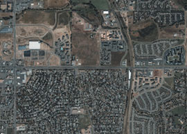
With the use of one-meter satellite imagery and a Web-based field engineering measurement and note-taking kit, 80 to 90 percent of an engineer's need to travel can be eliminated. Photo credit: spaceimaging.com. Many of us are familiar with satellite imagery because of the U.S. military's recent use of it in Operation Enduring Freedom. In fact, Reuters recently reported that the Defense Department was in talks with Space Imaging Inc. to review its contract for exclusive rights to all commercial satellite imagery of Afghanistan and other countries in the region. These high-resolution images, accurate to within one meter, have helped U.S. military commanders plan air strikes on Afghanistan's ruling Taliban and the al Qaeda network of Saudi-born militant Osama bin Laden.
There are, of course, many other uses for satellite imagery. The technology has been used to take amazing photos of some of the world's most damaging natural disasters - from earthquake effects in Bhuj, India, to tornado damage in Fort Worth, Texas. Lest we think satellite imagery is valuable only for military or disaster operations, Space Imaging's IKONOS satellite recently took a detailed color photograph of the largest human gathering in the history of the world, the Maha Kumbh Mela, a spiritual event held every 144 years in northern India. This same technology was even used to locate the site of the CBS television show, "Survivor's Africa Tribal Council." Inquiring minds previewed the one-meter-resolution image that showed a Masai-style tribal village of 10 thatched huts with a circular thorn-bush fence. Had the "Survivor" contestants seen this detailed photo before leaving for camp, the game might have been over a whole lot faster!
All types of industries are enjoying the benefits of satellite imagery: government entities, public utilities, and telecommunications firms to name a few. But are we taking advantage of all the capabilities that satellite imagery has to offer? Not a chance.
Especially for field engineers, satellite imagery can make things more efficient and much less uncomfortable. Why am I singling out field engineers? Because I feel bad every time I see them onsite somewhere, standing too close to traffic, in hot (or cold) weather, scribbling notes on a yellow notepad; they could just as easily be safely ensconced in a cozy office offsite, gathering accurate and complete data in a matter of minutes. No lengthy, miserable, even dangerous trips would be required, no pads of paper necessary. With just a computer (and perhaps a cup of coffee), field engineers can work faster and more efficiently in the comfort of their own office.
Many field engineers already use satellite imagery as a land base for GIS or facility management systems. They usually load it as a backdrop or base map, attempting to readjust one or the other to produce a suitable overlay of the two respective views. While this has been done with some success, the process can be quite costly and labor-intensive if the two networks were not built simultaneously. In addition, storing the image base is space-intensive and can rapidly drain network resources. There is, however, an easier and more cost-effective way to use this imagery. Facility management or GIS companies can put a system into place whereby applications don't need to "talk" to each other. What used to take hours, days or even weeks can happen almost instantly, with the most effective use of available technology being combined with a simple interpretation of what the field engineer sees. In this case, the technology is used to "bring the field to the desktop." By combining engineering experience with the proper tools, much of the expense and complication of merging disparate records and GIS systems can be eliminated.
As the degree of absolute precision is reduced, we can also use less-costly imagery products. Utilizing the imagery strictly for local relative measurements and visual site analyses provides this level of economy. Field engineers are more likely to accept these tools, since they perform the same jobs and make the same decisions necessary to the project, but in a more efficient manner.
Field engineers may also employ satellite imagery with Web-based functionality, but again, my conversations with field engineers tell me they're not using this partnership to its fullest advantage. Given staff reductions and increased pressure to do more with fewer resources, broader deployment of satellite imagery can prevent many in-the-field headaches.
Used properly and combined with the correct set of desktop tools, satellite imagery is the ideal field-engineering implement. When the imagery is Web-based, an engineer can do a simple query on an address or area of interest and, in a matter of minutes, view a detailed birds-eye view of the area. Satellite imagery provides the capability to make accurate measurements and perform detailed analyses where any such work must be done. Additionally, an end-user's computer storage requirements are eliminated. In other words, these tools will enable field engineers to accomplish much more, using far fewer resources.
Geographic information companies have produced a simple solution for field engineers using available satellite imagery and Web-based applications. With the use of one-meter satellite imagery and a Web-based field engineering measurement and note-taking kit, 80 to 90 percent of an engineer's need to travel can be eliminated. Instead, most of the requirements can be documented directly from an office desktop in a matter of minutes - virtually eliminating non-productive travel requirements and saving both time and money.
With one-meter satellite imagery and a Web-based field engineering application in-hand, engineers can see:
• Pavement edges and pavement types
• Buildings and most structures of any size
• Driveways, sidewalks and fences
• Obstructions such as trees, rock outcroppings, ditches and culverts
• Large pad-mounted utility structures, including transformers and cross-boxes
• Utility poles, easily identified from the shadows they project.
I expect that several new trends of Earth imagery will emerge as companies rush to send their satellites into orbit. A little competition never hurts - as long as it brings greater opportunities along with it. In the meantime, I hope I never have to see a shivering field engineer on a busy roadside again! About the Author:
Jeff Barker is president of Kinetic Solutions (St. Louis, Mo.), a company that captures, manages and visualizes geographic information data for utilities and government clients by providing a variety of data management consulting services. He may be reached by telephone at (314) 770-9090. Back |

