| Anthropologist Builds Yucatan GIS to Unlock Secrets of Mayan Settlements
By Kevin P. Corbley 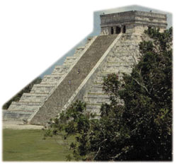 Temple of Kukulkan at Chichén Its. Temple of Kukulkan at Chichén Its.
The Mayan people-with their advanced forms of government, architecture and commerce-continue to fascinate both the scholarly researcher and the casual history enthusiast.
For the history buff, the Mayan experience is typically limited to visiting the ancient city of Chichen Itza, once a center of Mayan culture and now a major Mexican tourist attraction. But for archaeologists and anthropologists, thousands of other sites, some discovered and some not, tell an intriguing tale of the rise and decline of a civilization.
The fact that so many ancient Mayan ruins remain concealed in the dense forests of Mexico, Guatemala, Belize and Honduras convinces scientists that much of the Mayan story will remain untold until these sites are found, excavated and studied.
A researcher at Louisiana State University (LSU) is among a growing number of archaeologists and anthropologists who have turned to GIS, digital mapping and remote sensing technologies to assist in uncovering new sites that may help fill in the missing chapters of the Mayan legacy. Looking for Spatial Relationships
Virtually every aspect of Mayan society is still scrutinized by researchers in a variety of disciplines, but it is the migration of these people from the lowlands of what is now northern Guatemala southward to other parts of Central America, and northward to the Yucatan, that has most fascinated scientists.
From 1000 B.C. to 1500 A.D., these people settled thousands of sites across an area totaling more than 300,000 square kilometers. By finding and studying these settlements, scientists are attempting to determine when and why each particular spot was chosen, and how each fits into the pattern of movement.
Terry Winemiller, an anthropology and geography instructor in the Department of Geography and Anthropology at LSU in Baton Rouge, believes the rain forests of the Yucatan can yield many answers regarding the curious movements of the Maya during their centuries of dominance in these areas of Mexico and Central America.
"I'm using GIS to look at the spatial distribution of the relationships between archaeological features and natural resources such as topography, presence of water, or proximity to limestone," said Winemiller. "The goal is to determine how these physical features might have affected their settlement decisions." When he began building the Yucatan GIS in early 1999, Winemiller selected Intergraph's GeoMedia software due to the flexibility it offered for importing raster and vector data in many different file formats. GeoMedia also provided compatibility with MGE, another Intergraph GIS package already in use at the LSU Computer Aided Design and Geographic Information System (CADGIS) Research Laboratory.
The anthropologist believes the GIS will have a compound benefit in his research. First, it will allow him to develop and test certain assumptions about the relationships between natural surroundings and other aspects of Mayan culture. For instance, Winemiller is working on a theory that control of water resources during the Mayan Classic Period may have led to the rise of a state-like society with an elite ruling class.
Secondly, not only does the GIS serve as a tool to study existing settlement information, it may identify clues that can be used in discovering additional sites not previously found. Winemiller expects the GIS will enable him to discern settlement patterns that are replicated elsewhere in the dense rain forest and can be identified using remote sensing techniques.
"As the program progresses, I plan to use the spatial relationships from the GIS to focus searches using Landsat and Shuttle Imaging Radar imagery," he said.
By building predictive models with GIS technology, Winemiller believes archaeologists may be able to improve their chances of finding undiscovered archaeological sites that "over thousands of years" have been transformed by physical and cultural forces. 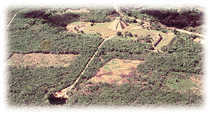 Air photo of the Sacred Cenote and Grand Plaza at Chichén Itz. (courtesty of Dr. Edward B. Kurjack). Air photo of the Sacred Cenote and Grand Plaza at Chichén Itz. (courtesty of Dr. Edward B. Kurjack).
Assembling Data Layers
The GIS includes information on sites in the Northern Yucatan, which the Maya settled from about 200 B.C. until their conquest by the Spanish in 1546 A.D.. Winemiller has spent much of the past year collecting maps and data to populate the GeoMedia GIS for this area.
The GIS basemap was created with 12 mosaicked Landsat Multispectral Scanner (MSS) scenes. Winemiller processed and mosaicked these images using ENVI software from Research Systems Inc. of Boulder, Colo. He also processed a single Landsat Thematic Mapper image of the region around Merida, Mexico, and included it in the GIS as a source of vegetation cover information.
The anthropologist obtained digital maps from Mexico's National Institute of Statistics, Geography, and Information (INEGI) that included political boundaries and some geophysical data. Another government department, the National Commission for Conservation and Use of Biodiversity (CONABIO), supplied digital soil and rainfall maps.
Several other layers of information have come to Winemiller in hard-copy format, and he has digitized them in the LSU GIS lab.
For example, he digitized a hydrologic chart containing the locations of all streams, wells, and other water features. He also scanned-in the boundaries of physiographic provinces that define dominant physical and vegetative features in various parts of the Yucatan.
"One of the most important elements in the GIS is a database of 1338 Mayan sites that were known as of 1980, and included in the Archaeological Atlas of the Yucatan," said Winemiller.
The authors of the atlas provided the list of sites, which range from enormous cities like Chichen Itza to small settlements identified only by trash heaps, in a dBase spreadsheet format with Universal Transverse Mercator (UTM) coordinates. Winemiller transferred the data to Microsoft Excel and wrote a conversion formula to plot the UTM coordinates on the basemap in GeoMedia.
"I then exported the points from Excel to a Microsoft Access database, which is now accessed directly from GeoMedia when ever I want to display the features on the map," he explained.
Winemiller crossreferenced the locations by logging into the National Imagery and Mapping Agency's GEOnet Names Server [www.nima.mil/gns/html/] that lists latitude/longitude coordinates for place names all over the world. Geographic coordinates for major sites outside the region and modern reference points were collected from this site as well.
In the future, when research turns to the use of remote sensing imagery, the archaeologist expects to identify sites not only based upon their spatial arrangements relative to the physical features of the landscape, but also on the layout of structures within the site. For this reason, he had included a detailed map of Chichen Itza in the GIS.
Many sections of the Chichen Itza ruins have been cleared of vegetation, and numerous pyramids and temples have been restored to their original appearance. Scientists have carefully mapped the positions and locations of each feature within the ancient city. Several elements of the city design are common in Mayan settlements.
"Construction methods and architectural features are similar at many sites," he said.
This map was available in AutoCAD format. Winemiller imported the AutoCAD files into the MGE/MicroStation package which was used to mosaic the 12 files. MGE also allowed him to perform a classification of the Chichen Itza map so that structural features were divided into similar functional and stylistic types. The mosaic and classification map were loaded into GeoMedia as another data layer. Accumulating Field Data
Periodically, Winemiller travels to the jungles of the Yucatan to map sites with a Trimble GeoExplorer II GPS receiver. During these field trips, his objective is to pinpoint locations of natural and man-made features. One of these mapping projects focused on the city of Cumtun, a ruin that had been discovered but was never mapped or excavated.
"Because Cumtun hadn't been cleared of vegetation, its current appearance is probably representative of other sites that have yet to be found," explained Winemiller. "And the physical features in the area had never been mapped."
Using GPS, he plotted the locations and positions of pyramids, temples, causeways, natural wells, and limestone outcrops, and then transferred these data to GeoMedia and overlaid them on the Landsat TM image. This has helped him determine how a covered site looks in a satellite image.
"I look at the Cumtun imagery with the overlaid points and say, 'This is the spectral return we get in this situation,'" said Winemiller. Clarifying Mayan Movements
Although Winemiller still plans to conduct another field expedition to gather coordinates of additional natural features in the Yucatan jungle, he is beginning to use the GIS for analysis of data collected to date. In particular, he is using the buffer functions in GeoMedia to determine average distances between major Mayan cities.
"It's pretty clear there are uniform distances between them, and we can use this information to predict where other sites will be found," he said.
He is also using the GIS to create thematic maps showing similarities in architectural styles, ceramic types, and sources of water. In addition, he is importing data on architecture and artifacts recorded in site reports from hundreds of excavations completed in the past century. These data will provide more insight into settlement chronology, prehistoric economic and political interaction between cities, and reasons for expansion into areas of marginal resources.
It is too early to draw any definitive conclusions, but Winemiller believes he is on the right track with the GIS in terms of narrowing his search for undiscovered Mayan settlements, and for providing clues to his theories on the importance of water resources.
"Already the GIS map is revealing holes in our body of knowledge about Mayan locations," he said. "There are large parts of the Yucatan where no sites have been found. Either there aren't any there, or we just haven't found them yet."
Winemiller believes the latter is true because the GIS is identifying many clues in these holes where the combinations of physical features preferred by the Maya exist. Yet these areas have not been explored, and he plans to examine them soon with the aid of Shuttle Radar and Landsat imagery.
In addition, Winemiller is beginning to understand more about the role that water played in the culture. As the population grew, the Maya had to expand into areas of marginal resources, where water was scarcer. They either built large water holding pits, or else they constructed causeways upon which water could be transported.
"The GIS is helping to gather information that may answer a key question regarding the Maya and water-how far away from a water source could they build a city and still survive?" he asked.
Answers to questions like these will shed new light on the Mayan people, their ability to adapt, and their reasons for migrating across the Yucatan. About the Author:
Kevin Corbley is the principal in Corbley Communications Inc. of Littleton, Colo. He may be reached at 303-979-3232 or at [email protected]. Back |

