| i-cubed ImageMap U.S.A. Replaces Guesswork with Reality
By Sue Lenthe Forget squinting to try to bring that flat GIS backdrop to life. With its new ImageMap U.S.A. imagery series, i-cubed offers the first commercially available, comprehensive, bird's-eye view of the national landscape. This landmark effort marks the first time that a 15m resolution, seamless picture of the entire 48 states has been compiled. 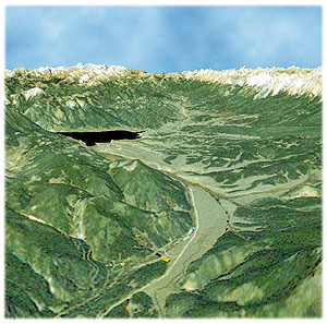 Visualization capabilities make it possible to do virtual tours and fly-throughs of areas of interest to survey the land and view properties and parcels. Here is an image of one such fly-through. Sun angle and orientation of view can be manipulated to tailor the desired end result (image courtesy of LandNetUSA.com). Visualization capabilities make it possible to do virtual tours and fly-throughs of areas of interest to survey the land and view properties and parcels. Here is an image of one such fly-through. Sun angle and orientation of view can be manipulated to tailor the desired end result (image courtesy of LandNetUSA.com).
Construction of the Mosaic Created from more than 450 individual Landsat 7 scenes acquired in 1999 and 2000, this millennium mosaic has broad applications in fields ranging from agriculture to urban planning, telecommunications to flight simulation and even Hollywood productions!
"This is the first time a product such as this has been available on this scale, at this resolution and this degree of accuracy," said i-cubed marketing director Mike Graham. "Our goal was to make the i-cubed ImageMap U.S.A. incredibly easy to use. It is available in any map projection to make sure it integrates with other data layers, and all common file formats, so it can be instantly put to use."
The project took nearly nine months to produce. information integration & imaging, LLC, a Fort Collins, Colo., based geographic data provider teamed with EarthWatch Incorporated, another leading imagery provider in Longmont, Colo., to undertake the challenging venture. "Although we have reached a milestone celebrating the completion of the first generation of the mosaic, we plan to update annually it to ensure the continuing value to the market," said Russ Cowart, president of i-cubed.
EarthWatch handled most of the geometric correction, including collection of ground control from USGS 1:24,000 scale topographic maps, sophisticated photogrammetric aerial triangulation to ensure uniform registration of the images using SocetSet software from LH Systems, and finally the orthorectification of the individual scenes to correct for distortions caused by the terrain and the sensor using software from PCI Geomatics. "That's what lets us make a geometrically seamless product," said Cowart.
i-cubed then took over the fusion, mosaicking and color-balancing tasks. "One of the real challenges was that we had to create new algorithms to sharpen the color bands with the new Landsat 7 broadband panchromatic band," said Yusuf Siddiqui, the lead engineer on the project for i-cubed. "Traditional approaches made the result look artificial," he continued.
Engineers from PCI helped advise i-cubed engineers on new approaches to automating part of the production of a mosaic of such monumental proportions. Each map layer in the series is approximately 250 gigabytes, so processing efficiency was critical to meet the project's deadlines.
The initial map layers include both natural-color and false-color infrared images in both traditional two-dimensional views and the unique hill-shade versions. "We are very excited about the hill-shade blended maps," Siddiqui continued, "because they are so much easier to interpret for most users than the traditional products." "Since we had already created our eDEM 30m DEM product for the entire country, it was a natural fit to combine it with the imagery to create this cool new visualization tool." Applications
With the i-cubed ImageMap U.S.A product, users gain entry to an historic moment, Cowart said. "It's a look at our country at the turn of the millennium, a snapshot in time that details just where we are at this stage in our history."
The mosaic may be useful for consumers and recreational users, but the target audience is the professional user. "The potential applications are incredibly diverse," Cowart continued, "but the common theme is that the incredibly rich information content of the imagery allows the user to make better decisions." For example, some of the uses include:
Real estate and land-planning users can scrutinize population centers and visualize growth trends. Visualization capabilities make it possible to do virtual tours and fly-throughs of areas of interest to survey the land and view properties and parcels. "This is a tremendous product for visualization and understanding of a country's recreational, commercial and public lands," said Craig Harrison of LandNetUSA.com. Critical natural features such as wetlands, vegetation and flood plains are instantly apparent through i-cubed ImageMap U.S.A. imagery.
Utilities planning and pipeline installations can use the map series to see the real lie-of-the-land. They can view actual natural features, roadways, houses and other structures, taking the guesswork out of plotting potential routes. They can now more efficiently and accurately plan new development, optimize utility networks, conduct urban growth studies, manage storm water runoff, plan new road networks, conduct environmental impact studies, and do parcel mapping.
Telecommunications firms building wireless networks can immediately understand population and building distributions. They can then optimize the cost-effectiveness of their purchases of other geographic datasets and thus reduce the design costs of their networks.
Agricultural users can measure field sizes and planted-acre boundaries, plan future crops, identify irrigation and water drainage problem areas, plan efficient irrigation techniques (watershed assessment, erosion and sediment control, channel stabilization, etc.), and plan for future disasters from storm water runoff.
Flight simulation, for both commercial and video game users as well as for the movie and entertainment industries, can now cost-effectively use actual terrain to create more realistic simulations than ever before.
Disaster planners can accurately and efficiently identify and assess hazards and risks (floods, fires, erosion, etc.), identify demographic areas to communicate knowledge about local hazards and risks, implement mitigation efforts and preparedness for natural disaster relief, identify alternative routes and corridors to risk averse areas, and document landscape relationships.
The imagery is currently available on CD or a NAS disk array, although it will soon be available 24 hours a day, Seven days a week via a retail web site. "Another unique feature of the product, besides the resolution, is that the web site will allow a user to order in any quantity, from one square mile to the entire country. We think this will open up the potential user base tremendously," said Cowart.
Regardless of application, Cowart said that the i-cubed ImageMap U.S.A. will help users better understand whatever landscape they are looking at. "With its real-life portrayal of actual features, we think the i-cubed ImageMap U.S.A. can greatly enhance communication by providing an easily understandable common point of reference," Cowart explained. Back |

