|
Introduction
Now in its tenth major release since 1987,
Idrisi provides an extensive set of GIS and image-processing tools available
in a single, integrated package. Backed by a university-based program,
Idrisi provides research-grade tools that are approachable and accessible
to all. The latest version of Idrisi is known as Idrisi32 - the 32-bit
version designed for Windows NT - now in its second release. Systems requirements
include any Windows 32-bit operating system such as Windows 95/98/ME/XP/2000
or NT, 64MB of RAM, and at least 200MB of free hard-disk space. The recommended
level of graphics resolution is 1024 x 768 or higher, with 65,000 colors
or more available on the system.
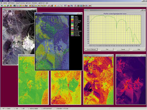 Hyperspectral
image analysis includes routines such as hyperspectral absorption analysis,
using continuum removal as demostrated for Cuprite, Nev. Hyperspectral
image analysis includes routines such as hyperspectral absorption analysis,
using continuum removal as demostrated for Cuprite, Nev.
GIS Modeling
With its strong emphasis on geographic analysis, Idrisi32 provides
several tools for geographic modeling. New with Release Two, Macro Modeler
provides a graphical modeling environment that allows the development
of such models as flow diagrams. Using a drag-and-drop interface, users
can connect more than 100 mathematical, relational or analytical functions
into complex models that can then be saved and edited. Additionally, models
can also be saved as submodels that then become new analytical modules.
As a result, models contain submodels that, in turn, contain still other
submodels. By linking outputs to inputs, dynamic models are also supported.
The result is a process that causes outputs to become inputs in subsequent
iterations. In essence, Macro Modeler is a graphical programming environment
that offers many of the features associated with a programming language.
Distance and Spatial Context Operators
Distance and geographic context play important roles in the analysis of
interactions over space, thus forming an important ingredient of many
geographic models. For distance analysis, Idrisi32 provides a set of operations
that include Euclidian and cost-distance functions, force-vector procedures
for the aggregation and disaggregation of directional forces and frictions,
a least-cost-path procedure, and spatial-allocation routines. With respect
to context, Idrisi32 provides facilities for the analysis of patterns
and textures in the local vicinity of features, and analysis of local
contexts through the filtering and aggregation of contiguous groups.
Decision Support
Idrisi32 is perhaps best known for the character of its decision-support
tools. Foremost among these are multi-criteria and multi-objective decision-making
processes that include a consensus-seeking procedure for weighting criteria,
fuzzy standardization, and an extensive set of criteria-aggregation procedures.
Idrisi32 also provides tools for uncertainty
management. These include error propagation through Monte Carlo simulation,
the evaluation of decision risk as a result of propagated error, calculation
and aggregation of fuzzy sets, and the aggregation of indirect evidence
to support a weight-of-evidence conclusion.
Image Analysis
A major feature of Idrisi32 is its ability to process remotely sensed
images. These features fall into four groups: image restoration, image
enhancement, image classification, and image transformation.
Restoration procedures allow for both radiometric
and geometric correction of images including mosaicking and atmospheric
correction, which permits the integration of high-quality images with
other georeferenced data. Image-enhancement techniques allow for contrast
adjustment, noise removal (using both convolutional filters and Fourier
analysis), and various filtering operations such as edge enhancement.
Idrisi32's image-classification techniques
provide facilities for the computer-assisted interpretation of remotely
sensed images. Unsupervised classifiers employ clustering techniques to
find characteristic land cover reflectance patterns that are later interpreted
by the analyst. A number of supervised classifiers are offered including
Maximum Likelihood (with the option to specify spatial images as prior
probability evidence), Parallelepiped, and Minimum Distance to Means (including
a special distance-normalization feature). New with Release Two is the
Fisher classifier - a classification procedure based upon Linear Discriminant
Analysis (LDA).
Traditionally, classifiers make a difficult
decision about the landcover class of every pixel. However, recent years
have seen the introduction of soft classifiers that express the likelihood
or degree of support for a pixel that belongs to each of the classes under
consideration. The reasons for doing this include an analysis of classification
uncertainty. However, the main application is sub-pixel classification
- the determination of the constituent classes in mixed pixels and their
relative proportions.
Idrisi32 offers extensive sets of soft
classifiers including Linear Spectral Unmixing - a soft classifier that
is based upon the linear mixture model. Idrisi32 Release Two also brings
major enhancements in support of hyperspectral image analysis, including
signature development. Supervised techniques include Spectral Angle Mapping,
Minimum Distance to Means, Linear Spectral Unmixing, Orthogonal Subspace
Projection, and Hyperspectral Absorption Analysis using continuum removal.
Unsupervised procedures are also provided.
Finally, image-transformation procedures
provide a range of important derivative procedures including Principal
Components Analysis, Color Space Transformation (such as RGB/HLS), Texture
Analysis, and an extensive set of vegetation indices such as Tasseled
Cap Transformation and NDVI.
Change and Time-Series Analysis
Idrisi has long had a distinctive set of facilities for change analysis
and time-series analysis. With Idrisi32 Release Two, this capability has
been streamlined and expanded with special tools for image differencing,
change-vector analysis, and regression-based calibration. For time-series
data, a temporal resonance tool called CORRELATE has been developed to
determine the degree of correlation between each pixel over time, and
a designated temporal index.
Special attention has been directed to
the problem of land cover change modeling. Release Two provides a tool
for Markov chain analysis and the modeling of change based upon cellular
automata. Special focus has also been directed to the problem of model
validation, with a set of tools for comparing categorical map data.
Statistics
Idrisi32 provides an extensive set of statistical and spatial statistical
tools including simple and multiple regression, logistic regression, autocorrelation,
pattern statistics, quadrant analysis, and polynomial trend-surface analysis.
Various random-image-generation procedures are also provided to support
Monte Carlo simulation. Special facilities are available for spatial sampling
and ground-truth validation. Release Two has also added a special interface
to the Statistica software system by StatSoft Inc.
Surface Modeling and Geostatistics
Idrisi32 provides an extensive set of surface modeling tools. These include
interpolation procedures such as Inverse Distance Weighting, Triangulated
Irregular Network (TIN) modeling, Thiessen polygons, Trend-Surface Mapping,
and Kriging. Given a digital elevation model (DEM), surface characteristics
such as aspect (slope orientation), illumination (hill shading), curvature,
and slope gradient can be calculated. In addition, special tools are provided
for mapping watersheds, viewsheds, and surface flow patterns (runoff).
Idrisi32's surface modeling techniques include a full suite of geostatistical
tools including Kriging, CoKriging, and Gaussian simulation. These modules
access a modified version of Gstat(c).
Import/Export and Layer Reformatting
Idrisi32 accommodates the importation of all major GIS vector and imagery
formats including ESRI shape files, MapInfo vector files, SDTS, GEOTIF,
DLG, SPOT, LANDSAT, and RADARSAT. Generic routines for ingesting raster
images support an endless variety of formats. Imported files can be rubber-sheet
resampled to fit a specific grid, or can be geodetically transformed through
both datum and projection transformations. Idrisi32's PROJECT module comes
with more than 400 reference system parameter files and instructions on
how to create any other required system. Idrisi32 also supports full two-way
conversion between raster and vector representations. Other transformation
procedures include image subsetting, concatenation, and vector generalization.
Spatial Data Development and GPS Support
The data used by Idrisi32 come from a wide range of sources including
satellite imagery, government-supplied data sets, derived data, and newly
developed map layers. Idrisi32 provides several resident means of developing
new data including an on-screen digitizing and editing facility for vector
data, vector-to-raster (and vice-versa) conversion, and surface interpolation.
Idrisi32 also provides real-time GPS support.
Developer Tools
For the developer Idrisi32 is fully COM compliant, offering comprehensive
access to the system in a manner that is simple to access from programming
environments such as Visual Basic for Applications, Delphi, or Visual
C++. Using the COM interface, developers can integrate new modules and
construct meta-modules that control existing Idrisi32 modules. In addition,
the menu system is fully configurable.
Final Word
In addition to the software, the system includes extensive online documentation
such as a 300-page tutorial complete with 100MB of data.
About the Author:
Ivan Lucena is a GIS researcher at the Clark Labs, Clark
University. He graduated from The National Institute for Space Research
(INPE) in Brazil and is currently researching dynamic modeling tools in
GIS at Clark Labs. He may be reached via e-mail at: [email protected].
Back
|

