| High Resolution IKONOS Imagery Demonstrates Utility for the Transporation Industry
By EOM Staff 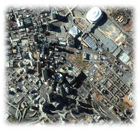 This four-meter resolution, color image of downtown Atlanta, Ga., was collected at approximately 10:30 a.m. on December 27, 1999, by Space Imaging's IKONOS satellite. This image can be used by highway and transportation engineers to evaluate traffic congestion and environmental impact, plan roads through areas of new urban development, and determine evacuation routes in the event of an emergency. IKONOS travels 400 miles above Earth's surface at a speed of 16,000 miles per hour. Credit: spaceimaging.com This four-meter resolution, color image of downtown Atlanta, Ga., was collected at approximately 10:30 a.m. on December 27, 1999, by Space Imaging's IKONOS satellite. This image can be used by highway and transportation engineers to evaluate traffic congestion and environmental impact, plan roads through areas of new urban development, and determine evacuation routes in the event of an emergency. IKONOS travels 400 miles above Earth's surface at a speed of 16,000 miles per hour. Credit: spaceimaging.com
Highway and transportation engineers now have a powerful new tool that will impact the way they make decisions and do business. High-resolution Earth imagery from Space Imaging's IKONOS satellite will help these professionals do a better job of planning, monitoring and evaluating highway and corridor construction projects anywhere on Earth.
"Satellite-based, high-resolution imagery will become indispensable for the transportation industry because it provides the dramatic detail and accuracy needed to precisely execute the largest or smallest of projects," said Brian Soliday, vice president of sales and marketing for Space Imaging North America. "When combined with local GIS and base-map information, IKONOS imagery will offer integrated solutions to planners faced with managing the challenges of America's growing transportation infrastructure."
Space Imaging's high-resolution satellite images, marketed under the company's CARTERRA™ brand name, are state-of-the-art products for the transportation field. The one-meter-resolution panchromatic (black-and-white) and four-meter multispectral (color) images, collected by the IKONOS satellite, have clarity that is the first of its kind in the commercial market. IKONOS images show detailed features such as cars and street centerlines, and can even help pinpoint precise problem areas in sections of a highway or road. Transportation and highway management professionals can use the digital images for:
• assessing the need for new or wider highways
• designing alternate routes during construction projects
• monitoring the progress of construction projects
• evaluating traffic congestion
• creating and updating road maps
• identifying areas experiencing wear to organize resurfacing or repainting projects
• planning roads through areas of new urban development
• determining emergency evacuation routes
"IKONOS provides the macro view for planners to help find the most suitable corridor for construction with the least impact on the environment," said Roger King, director of the National Consortium on Remote Sensing and Transportation at Mississippi State University. "Imagery can be used to help understand the ground terrain beyond the corridor itself to see the potential impact on the environment, watersheds, and the community at large."
IKONOS image products are sold according to customer requirements. Prices range from $30-$45/sq.mi ($12-$17/sq.km) for North America (with a minimum order of $1,000 for archive imagery or $3,000 for new acquisitions) or $75-$112/sq.mi ($29-$44/sq.km) for regions outside of North America (with a minimum order of $2,000 for archive imagery or $6,000 for new acquisitions).
Space Imaging is a leading supplier of visual information products derived from space imagery and aerial photography. The company launched the world's first and only one-meter-resolution, commercial Earth-imaging satellite, IKONOS, on Sept. 24, 1999. Other CARTERRA products are produced from the Indian Remote Sensing satellites, the U.S. Landsat, Canada's RADARSAT and Europe's ERS satellites. Space Imaging also delivers aerial-derived imagery products collected by its own Digital Airborne Imaging System (DAIS-1™). Back |

