| INDUSTRY INSIDER
GIS Landbase: Past, Present, Future
By Jeff Barker and Bob Britton 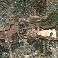 San Diego, CaliforniaÑThis four-meter-resolution color image near San Diego, Calif., was collected by Space ImagingÕs IKONOS satellite on October 7, 1999 The image shows new and existing housing developments, new construction, open space, a highway intersection, and various roads. Imagery such as this could help city managers plan new development, conduct urban growth studies, and manage stormwater runoff; it could help transportation companies plan new road networks and conduct environmental impact studies; and it could help GIS professionals do parcel mapping, create tax-base maps, and do zoning assessments. Photo credit: spaceimaging.com. San Diego, CaliforniaÑThis four-meter-resolution color image near San Diego, Calif., was collected by Space ImagingÕs IKONOS satellite on October 7, 1999 The image shows new and existing housing developments, new construction, open space, a highway intersection, and various roads. Imagery such as this could help city managers plan new development, conduct urban growth studies, and manage stormwater runoff; it could help transportation companies plan new road networks and conduct environmental impact studies; and it could help GIS professionals do parcel mapping, create tax-base maps, and do zoning assessments. Photo credit: spaceimaging.com.
In order to offer customers a better business experience, GIS providers need to stay informed on the latest and most reliable forms of technologies available throughout the industry. GIS Landbase is one area where customers look for new opportunities within a variety of market segments, including utility and field engineering. The Geospatial Information and Technology Association (GITA) recently compiled a list of the top 10 applications and technologies across all market segments that are driving GIS and geospatial technology implementation. The top application mentioned was landbase model programming. GITA discovered that a rapidly growing number of firms are updating landbase accuracy and integrating other systems with automated mapping/facilities management (AM/FM) systems.
This information tells us that GIS companies cannot thrive unless they offer their customers the most efficient technology at the lowest possible cost. This article will provide an insider's look at past, present and future opportunities in GIS landbase. Because this topic is so broad, the authors have decided to focus on three specific areas: commercial data sets, uses of satellite imagery, and software applications. Commercial Data Sets
The past. In the last 15 years, GIS companies have been forced to spend a great deal of money to construct and maintain successful commercial data sets. Landbase data sets were constructed from laborious digitizing efforts, building larger vector and polygonal data sets to create a piecemeal group of service areas. As a result, data sets needed to be built over and over again to meet the individual needs of different applications and organizational requirements. In addition, these sets were hard-wired products that took up a lot of unnecessary space. These data sets were neither time- space- nor cost-effective for clients.
The present. With the widespread availability of GIS landbase, Geographic Data Technology reports that commercial data has evolved into a viable and cost effective alternative for the landbase requirements of numerous industries, particularly utilities. Commercial geographic data sets can address many of the issues of concern to utilities, including data currency, positional accuracy, multiple data formats, landbase development, expansion and maintenance, the and implementation of custom requirements.
Still, the available sources come from various coordinate systems and accuracy conditions, making the construction of a larger composite area from multiple combinations troublesome.
The future. Where are we headed? GIS companies will continue researching new alternatives for data set construction that saves clients time, money and space. These companies have realized that spending a ton of money of building elaborate data sets isn't as worthwhile as thought 15 years ago. In addition, GIS landbase utility mapping will migrate toward image-based, or at least satellite image-rectified base, as opposed to vector intensive data. Today's systems are built to handle large images as well, if not better, than the large vector based data sets in the past. We believe the clich, "a picture is worth a thousand words," works in this case. A picture is worth many thousands of vectors and data relationships within the applications of the past. New data systems will provide images more quickly and more easily, enabling users to apply knowledge and instantly analyze the image opportunities.
In the new millennium, specific data sets for analysis or existing networks can be adjusted to overlay the image, which will allow for integration of the data sets-thus saving time and money for organizations. Even though there are larger available sources of orthorectified images available today, a common coordinate system and scale or resolution is still lacking for larger coverage areas. Satellite Imagery
The past. Here's an interesting fact: the idea of collecting images of archaeological sites from space first began during World War I. When British pilots took aerial photographs of enemy territory, they recognized the plans and features of ancient buildings that were revealed from the airas crop marks. We've come a long way since then.
The present. The GIS industry has just begun to embrace all many uses of satellite imagery. Satellite imaging is becoming a widely known technology, serving a wide variety of markets throughout commercial, government and consumer sectors. According to Space Imaging, the utility industry is one of the largest and fastest growing markets for high-resolution satellite imagery in digital land base mapping. Using highly accurate, digital, orthorectified images, utility companies have a valuable information resource for planning, implementing and maintaining facilities and infrastructure, supporting disaster management efforts, and providing competitive customer service.
The future. Satellite imagery will be key in knitting together the numerous individually tailored, landbase data sets of the past. The cost of building vector overlays will be greatly reduced as imagery becomes more readily available, saving clients time and money. With a common image-based landbase, data sharing will be made more plausible, covering virtually any area of interest while mitigating the coordinate and scale issues of the past.
Key players in the future of imagery use in GIS landbases include companies like ESRI, who has pioneered the management of image based applications, and Space Imaging. In 1997, Space Imaging took a quantum leap forward in the creation and maintenance of today's digital landbase map when they launched EOSAT. The world's first commercial one-meter-resolution remote-sensing satellite opened the door for a multitude of commercial applications in space imagery.
How will these future uses of imagery impact the general industry or municipal engineer? First and foremost, innovations in satellite imagery will create information-rich digital landbases, allowing users to solve real-life problems and make good business decisions-always a key goal for clients. Field users will receive instant and detailed knowledge of job sites exceeding anything available in past vector based systems, without ever having to leave their desks. For example, field engineers spend a lot of time on the road mapping and analyzing data. In a snow storm, traveling is delayed and valuable information is on hold. Imagery will reduce the amount of field time by 80 percent!
Growing competition in the imagery segment should be a positive catalyst that improves the quality of the product and influences future pricing, both of which will benefit end users. Software Applications
The past. ESRI has been, and continues to be, a major influencer in developing software applications for the GIS industry. During the 1980s, ESRI developed a core set of application tools that could be applied in a computer environment to create a geographic information system. In 1981, ESRI launched its first commercial GIS software called ArcInfo. With the Windows operating systems, ESRI evolved their software tools, enabling users to apply the principles of distributed processing and data management.
The present. Geospatial software development now focuses on building tools that are tailored to the design needs of field users like utility engineers. Computer applications have been the primary "image interpreters" for field engineers-they analyze and report the appropriate information. Moreover, the introduction of Web-based applications has been an asset to the growth of the GIS industry.
The future. Geospatial software development will move away from building tools that try to turn high end users into data conversion laborers. The software tools of the future will focus on helping users like utility engineers and designers perform what they already know how to do, in a more efficient manner.
As environments change and industry workers move into a more globally diverse environment, Web-based applications will be used as the primary portal to more and more data users. This will increase the need for applications to focus on presenting data, rather than entering basic information into an application. Simply put, -software companies are finding ways to make images more accurate, so an engineer can look at a picture and use his or her expertise to interpret the information, not a computer.
We believe that Web-based applications will best meet the needs of the utility and other industry users of the future as they are pushed to reduce costs and produce better products and services. Peek Into the Future
For each of the subject areas mentioned, the need to create vector and polygonal data sets for analyzing and summarizing information will remain. However, for the basic landbase knowledge required for a utility engineer, an image carrying information in the simplest form is ultimately best. This is especially true for utility engineering users such as telcos, gas and power utilities, and municipal utilities. Here is a brief recap of GIS landbase opportunities:
• While past landbases were labor-intensive to build, new data sets or existing networks can be adjusted to overlay a satellite image, which will allow for better sharing of data sets and initial data formation-thus saving time and money for organizations.
• Satellite imagery will knit together the landbase data sets of the past and provide a common format picture and controlled base map for the future, giving users virtually all the information they need for any subject area.
• Software vendors should stop building "human intelligence factors" within landbase applications. Users can instantly grasp relevant information from an image without the need for intensive computer analyzing and vector or polygonal overlays.
Ultimately, our clients are our future. The outlook of GIS landbase looks especially good to them. With new opportunities, we look forward to saving clients time, space and money. Here's to the future. About the Authors:
Jeff Barker-With more than 20 years working with CAD and geospatial technologies, Jeffrey Barker is a leader in the geospatial industry. In 1990, Barker founded the Data Management Services (DMS) division of Kenneth Balk & Associates. This resulted in the birth of Kinetic Solutions, LLC in January 1999. Barker holds two degrees in architecture from Washington State University and is a member of GITA, URISA and Open GIS Consortium professional groups.
Bob Britton-As director of Kinetic Solutions™ new Engineering Services Group, Robert W. (Bob) Britton leads efforts to expand Kinetic's engineering assistance applications. With more than 22 years of experience in the geospatial industry, Britton's primary focus has been in program development for telephone, electric and gas utility companies. Britton holds a bachelor's degree in ocean engineering from Florida Atlantic University. About Kinetic Solutions™
Kinetic Solutions™ captures, manages and visualizes geographic information data for its utilities and government clients by providing a variety of data management consulting services, including data integration, data maintenance and collection, software development and strategic consulting. Based in St. Louis, Mo., Kinetic Solutions specializes in customizing information to fit the specific and unique needs of every client. Back |

