| TECH NOTES
MapFusion Brings New Approach & Universal Solution to GIS Interoperability
By Gilles Clément "Geographies," said the geographer, "are the books which, of all books, are most concerned with matters of consequence. They never become old-fashioned. It is very rarely that a mountain changes its position. It is very rarely that an ocean empties itself of its waters. We write of eternal things." - Antoine de Saint-Exupery, The Little Prince. 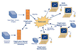 Network-centric ArchitectureÑThis diagram shows how MapFusion components can be combined to form an interoperable, networked geospatial data exchange community. Using MapFusion-based servers and MapFusion workstation software, geospatial data can be shared and disseminated across a network. In this example, dynamically rendered maps are transmitted from a MapFusion server to standard Web browsers using simple ÒhttpÓ requests, while smart map features are transmitted from MapFusion servers to MapFusion workstations or between MapFusion workstations using MapFusionÕs unique geospatial IP-protocol. Network-centric ArchitectureÑThis diagram shows how MapFusion components can be combined to form an interoperable, networked geospatial data exchange community. Using MapFusion-based servers and MapFusion workstation software, geospatial data can be shared and disseminated across a network. In this example, dynamically rendered maps are transmitted from a MapFusion server to standard Web browsers using simple ÒhttpÓ requests, while smart map features are transmitted from MapFusion servers to MapFusion workstations or between MapFusion workstations using MapFusionÕs unique geospatial IP-protocol.
How simple life would be for cartographers and GIS professionals if the author of The Little Prince wrote the rules for world geography today. Unfortunately, geographic data does change, and keeping track of how it changes has become the basis for an entire industry, built around recording geographical features, planning and monitoring resource usage, reviewing ecological changes, and meeting the needs of aerospace, military, and government organizations.
Today, the number and diversity of GIS applications has led to problems more difficult than just the recording of data. The multiplicity of formats in which geographic information is collected, displayed and stored has substantially limited the re-use of important geospatial information across departments, agencies, organizations, and military groups. Simply extracting basic information from foreign data stores is difficult enough. Combining, comparing or collating information from different sources can be nearly impossible. At best, it is a time-consuming and costly task.
Current products address these problems only halfway, converting one type of proprietary format into another. But a novel approach by Montreal-based Global Geomatics may bridge the geospatial data access gap once and for all.
A new product from Global Geomatics takes advantage of object-based technology to deliver nearly universal access to diverse geospatial formats. Known as MapFusion, this product offers an easy way to access, visualize, share and disseminate geospatial data without the need for complex pre-processing or translation. The software can retrieve data in its native form, read it, and then make it available for immediately use. MapFusion's ability to do all these things "on-the-fly" and across IP-based intranets or the Internet means that even non-GIS specialists can reap benefits from geospatial data created by other departments or organizations.
This software transparently converts geodata from its native form (i.e., its source format) into a uniform transient structure (an object model), which is then used to create new map combinations. This procedure allows MapFusion to seamlessly and dynamically merge heterogeneous and distributed geospatial data files into a single map, literally "fusing" maps together. For example, multiple vector or image files - regardless of their source coordinate systems or formats - can be combined to form a single, integrated image. Handily, the product's rendering engine automatically eliminates duplicate or overlapped annotations and labels.
Some of MapFusion's robustness is clearly the result of its roots. This software was designed to meet the rigorous needs of the military establishment. Its ease of use and quick installation are directly related to the ad hoc nature of military operations, typified by frequent rotation of personnel, the need for information-sharing between coalition partners who possess diverse data sets, and the requirement for an integrated, "on-the-fly" view of battlefield resources.
MapFusion services the commercial market equally well. Besides complying with the majority of geospatial military standards, MapFusion supports popular GIS business packages from ESRI, Informix (an IBM subsidiary), Intergraph, MapInfo, ObjectFX, Oracle, and Virtual Prototypes. It reads data from proprietary and open-GIS file formats that include MrSID, ECW, GeoTIFF, Shapefile, Tab/Map, GRASS, SDTS, and TIGER. While most software reads only four or five different types of data, MapFusion provides on-demand access to 80 percent of today's geodata formats.
MapFusion offers standard cartographic navigation functionality such as panning in all directions, zooming in, zooming out, and querying data attributes. It also includes a powerful map-authoring tool that allows users to assign rich symbology - with either fixed or geographically proportional metrics - to any geospatial coverage including colors, line widths, text annotations, follow-through symbols for linear features, and complex fills for areas. Users can assign visibility thresholds to coverage or to symbology, allowing map symbols to change dynamically as one zooms in or out on the image.
MapFusion can be used to publish pre-authored maps that are accessible through standard Web browsers such as Microsoft Internet Explorer or Netscape Navigator. The MapFusion viewer interface does not require a plug-in download.
This product has other bells and whistles as well, including its own "Napster-like" ability to find, retrieve, and share files. MapFusion can search for geospatial data on any file system, hard drive, CD-ROM or networked file system. It can also search across an intranet for geospatial data sets that are owned or shared by other MapFusion users. Once it detects a geospatial data file, MapFusion can extract key characteristics (meta-data) and display all relevant information in a convenient list. This capability makes it extremely easy for users on a network to locate the data they need. Underlying Technology
The foundation of MapFusion is the Open Geospatial Datastore Interface (OGDI) and the Geographic Library Transfer Protocol (GLTP). Developed in collaboration with defense scientists at the Canadian Department of National Defence, OGDI is an application program interface (API) that enables any software application to easily access heterogeneous geospatial data sources. GLTP provides a unique, IP-based data transfer protocol that, when combined with OGDI, allows complete interoperability of distributed and heterogeneous geospatial data sources. MapFusion uses OGDI to access local data sources, while GLTP is used to establish networked exchange and dissemination of geospatial data.
MapFusion Components
MapFusion is comprised of server, workstation and adapter software. Geospatial data dissemination and dynamic map rendering services are handled by MapFusion's server software, which processes requests from both MapFusion workstations and from standard Web browsers. MapFusion Server can also act as a central, metadata repository. MapFusion Workstation is user-oriented software that provides easy access, sharing and visualization of geospatial data sets. Adapter software is used to normalize geospatial file formats into a uniform data abstraction, which can then be easily manipulated.
MapFusion operates in a broad variety of computing environments including Microsoft Windows 98/NT/2000, Sun Microsystems Solaris, and Linux. Summary
For GIS professionals today, this approach by Global Geomatics means that users can save time, money and effort. They are no longer required to build this sort of software in-house. While other tools offer data "translation" capabilities, they still leave users with a daunting conversion task. There are also organizations focused on getting numerous companies to agree on a common format or interoperability process. But building consensus among many vendors and many subcommittees takes time and can leave years of legacy data in the dust. MapFusion supports geospatial information that has already been created, and it furthermore offers a solid bridge to the future. About the Author:
Gilles Clment has more than 20 years experience in the fields of IT and geomatics. He has received several awards for developing geomatics software and for the progressive use of geo-technologies. Prior to founding Global Geomatics, he was a consultant for Hydro-Qubec. He may be reached by telephone at (514) 279-9779. Back |

