| Updating Digital Geo-data with High-resolution InSAR Data
By Markus Rombach Introduction
Triggered by increased demand from users and the need for shorter data cycles, updating digital geo-data has become a fast-growing market. InSAR is especially well suited for this task because of its independence from weather conditions and its effectiveness in mapping equally well in daylight or at night. Collecting data during an InSAR flight can be performed in a timely manner without incurring great cost. This article discusses the updating process using high-resolution InSAR data for ATKIS¨ DLM25/1. ATKIS¨ is the topographic-cartographic information system used by surveying authorities in the various states of the Federal Republic of Germany. DLM25/1 is the first digital-landscape acquisition model to be generated on a scale of 1:25,000. 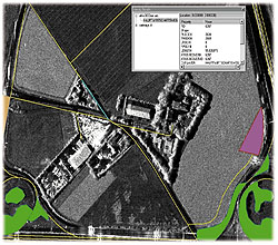 Figure 7: Updated ATKIS®-data, overlaid on the SAR ortho-image. Figure 7: Updated ATKIS®-data, overlaid on the SAR ortho-image.
This updating process was carried out over a 30-square-kilometer area close to Munich, Germany. This mostly urban landscape was selected because of its wide variety of recent topographic changes, most of which have taken place due to new construction activity. Input data for the updating process were primarily SAR ortho-images with a spatial resolution of 0.5m x 0.5m.
This article further describes the updating process and presents the suitability of using high-resolution InSAR data in this regard. It also provides an overview of Aero-Sensing's airborne SAR system AeS-1, details the updating process, and defines the achieved results with an outlook toward future activity.
The AES-1 System
Early in 1996, Aero-Sensing Radarsysteme GmbH began to design and build a high-resolution x-band interferometric SAR that they chose to call AeS-1. After its first test flights in August 1996, the system became operational in October of the same year.
The AeS-1 is configured as a two-antenna, single-pass interferometric SAR, with a ground resolution of up to 0.5m x 0.5m, and a height accuracy of up to five centimeters. The system consists of both a ground segment and a flight segment. Figure 1 shows the AeS-1 flight segment, while Figure 2 shows the radar antenna construction as installed on a Rockwell Turbine Commander. The block diagram (Figure 3) shows the ground and flight segments of the AeS-1, as well as its components. Figure 4 shows the standard InSAR flight geometry. Antenna Construction
The ground segment consists of a laptop computer for flight planning, a data transcription system, the SAR- and interferometric SAR (InSAR) processing facility, an archiving management system, and a GPS ground station. The flight segment consists of radar antennas, a transmitter/receiver, a clock generator, a control computer, a disk array unit for data recording, and a flight control system.
Thanks to its compact design, the AeS-1 system can be installed on small aircraft such as the Rockwell Aero Commander 685 or the Rockwell Turbine Commander. The AeS-1 is a fully automatic system. Because the flight control unit offers a display where the real track and its deviation (relative to the nominal one) are indicated, the pilot need only follow the tracks as displayed. No co-pilot or secondary operator is required. Updating ATKIS®-DLM25/1 Data
As mentioned above, the input data used in this updating process were SAR ortho-images with spatial resolution of 0.5m x 0.5m (Figure 5), captured in x-band frequency. The corresponding DEM, which was generated by means of interferometric technology, was used for georeferencing of the imagery data only.
As the EDBS (Uniform DataBase Interface) software environment - normally used for the updating process - was not available, the actualization was carried out using standard GIS software. The existing ATKIS® data was therefore converted into the corresponding GIS file format, while each object group was represented in a separate file.
After all input data constituents were ready, the SAR ortho-image was analyzed compared to its positional accuracy by using official digital cadastral data (DFK data) with an accuracy rating of plus-or-minus three centimeters and more than 100 reference points. The result of this position check showed that the position quality was of a homogenous and good quality within the entire image mosaic, and furthermore not dependent upon different object classes. The mean positional accuracy was about plus-or-minus 1.12 meters, while ATKIS¨ data acquisition requires plus-or-minus 3.0 meters.
Before starting the updating process, the imagery was classified using a semi-automatic image classification algorithm. This provided simple recognition of changes while later overlaying the SAR ortho-image with the ATKIS® data yet to be updated. The image classification algorithm developed by Aero-Sensing is a "multilayer perceptron algorithm" based upon neural network technology. As the classification results cannot differentiate between all object classes contained within the ATKIS® data, only main object classes and groups were determined, e.g., built-up areas, agricultural areas, forests, and bodies of water. Figure 6 shows a part of the classified area, merged with the corresponding SAR ortho-image. The comparison between classified data and ATKIS® data showed that areas where changes occurred were easily determined. Positional differences were caused mostly by the ATKIS® data itself in relation to the process of map generalization, as for this area the data sources were official topographic maps in a scale of 1:25,000.
The updating process was performed separately according to different object groups (transport, settlement, watercourses, vegetation, and administration), while each class had its own layer for objects to be either removed or included. Before starting the updating process, a detailed interpretation key was produced in order to allow easy recognition of those ATKIS® objects that were included in the test site. Actual object updates, by means of their geometry or attributes, were based upon visual interpretation and topologically correct on-screen digitizing that used GIS software and SAR ortho-images, ATKIS® data, plus automatic image classification. The entire updating procedure was closely related to the regulations of the official ATKIS® object catalogue.
The object group titled "Transport" contained all sorts of traffic-related items, including road and railway networks. Streets that differed from each other due to attributes and class, but not necessarily due to appearance, were not always easily distinguished. This factor was often determined by the importance of the road, which is greatly dependent upon the width of the street. Motorways and junctions were more easily recognized due to their specific structure and appearance. On the other hand, new roads were easily interpreted and included into the data set by means of their geometry, shape and position. Different road pavements were determined by using the gray value in which a street appeared in the SAR ortho-image. Streets shown in light gray were mostly of rough surface and therefore not paved tracks or trails. Paved roads appeared in dark gray or black due to their smooth asphalt surface. Railway tracks appeared in light gray due to their gravel-bed construction and geometrically straight lines. Water surfaces appeared as uniformly dark areas due to their mostly smooth surface. In this test site, nearly every lake or pond was recognized. Rivers, brooks and channels were not contained within the test site.
The object group titled "Settlement" contained different classes of built-up areas, e.g., residential, mixed-use or exhibition areas, and industrial parks. Built-up areas were easily separated from agricultural or forested areas. Different classes of built-up areas were determined due to the shape and size of the buildings, broken down into industrial or residential blocks. Object classes that were defined only thematically by specific features - for example, "Recreation ground" - could not be easily distinguished from other object classes of the settlement object group. Despite this element, other specific object classes - for example, "Open cast mine" - could be determined due to their embankment structure characteristics. Settlement boundaries were determined on a basis of natural real estate boundaries, which were easily seen in the SAR ortho-image by observing such structures as gardens, walls or traffic lines.
The remaining agricultural fields, open areas and forested areas were condensed into the object group titled "Vegetation." The experience of previous interpretation showed that, in general, different vegetation objects were easily determined through the use of InSAR. In particular, forested and agricultural areas were easy to differentiate. Even different classes such as coniferous or deciduous forests were visible, if very-high-resolution InSAR data (better-than-one-meter resolution) was used. Once again, specific object classes that appeared specifically by shape and texture were easily recognizable. Examples include tree nurseries, parks and gardens. The object classes titled "Impervious constructed areas" and "Wasteland" were determined due to their texture. It should be noted that the object group titled "Administration," which contains administrative boundaries, was not updated.
Further information about this updating process, with detailed descriptions due to several object groups and classes, are presented in the project statement. Figure 7 shows the ATKIS® data overlaid on the SAR ortho-image. Figure 8 shows the update result for a portion of the test area.
Quality control of the updated objects was performed using a detailed field control, in which objects were controlled due to their thematic content and class affiliation. Only a few geometric controls were performed, as the position accuracy of the InSAR data was checked before beginning the updating process. These geometric controls show that most objects were digitized with their appropriate boundaries and corresponding estate boundaries. The object classes and thematic control showed that almost all objects that appeared in the project area were interpreted correctly. Misinterpretations occurred if objects were determined and classified only due to specific characteristics not visible in the SAR ortho-image, or from remote sensing imagery in general. Conclusion
This project illustrated the suitability of updating digital geo-information data on the basis of high-resolution InSAR data, as derived from the AeS-1 airborne InSAR system. A predominant number of objects covering the test site were updated with a high level of thematic reliability. In the future, an easier updating process is further guaranteed when repeated flights, with constant data-quality output, would allow change detection and visualization to occur automatically. In relation to the weather-independent nature of InSAR data acquisition, this updating process can be performed in a timely and cost-efficient manner. About the Author:
Markus Rombach is the director of business development and product management for Aero-Sensing Radarsysteme GmbH, Oberpfaffenhofen, (D-82234) Wessling, Germany. He may be reached by telephone at (49) 8153-908809, or via e-mail at [email protected]. Back |

