| Creating and Managing Photogrammetric Data: No one has all the answers!
By Robin Sheehan How Did We Get Here?
There is no definitively correct answer when it comes to solutions for managing and exploiting spatial data. Throughout the 1980s and early 1990s, in our naivete, we had to put up with the false promise that this Geographic Information System (GIS), or that Image Processing (IP) system, or some other Digital Photogrammetric Workstation (DPW), was ready to be hauled off to immediately begin enriching our lives. How wrong we were! Like one's grandfather talking to his now adult grandchild, we can look back and say, "My, how we've grown!" 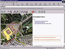 Figure 3: Demonstrating the direct read of the Earth Resource Mapping's ECW compressed-data format into the Laser-Scan environment Figure 3: Demonstrating the direct read of the Earth Resource Mapping's ECW compressed-data format into the Laser-Scan environment
The New Competitive Reality
What began quietly a decade or more ago has now become a revolution. Markets around the world have changed dramatically, as has the technology available to service those markets. Competitive pressures now demand efficiency and effectiveness from a wide selection of organizations. Firms have had to quickly adapt to market pressures as well as innovations discovered by their competitors. Large, monolithic organizations have been forced to slim down and seek network alliances with others, instead of outsourcing activities best performed by someone else. Does this all sound familiar? Our spatial industry has escaped neither the "new competitive reality" nor the driving force of globalization. Some of these organizations have learned to react accordingly. Cooperation, rather than "corporation," is now the key to survival. The Great Technology Convergence
For many requirements, no single organization can now claim to have all the answers. There are many precedents wherein vendor companies rely on each other, working together to provide a total solution for data exploitation and mapping. Recent technological integration of GIS with DPW and IP systems illustrates a long-awaited response to needs within the spatial data industry. As prominent industry alliances arise - focused on appropriate integrative solutions - monolithic GIS, as it was perceived a decade ago, is quickly vanishing from the landscape. The technology moves on, adapting to significant changes in the marketplace that require more complex solutions and more complex data modeling. These are all elements that become more and more difficult to address with disparate technologies than those traditionally operated in benign isolation.
This factor is demonstrated in a number of alliances, including cooperation - and software integration - between such organizations as Laser-Scan (LAMPS2 GIS), LH Systems (SOCET SET®(1) DPW), and Earth Resource Mapping (IP). In this example, Laser-Scan is taking the initiative not to reinvent already well made wheels, to enhance solutions available to the end-user - offering something more comprehensive than was previously available - and to generate synergistic relationships with other technologies and organizations to enhance their business. GIS and Photogrammetry: The Best of Both Worlds
The state of the art for DPW is based mainly upon interactive digitization, creating vector data with 3D coordinates, and a certain level of attribution. However, the captured data is not topological and generally has little in the way of "management" within the DPW. On the other hand, storage and access is what characterizes GIS, as well as basic management and manipulation of what is essentially 2D data plus attribution.
The traditional model for DPW data capture and its subsequent incorporation within a GIS environment is inefficient and flawed. It is based upon the following elements:
1. Input and registration (DPW)
2. Capture of 2.5D vector data (DPW)
3. Exportation of vector data to a common transfer format (DPW)
4. Importation of vectors into a GIS environment
5. Construction of 2D structure and topology (GIS)
6. Validation of data for geometric or topological errors (GIS)
7. Exportation of data for importation back into DPW, if errors exist
8. Identification of errors and subsequent manual correction (DPW)
9. Repetition of Steps 3 through 7 until data integrity is assured.
Figure 2 illustrates a different model. This is the model inherent within the integrated solution based upon LAMPS2 and SOCET SET. In this integrated data exploitation environment, data and knowledge acquisition, 2.5D topology generation, data validation, and data utilization are not disparate processes. They sit together in the same data-generation session, making full use of both the DPW and the GIS.
Topology is built and maintained - and validation implemented - on a dynamic basis at the very moment of capturing or editing data objects. The DPW and GIS share the data generated and edited both dynamically and instantaneously. The data appears in both the LAMPS2 and the SOCET SET graphics windows via the LAMPS2 Object Oriented Spatial Database (Figure 1). The Driving Forces
The U.S. Army Topographic Engineering Center (TEC) has been a driving force for the integration of LAMPS2 and SOCET SET; Laser-Scan and TEC entered into a formal cooperative research agreement in 1998. This integration was based largely upon a requirement for the management of x, y, and z coordinate objects, plus a 2.5D topology capability, both of which are met in the Laser-Scan object-oriented spatial environment. This agreement was also based upon the obvious working benefits of having a close coupling between DPW and GIS. The result is an essentially real-time, topological 2.5D mapping and database capability.
It should be noted that the situation described above is not unique to Laser-Scan and TEC. In Ordnance Survey, over the past two years, a number of initiatives have led to an integrated LAMPS2/SOCET SET DPW solution - a move seen as vital for improving data maintenance and updates within the organization, and also providing for the future exploitation of opportunities.
The U.S. National Imagery and Mapping Agency (NIMA) is also evaluating a LAMPS2/SOCET SET solution along Vector Product Format (VPF) flow lines for structured data products, notably the Feature Foundation Data (FFD). The focus here lies heavily on the capacity for real-time object-oriented data validation, one that ensures consistent and correct z-data capture. For example, this would include detection of spikes within the data, height-clearance checks for bridges, slope consistency, and also point-in-area consistency. GIS and Image Processing: The Best of Three Worlds
Today, most GIS systems have the ability to perform such basic image-handling tasks as rectification and display as an image backdrop. Laser-Scan's object-oriented GIS system architecture can handle large raster and vector data sets in a seamless manner. Therefore, integrating image processing with this technology offers escape from the constraints of image scenes, while map data can escape the sheet-boundary mentality of data management.
Major divisions between GIS and IP are based mainly upon the following elements:
• Fundamental differences between raster and vector data models
• Fundamentally different data handling and analysis processes in IP versus GIS
• Historically different bespoke hardware requirements
• Cultural separation of the two disciplines.
Fifteen or 20 years ago, a technological convergence was considered extremely desirable, if not an actual requirement. Ten years ago, people finally got around to writing about it, saying such things as, "The integration of image data into GIS is one of the great ideas whose time has come... Remotely sensed images have been shown to be a cost-effective means for the updating of GIS data."
These divisions are being addressed out of the convergence of these two cultures and that of the base-technology involved, as well as being driven by user-requirements as noted below:
• Environmental applications of GIS are commonplace, and require imagery for enhancing map data
• These applications frequently require results from IP, e.g., image classification
• Vector data from GIS is commonly required in IP exercises for context or correction
• Basic hardware and software requirements now have common ground within GIS and IP
• Basic hardware and software now facilitates 24-bit image handling in the GIS environment, among others
• Convergence and commonality of user requirements exist within the two cultures
• These two technologies are recognized to provide a far more powerful tool together, rather than independently.
The benefits of integrating DPW and GIS are discussed above. In particular, this means faster generation of useful information to the end-user - such as digital terrain models - and the combination of this information with whatever vector data might be available.
IP is also an important part of the jigsaw puzzle. It would be beneficial to bring to bear IP capabilities to extract and derive more complex data and knowledge pertinent to a situation, such as environmental data. Again, it may be beneficial to integrate IP with the DPW - in order to borrow the 3D data perspective - adding further value to IP-generated information. Alternatively, specifically enhanced imagery from the IP system may make it easier to generate more accurate 3D-vector infrastructure and environmental data in the DPW, for example, with features that were previously not identifiable within the scope of standard imagery.
To bring IP, DPW, and GIS all together into one single, integrated environment is a powerful synergy. This concept breaks through many of the barriers to speedy, accurate, and effective generation of information that can be passed along to analysts and workers on the ground. Making It Available
We are now down to another key issue - the access and dissemination of that data. It may do well to generate the appropriate information and integrated "image mapping" products in an efficient manner. But workers on the ground are increasingly requiring these data, workers who may not own the necessary equipment or the money with which to buy it. Yet they require the first drafts of data and mapping to reach them within just a few hours of notification of a requirement, e.g., in circumstances of crisis/disaster management. Key decisions must be made in real time. Open GIS and Accessibility
Enter organizations such as the Open GIS Consortium, plus successful projects such as the Web Mapping Test Bed, and things begin to look quite different. Laser-Scan is one of many participants in the Web Mapping Test Bed, an ongoing collaborative initiative that explores standards in Web-based spatial data and map dissemination. Results so far are encouraging, and there are a number of examples of Web-based solutions that grant a user access-on-demand to vector data and imagery from multiple data providers, all through a standard Web browser. This prospect raises the possibility of divorcing some end-users from the twin responsibilities of data preparation and analysis, and also the associated investments in hardware and technical expertise. Additionally, it raises the requirement of cooperatives being set up between the organizations that possess the expertise, equipment and data, in order to make available data, mapping and imagery for specific requirements. Image Compression and Accessibility
Imagery has various constraints attached to it, one of which relates simply to storage size. Images are big - relatively speaking - and this circumstance has implications for bandwidth, speed of access, performance during zoom/pan operations, and also local disk requirements, if downloading is an option. For this reason, high-resolution data and the Internet have never been all that closely associated. One answer to this problem is based upon Earth Resource Mapping's Enhanced Compressed Wavelet (ECW) technology. This allows imagery to be viewed at full resolution, but stores it as an ECW file many times smaller than its uncompressed alter-ego.
Laser-Scan now has a demonstrable, direct-read capability with ECW (Figure 3), both on the desktop and on the Web, and products such as this derive benefit from fast access and high performance during ECW read operations. Is GIS Dead?
Over the past two years I have been asked more and more often, "Is GIS dead?" Clearly the answer is, "No!" But I believe that GIS, as it was perceived a decade ago, is decidedly extinct in that form. It has moved on as a technology, evolving through significant changes into its current marketplace environment. This evolution continues, both in real terms with the convergence and integration of technologies, and conceptually as we talk less about GIS and more about integrated "toolkits" that get the job done. The message from the user community to the vendor community is as clear as it has always been, "Embrace change, adapt to it, and evolve."
With this synergistic philosophy, it is not only possible to meet today's needs, but also to provide a framework for users who can accommodate future advances in related spatial information technologies. About the Author:
Robin Sheehan is business development manager at Laser-Scan, Cambridge, England. For the past eighteen years he has worked with spatial data, both as an environmental scientist in the British Oceanographic Data Centre and the UK Met Office, and as a consultant in the vendor environment with both Software Sciences and Laser-Scan. He may be contacted by telephone at (44) 1223- 420414, or via e-mail at [email protected]. Back |

