
|
 |
|
A
New Star in the Radar Firmament: STARplus Set to Broaden Use of RADAR Intermap Technologies, known for its developments in airborne radar mapping, is showing a new product to the market – one that has the potential to overcome much of the market’s hesitancy in embracing the use of radar data, and also offers the possibility of expansion into much broader markets.
STARplus is a practical combination of Intermap’s interferometric radar data and Landsat optical data. The resulting image product exhibits the best of both worlds, using the Landsat data to "colorize" the fine-resolution (2.5m) radar image, and the radar to "sharpen" the coarse-resolution (30m) Landsat. As a bonus this product is relatively inexpensive, using the $12-per-square-kilometer STAR-3i archive data and low-cost Landsat Thematic Mapper™ data – a fact of great interest to current and potential users of the much higher priced high-resolution satellite data. It is still early in the marketing cycle of this STARplus product, but customers who have seen it have been "really blown away," according to Intermap senior accounts representative, Marc Wride. STARplus Development "This is an old idea, but one that has new operational relevance," said Intermap’s chief scientist Bryan Mercer. Pan sharpening of Landsat and other multispectral optical imagery has been around for a long time, as have transformation techniques (such as the IHS transform) used to merge and display different types of rasterized data. These techniques enhance textural and intensity information in remotely sensed images, providing more interpretable information for mapping, analysis or further processing. The STARplus product idea arose while Mercer was trying to develop a solution for an entirely different application, using Landsat as a complementary product for automated delineation of water bodies on radar. Remembering some previous IHS transform work done by the company in conjunction with the Canada Centre for Remote Sensing that used SAR-580 radar and Landsat data, Mercer and his team came up with the current STARplus concept, initially called "SAR-sharpening." When an orthorectified, single-channel IFSAR (STAR-3i) image with a 2.5-meter pixel was merged with a three-band orthorectified Landsat TM scene with a 28.5-meter pixel, this group was surprised by what they saw. The end-result preserved the intensity and textural information of the fine resolution radar image, but modulated it with the multispectral content of the Landsat data. It was both visually pleasing and loaded with information. STARplus can be produced using Landsat TM, eTM or even MSS. Any three-band combination (blue, green and red, or middle-IR, IR and green are the standard choices) can be selected, but everything must be orthorectified prior to the operation. Both Landsat-5 and -7 data have been used, but the major cost savings comes from the use of Landsat-5, available from the GeoCover program (Earth Satellite Corp., under contract to NASA). GeoCover provides digital, high-quality, low-cloud-cover Landsat 5 imagery (about 185 x 185 km) at a very low cost per scene. GeoCover-Ortho products are positionally accurate (50m RMS) orthorectified Landsat TM and MSS images, available for most of the Earth’s land areas, at a spatial resolution of 28.5 meters. At about $600 per scene, they are an inexpensive source of orthorectified multispectral data. Scott Bennett, director of business development for ImageLinks Inc., said that they have used ImageLinks’ own fusion technology to combine Intermap’s STAR-3i data with Landsat-7 data, and are excited about the results. "The high resolution DEMs and the radar sharpness provide the best of SAR technology, while our new adaptive fusion code preserves the source radiometry of Landsat-7 in this product. You get the best of both with the STARPlus product," he explained. ImageLinks, an image processing company based in Melbourne, Fla., is a reseller of Intermap products and will be one of the vendors producing STARplus, in addition to Intermap itself. In fact, because many image-processing software packages have such data fusion capability, most STAR-3i data users can produce the product themselves, something encouraged by Intermap according to Garth Lawrence, Intermap’s vice president of marketing. STARplus is a product with the visual appeal that radar, for all its accuracy and high information content, has never had. According to Amy Daniels, Intermap’s GLOBAL Terrain data manager, "SAR is scary...people don’t know what to do with it." She added, "People are used to color," and furthermore explained that they are predisposed to look at and work with a color product much longer than one in gray tones. The human eye can recognize millions of different colors as compared to only hundreds of gray tones or fewer, so this analysis makes sense physically. Adding multispectral information to the radar image enhances subtle color differences not seen in the SAR image alone. In fact, interpretation of vegetation classes and other land surface attributes is the subject of ongoing research at Intermap and elsewhere. Intermap Background In an article last fall in the Wall Street Corporate Reporter, company president and CEO Brian Bullock described Intermap as "the company with the commercial capacity to meet world demand for accurate, low-cost digital elevation model (DEM) products." Using their STAR-3i IFSAR airborne radar system, Intermap can map very large areas accurately, rapidly and in adverse (cloudy or dark) conditions, generating both DEMs and orthorectified images (ORRIs) simultaneously. To date, nearly a million square kilometers of IFSAR data from 23 countries resides in the company’s GLOBAL Terrain database. Intermap acquires data for custom projects, but also has developed a GLOBAL Terrain online data store where radar data products are regularly archived. Having begun acquiring its coverage piecemeal across the United States, GLOBAL Terrain is now capturing entire countries at one time via their NEXTMap series of national high-resolution mapping programs. For example, Intermap is currently completing coverage of most of the United Kingdom through its commercially funded NEXTMap Britain program. Radar Markets Broaden with STARplus Intermap sees STARplus as its entry into much broader radar markets. For example, STARplus is expected to play a significant role in the rapidly expanding visualization market. "As better elevation and optical data become available, visualization technology is producing much more realistic results," Marc Wride explained. Continuing advances in computing power and cheaper data storage allow data-intensive solutions like STARplus to be feasibly implemented. One obvious user is the aviation sector, particularly for flight simulations around "terrain-challenged" airports. For a number of years, pilots have been trained to land aircraft using simulations of airports and their surroundings, using rather cartoon-like graphics. Last May, Intermap and DigitalGlobe (formerly EarthWatch Inc.) announced a contract with NASA to supply high-accuracy mapping data for an aviation safety project. STAR-3i DEMs are being generated for 11 mountain passes and their surrounding areas in heavily traveled air routes throughout Alaska. Precise three-dimensional, "virtual reality" images of the terrain will be displayed in aircraft cockpits as pilot aids for navigation in poor weather. Called Synthetic Vision, this system will combine Global Positioning System (GPS) signals with the highly accurate terrain information to give pilots an exact representation of the Earth’s surface for times when visual contact with the airport cannot be made. Eventually this technology will be certified for public use, according to Del Croom, a NASA researcher investigating database issues for synthetic vision systems. Use of the colorized STARplus product in this application not only will improve flight training, but also visualization of actual landings in bad weather. Plan view uses for STARplus (i.e., image maps) are potentially as important as uses based on perspective views. Thematic maps (such as standard topographic maps) contain valuable thematic and elevation contour information, but have limitations for users requiring information on other "themes," or those who need more up-to-date information. From air photo mosaics and orthophoto quads from aerial photographs, image maps have evolved into satellite image maps (like the GeoCover series) that can be interpreted by image map users for their own needs. However, at the high resolutions required by many users, image maps are expensive to produce; at lower resolutions, they have limited applicability at a local or regional level. With the highly interpretable, color STARplus products as image maps, costs come down and large-area coverage is much more feasible. Scott Bennett of ImageLinks said, "We are excited about having the geospatial accuracy plus the information content," and he furthermore sees the STARplus product as a valuable new derivative product for extracting vectors for such "edge features" as roads, property lines, transmission lines, and field boundaries. Kevin Little, director of business development in Intermap’s Denver office, believes that STARplus opens up a new market in the crop insurance sector. Airborne and satellite remote sensing has been used for years to evaluate crop insurance claims, but the process has heretofore been expensive and laborious. Using the orthorectified SAR base to provide basic information on field boundaries and infrastructure, various dates of Landsat imagery can be layered on top for rapid evaluation of temporal change. What is (or is not) being grown in the fields of interest can then be interpreted manually or automatically and checked against insurance claims, all at a much lower cost to the insurance industry. Watch for It A new twist on traditional methods can sometimes produce something truly worthwhile. Intermap has taken low-cost, low-resolution Landsat data and given it an "edge" with the addition of their high-resolution radar data, as well as increasing the interpretability of STAR-3i radar data. Its global availability increases daily. Watch for it soon!u About the Author: Diane Coleman is a senior consultant with Earth Observation Services in Calgary, Alberta, Canada. She may be reached by telephone at (403) 242-2103, or via e-mail at [email protected]. |
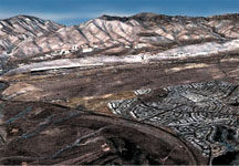 STARplus
perspective view of Morrison quad area near Denver, Colo. (using Landsat
Bands 3, 2 and 1).
STARplus
perspective view of Morrison quad area near Denver, Colo. (using Landsat
Bands 3, 2 and 1).