
|
 |
|
Puget
Sound Offer LIDAR Data Free on the Web With its untold applications, highly detailed Light Detection and Ranging (LIDAR) data has the potential to benefit many users in government, industry and science sectors. To capitalize on this potential, the Puget Sound LIDAR Consortium (PSLC) has been using this advanced technology to collect extensive digital Earth surface data for the Puget Lowland, and making these data available for free on the Internet. For more than two years, government agencies, private companies and educational institutions in the region have used these public domain, wide-area LIDAR-based maps for a variety of purposes, from geological hazard determination to transportation planning to salmon habitat preservation.
In 1996 the Public Utility District (PUD) for Kitsap County, located in northwestern Washington, recognized the need for accurate topography information to evaluate groundwater sources and plan waterlines in the region. The PUD started by mapping Bainbridge Island, Wash., a 28-square mile island directly across Puget Sound from Seattle. The Kitsap County PUD hired a survey firm that used LIDAR, which produced highly detailed elevation data significantly faster and more affordably than conventional survey methods would have done. For a heavily forested area, LIDAR also promised a more accurate and cost-effective representation of the terrain than did photogrammetry. When the Kitsap County PUD noticed what appeared to be an earthquake fault scarp in the topographical data, the agency alerted geologists at the University of Washington and the United States Geological Survey (USGS). Previous surveys of the region had overlooked this fault scarp because of thick tree cover in the area, but LIDAR was able to pick out this remnant of a severe earthquake that had hit the area some 1100 years earlier. Federal and university scientists were in the process of studying the Seattle fault zone as part of the Seattle Urban Hazards project, whose mission it was to update earthquake and other geologic hazard information for the Central Puget Sound region. The Seattle fault zone runs through the cities of Bellevue, Seattle and Bremerton, plus Bainbridge Island. The scientists, along with members of several other area agencies – city, county, regional and federal – decided to form a body that would help each of them to benefit from the LIDAR data for the Puget Lowland, where ice age glacial deposits and dense forests tend to hide earthquake faults. In fall 1999, this group pooled their resources to create the PSLC, which undertook an initial three-year plan to survey 3000 square miles of the Puget Lowland and post the terrain information on the World Wide Web. Numerous Applications At first, the PSLC comprised representatives of the Kitsap County PUD, Kitsap County, the city of Seattle, the Puget Sound Regional Council, NASA and the USGS. The consortium developed rigorous data specifications, evaluated the commercial LIDAR industry with a request for qualifications, and then selected through a competitive bidding process LIDAR provider TerraPoint® LLC for data collection and processing. The federal agencies were most interested in what LIDAR data could teach them about Puget Sound’s geology. In particular, they wanted to delineate the fault and determine the degree to which different areas would be threatened if another earthquake were to occur on the Seattle fault. The local agencies of Puget Sound were more interested in identifying areas of flooding, landslides and ground liquefaction, a circumstance whereby an earthquake causes solid soil to change into a viscous liquid. These hazards can endanger human life, destroy property, and threaten the stability of buildings, bridges and buried pipes and tanks. A fatal landslide on Bainbridge Island in January 1997 that killed a family of four underscored the need for better landslide hazard data. Furthermore, in 1990 the state of Washington passed the Growth Management Act (RCW 36.70A), which requires local governments to map geological hazards for land-use planning. The only terrain maps available at that time dated back to the 1970s and were neither very accurate nor exceptionally detailed. Advanced LIDAR technology now provides, via the Internet, detailed regional data for better-informed plans that could ultimately save lives and millions of dollars. Local public works departments and the Washington State Department of Transportation expressed interest in LIDAR topographical data, since they spend large amounts of money every year to repair flood- and landslide-damaged roads and highways. Detailed, up-to-date hazard maps on the Web can help DOTs to better manage damage to existing roads, and to design and build safer new roads. LIDAR data is also helping local governments comply with the recent listing of Puget Sound salmon species under the federal Endangered Species Act, a regulation that may require the detailed mapping of watersheds and small stream channels for the preservation of salmon habitats. Some groups are accessing the data online for use in hydraulic and hydrologic models that show where waterways are likely to flood, with the aim to protect other wildlife habitats as well. The PSLC has seen much interest in the LIDAR data from students, educators and researchers. For example, one recent request for topographical data came from a graduate student who is considering a comparative study of landslide hazard identification with LIDAR data and photogrammetry. Other applications foreseen by the PSLC involve the early stages of road and utility planning, wildlife habitat planning, erosion and water runoff control, forestry management, and line-of-sight planning for structures such as cell towers. The PSLC has already collected LIDAR data for more than the 3000 square miles it originally set out to cover, including the Kitsap Peninsula and the city of Seattle water utility’s service area. Since its launch, the PSLC has taken on additional work for portions of Clallam, Jefferson and Mason counties to the west of the sound, Thurston County to the south, and also Island County, which comprises a series of islands on the north side of the sound. Next year the PSLC expects to collect LIDAR data for another 500 square miles, with their ultimate goal involving coverage of the entire Puget Lowland. LIDAR Best Choice for PSLC The PSLC selected LIDAR because it is faster and more economical than other survey methods. LIDAR systems collect millions of elevation data points per square mile to create a high-density stream of very accurate digital information. A lightweight airplane flies over the Puget Lowland, while an oscillating scanning laser mounted on the plane collects terrain data. The technology measures the distances from the laser to the ground, and a global positioning system and inertial measuring unit determine the aircraft’s in-flight position. The system collects about 20,000 data points per second, providing highly detailed survey information much faster than can a ground crew, especially considering the heavily wooded terrain in this region. LIDAR experts correct the data by removing points that result from buildings, vegetation or other obstructions and create a digital elevation model (DEM), which is used to generate contours and 3D terrain views and to identify fault locations, steep slopes, critical areas, and stream and drainage basins. Consortium Benefits The PSLC’s consortium structure saves agencies and organizations significant amounts of time and money. Instead of contracting a LIDAR provider entirely on its own budget, each group in need of terrain data can contribute a portion of the cost of hiring a single LIDAR provider to map the entire region. This means that taxpayers’ money is spent once and only once for surveying a given area. The consortium provides free, reliable digital terrain information to other agencies and organizations in a consistent, usable form. Since most groups do not have expertise in using LIDAR data, the PSLC works closely with the LIDAR provider to ensure that the data posted on the Web is of high quality. The PSLC also makes the data available online in a variety of formats to best suit the needs of each agency. Groups can acquire data as top-surface or bare-earth DEMs in ArcInfo GRID format as ESRI .e00 files, hillshade JPEGs (georeferenced, so they can be entered into geographic information systems, or as simple pictures), or ASCII files of raw point data. The consortium was founded on the principle that all parties should have free access to the high-resolution LIDAR topography via the public domain. As far as the PSLC can tell, there is no other program that uses LIDAR data in this manner. Non-consortium municipalities and private parties have accessed the data online for applications such as watershed studies and pipeline planning. For a recent salmon study of the nearby Coal Creek watershed, the city of Bellevue issued a request for proposals to hopeful engineering firms that specified the use of LIDAR data as provided by the PSLC. The PSLC also foresees many other possibilities for data use by outside groups, from engineering firms to foresters to highway departments. Interest in the PSLC’s data is growing quickly among local groups, as the consortium now receives data requests nearly every day. PSLC Taps TerraPoint When the PSLC was formed, it selected as its LIDAR technology and services provider TerraPoint, a firm based in Houston, Texas. The consortium chose TerraPoint for its expertise with wide-area surveys in heavily forested terrain like the Puget Lowland. In such broad surveys, the edges of separate data collections must be matched up precisely. Obstructions such as trees and buildings must also be removed from the data. TerraPoint had the necessary experience to ensure accurate data collection for this challenging region. Also, unlike other companies in this field, TerraPoint builds its own equipment. The PSLC also found that TerraPoint’s equipment provides extremely detailed data. While many LIDAR companies offer technology that returns two data points from each laser pulse, TerraPoint’s equipment produces four returns. This results in more detailed terrain information and helps in distinguishing obstructions from the terrain. TerraPoint also offered an extremely competitive price, as other providers were several times more expensive. Whereas some LIDAR vendors proposed models that included leasing of the data by all parties that access it, TerraPoint was more willing to make the data it collected available for free on the Internet. The PSLC is a rare example of many diverse groups – including local, state and federal governments and agencies, plus private parties–effectively working together to bring reliable data to the public domain. By making the data available on the Web, the PSLC has allowed many groups to explore the benefits and capabilities of LIDAR.u About the Author: Jerry Harless is GIS manager for the Puget Sound Regional Council, Seattle, Wash., and coordinates the activities of the Puget Sound LIDAR Consortium (PSLC). He may be reached via e-mail at j[email protected]. |
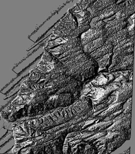 LIDAR-based,
full-feature hillshade view of the town of Lilliwaup, Wash. (Mason County),
in the western Seattle area. The Puget Sound LIDAR Consortium makes such
highly detailed images available on the Web in a variety of formats.
LIDAR-based,
full-feature hillshade view of the town of Lilliwaup, Wash. (Mason County),
in the western Seattle area. The Puget Sound LIDAR Consortium makes such
highly detailed images available on the Web in a variety of formats.