
|
 |
|
Internet
Mapping Helps Local Communities Introduction The NAUTILUS Project was begun at the University of Connecticut in 1999. NAUTILUS, which stands for Northeast Applications of Usable Technology In Land planning for Urban Sprawl, is one of nine Regional Earth Science Applications Centers (RESAC) funded by NASA to develop programs and applications that use remotely sensed data. The project’s mission is to make the power of remote sensing technology available, accessible and practical to land-use planners and decision makers who are concerned about the impact of urban sprawl and other natural resource issues within their communities.
Geospatial technologies provide communities with extremely valuable tools to evaluate and manage natural and cultural resources, to assess the impact of proposed development, to manage water supplies, to prepare emergency disaster plans, and to perform numerous other tasks that involve the use of spatial data. Unfortunately, contributions from such technologies often go unrealized because communities lack the resources, the finances, or the staff to acquire and use these elements effectively. Fortunately, recently developed Internet technologies are making it possible to create and deploy relatively low-cost online mapping applications that can be used by communities to replace the more expensive, complex geographic information and image-processing systems. The NAUTILUS Project has developed several prototype Internet mapping applications that include educational materials to help new users learn their way around the online resources. These applications give community officials, planners and the public at large full access to cutting-edge research results and NAUTILUS data products, including temporal and spatial patterns of land-use changes, depictions of forest fragmentation, impervious cover mapping, and other key natural resource information. With ER Mapper IWS (Image Web Server) and ESRI’s ArcIMS (Internet Map Server) Web mapping technology, remote sensing images and GIS data can be viewed quickly by using a simple Internet browser. Raster images and vector layers can be easily integrated to show, for example, the temporal and spatial pattern of land-use and land-cover changes. Users can do more than simply view static maps; they can interactively browse, explore, query and perform basic GIS analyses. NAUTILUS also provides important educational tools and materials that help users understand these technologies, as well as explanations on how various data layers can be integrated with land-use decision making. Internet GIS Mapping Software There are many software packages on the market for serving remote sensing and GIS data; each has its own strengths and weaknesses. Several factors led NAUTILUS researchers to select ER Mapper IWS for serving up raster images. A large volume of remote sensing data, such as high-resolution IKONOS imagery, was needed online to show the temporal changes and spatial patterns of land-surface information across varying geographical areas. Image files can be very large in size, depending upon the geographic extent covered, the spatial resolution, and the radiometric resolution. Internet connections are often slow in handling and serving large image files. ER Mapper ECW (Enhanced Compressed Wavelet) format compresses images to a more manageable file size (ratio of compression to original – 1:5, 1:10, 1:20, etc.) without a significant loss of image quality. This circumstance leads to the second reason why ER Mapper IWS was chosen – image quality. Technology that enables the delivery of highly compressed images without a significant loss of image quality is highly desirable. ER Mapper ECW format gives the user the flexibility to set the file size and the quality level based upon one’s desired application. ER Mapper’s data storage and delivery format enables the handling of different geospatial data types, coordinate systems and projections, thus facilitating integration with other GIS data layers. ER Mapper IWS is supported by different Internet browsers including Internet Explorer and Netscape and performs at an acceptable speed, even with dial-up connections. It can show both individual images and "geolinked" images and, because these images are geo-referenced, two or more images can be displayed together seamlessly. It also allows for quick zooming, panning and image transparency functions. Finally, ER Mapper IWS allows the integration of ArcIMS data layers, mainly vector layers, with the raster imagery. Several reasons led NAUTILUS researchers to use ESRI’s ArcIMS to serve up vector GIS layers. First, ArcIMS has the basic functionality of a true GIS. It can display many vector GIS data layers in addition to imagery such as orthophotographs and geo-referenced hillshade and relief images. Second, its quick viewing ability and analytical functions and tools offer true interaction with the data. For example, before a hearing on a project, a local wetlands commissioner can access the NAUTILUS ArcIMS site from home or from the local library, zoom in on the project site, select a nearby wetlands feature, and create a buffer from the boundary to assess setback requirements for the project. Third, ESRI provides ArcExplorer, which is a free GIS viewer that allows the user to connect to ArcIMS project files and data on a remote server, bringing them directly into a map display. This function allows the user to integrate his or her data with other data that would otherwise not be available for analysis. ArcIMS is supported by both Internet Explorer and Netscape, works at relatively low bandwidths, and operates with customizable interfaces. With the Internet mapping applications developed by NAUTILUS, local planners can use GIS applications and do analyses even with limited budgets, minimal or nonexistent GIS staff, and without expensive GIS software. Although the capabilities of Internet mapping are still limited as compared to fully functional software packages, Internet mapping makes remote sensing and GIS technology more accessible to the general public. NAUTILUS found ArcIMS and ER Mapper IWS to be sufficiently integrated to allow users to view raster images and GIS layers together as either reference or background. Furthermore, viewing GIS and raster images captured at different dates allows planners and the public to objectively view landscape changes and urban growth in any area or region. This information, in conjunction with economic data, can help determine what types of growth are advantageous and disadvantageous for a town, and also aid in shaping future policy decisions. GIS and Remote Sensing Data Served Utilizing both types of Internet-based mapping products gives NAUTILUS the flexibility to serve almost any type of raster and vector information. NAUTILUS has made available raster imagery that includes multi-date Landsat, SPOT, digital orthophotographs, IKONOS four-meter true- and false-color imagery, IKONOS one-meter panchromatic imagery, digital raster graphic files, and georeferenced terrain images. Examples of vector-GIS data include aquifer protection zone, soils, wetlands, open-space land, biodiversity studies, greenway plans, natural diversity database, percentage of imperviousness by watershed, three decades of land-use changes, public wells, and many more. While the majority of the data served are generally available to the public, the data oftentimes do not get to the people who need it because they either do not know who or what agency holds the data, or they have trouble understanding how to use them. NAUTILUS has also created a detailed data catalog about each GIS layer and remotely sensed image on this Web site to provide users with additional information. Educational Materials Many local land-use planners are volunteers with limited access to geospatial data, and with limited time to develop relevant uses for the data. Simply providing data or maps is not enough. Land-use decision makers need both improved remote sensing-derived information and meaningful access to this information. NAUTILUS not only provides remote sensing and GIS data online, but also has developed a series of educational tools and tutorials to help land-use officials understand how to use this technology. Educational tools and tutorials can be found under the outreach section on the NAUTILUS Web site. "Viewing Images and Maps on Your Desktop" is a simple tutorial that describes how to view ArcIMS map layers and ER Mapper IWS images, and how to integrate them for geospatial analysis. The "Image Viewing Key" is designed to assist users in recognizing land-cover types in remote sensing images with different band combinations and seasons. "Comparison of Remote Sensing Images" is designed to improve the understanding of the relationship between images of varying spatial resolution. "Connecticut Town Check-up Tool" shows general geo-facts for each town with just one click. These educational materials and tutorials are designed for professionals who want to learn about geospatial technology and mapping applications in an online environment. Advantages and Disadvantages There are many advantages to Internet mapping. First, most Internet users have no problem accessing the GIS data and do not need extra assistance or support. Second, local land-use officials and the general public are able to make decisions based on the latest GIS and remote sensing data and products developed or derived by technical specialists. Third, Internet mapping opens up new opportunities such as the integration of other online information or existing data for mapping and analysis. Also, with advanced Internet mapping applications, a user can interactively query the data of interest in order to derive the most useful information. Finally, Internet mapping applications allow end-users to access digital mapping and remote sensing data without having to purchase and learn specialized software. Internet mapping applications also have their disadvantages. For one, they do not provide the full functionality of desktop GIS software. Second, Internet mapping may not provide the specifics needed for large-scale projects and analyses. Also, the use of Internet mapping applications is dependent upon network traffic volume and the number of users at any given moment. If either is large, response times can become so slow as to cause users to give up and seek alternative sources of information. Conclusions Internet mapping applications are extremely valuable technologies capable of providing diverse datasets and integration capabilities to non-technical users of spatial data. NAUTILUS explored and developed prototype applications with ER Mapper IWS and ESRI’s ArcIMS programs; however, there are other Internet mapping programs that can be considered when evaluating the usefulness of Internet mapping. Educational tools and tutorials are essential to show how best to use these technologies and help local officials and the public understand GIS and remote sensing technologies. With Internet mapping, it is a simple task for local officials and the public to access GIS and remote sensing image data and products that will empower them to better manage their town’s future.u
About the Authors: Yongjun Lei, formerly with the NAUTILUS RESAC at the University of Connecticut, is a systems analyst for the city of Virginia Beach, Va. Emily Wilson is a research assistant with NAUTILUS. Jeff Bolton, also formerly with NAUTILUS, is an environmental analyst at the Connecticut Department of Public Works. Daniel Civco is an associate professor of natural resources management and engineering at the University of Connecticut. He is also the director at the Center for Land Use Education And Research. Sandy Prisloe is a geospatial IT specialist for the state of Connecticut.
|
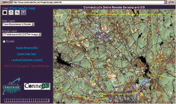 Figure
1. An example of ER Mapper IWS serving image and vector layers online
on the NAUTILUS web site.
Figure
1. An example of ER Mapper IWS serving image and vector layers online
on the NAUTILUS web site.