| GIS and Aerial Imagery Accessible Throughout the Organization
By Dave Davis Much has been documented lately about the ability to use high-resolution aerial imagery within GIS applications and provide access to that data throughout an organization. Recently, development of the industry seems to have centered on how organizations can expand the use of GIS data and imagery for use over the Internet. This is a big step for GIS, and the industry has seen a lot of growth in this area. 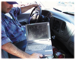 Out in the field using Field View. The high-resolution imagery helps to determine interferences with utility lines, trees, working at night, or in the snow. Out in the field using Field View. The high-resolution imagery helps to determine interferences with utility lines, trees, working at night, or in the snow.
The most recent achievement is now the ability to extend the same GIS data and imagery "to the field" for onsite GIS work. No doubt, these improvements came about through new developments in hardware and data storage, plus improvements in the ability of computing software to support a move into the field with laptops and other mobile computing devices. Currently, a majority of GIS data can benefit outside work all the way to high-resolution aerial imagery, which has traditionally been restricted to high-end workstations due to their extremely large image file sizes.
The city of Madison, Wis., has incorporated advanced software tools from both Intergraph and LizardTech to expand high-resolution aerial imagery throughout multiple departments. Serving a growing population of more than 200,000, the city has used GIS technologies within the CAD, planning, utilities, and engineering departments for the past 10 years. Many disparate hardware and software platforms exist throughout their various departments, with the primary GIS software supplied by Intergraph Corp. Building a Useable Aerial Image Mosaic
The city of Madison originally received a series of aerial photographs comprised of both one-meter-resolution (countywide) and six-inch-resolution (citywide) imagery tiles. Given the extent of the area (up to 158 individual TIFF tiles), the city found it very difficult to manage and work with this large number of files. In its search for a solution, the city discovered LizardTech's MrSID at a conference and, after a sample encoding, decided to purchase it to complete its aerial image set.
The city of Madison used MrSID to reduce file sizes and keep the visual and geometric qualities of the aerials intact. Then they produced individual MrSID image tiles in six-inch resolution, and a complete mosaic of the city in one-foot resolution. Also, overviews were extracted from Intergraph's COT raster format into TIFF, and then converted to MrSID format. The images were encoded into MrSID format at a 20:1 ratio, thus reducing the file size from over 30GB down to 1.5GB with no discernable loss of image quality. This allowed the city of Madison to have its complete image mosaic stored on two CDs instead of on more than 30. It also provided the ability to increase the amount of users from 40 to nearly everyone in the organization.
Additionally, since more people were able to gain speedy access to the imagery on their own machines, requests for plots from outside departments were reduced. MrSID viewers were spread throughout numerous departments, including engineering, police, emergency, sewer (wastewater), and the parks system. The city now is also able to sell this image set to real estate agents, developers, and the general public on a cost-recovery basis, thus providing a much improved return for the city's initial investment in high-resolution imagery. Intergraph's Web Map Delivers GIS Data over the Internet
In addition to its internal use, the Madison Mapping and Records department (MADMAPS) has developed an online maps and database web application using GeoMedia Web Map software. The MADMAPS site went live in February 1999, comprised of multiple GIS data layers including the city's official maps, assessor's parcel maps, fire department run maps, police sector maps, storm sewer records, sanitary sewer records, and street names and addresses. A complete set of aerial imagery mosaics in NAD 27 and Dane County projection coordinates are also available in COT format. In the near future, when the city will acquire new aerial imagery at six-inch resolution, this imagery will also be encoded into MrSID format and tested for use with the online GeoMedia Web Map system to replace the COT aerials. Integrating Imagery into Field View
While MrSID made high-resolution aerial imagery available throughout multiple departments, it was highly desirable to expand MrSID to the 100-plus Field View stations in the city's large field workforce. Field View is Intergraph's low-cost map-book replacement that takes Intergraph MGE, FRAMME and other geospatial data out into the field for remote mapping applications. The city worked closely with Intergraph specialists in Huntsville, Ala., to make MrSID imagery available on the Field View 3.1 platform. Benefits for Multiple Departments
The city's external workforce can now gain access to the MrSID image set directly inside Field View, and provide immediate results for onsite work with the existing Intergraph vector data. For utilities work, a visual reference accompanies the vector GIS data. The MrSID imagery helps to determine interferences with utility lines and trees, and in working at night or under inclement weather conditions. Given the hazardous winter weather environment, having MrSID aerials available to Madison's external workforce has become an important tool for them.
There are now more than 100 Field View users, and most of the city's departments have full access to the MrSID image set. For example, the fire department is using MrSID imagery in Field View to locate fire hydrants that are buried under snow, or to quickly identify hydrants that give the highest water pressure in an emergency response situation. Conclusion
Due to the increased capabilities of hardware and software tools, the city of Madison, Wis., can now fully reap the benefits of high-resolution imagery. Just a few years ago, most city departments would not have incorporated GIS and high-resolution imagery into their workflow. Now they can do so with relative ease, obtaining the full benefits that, in the past, were restricted only to a few GIS departments. About the Author:
Dave Davis, RLS is with the City of Madison Engineering Division and can be reached at: [email protected] Back |

