| Remote Sensing Applications: Demystifying the Myth - Part 1
By Skip Maselli Thoughts about remote sensing services and imagery providers sometimes conjure up the image of a man with a pencil-thin mustache wearing a pinstriped suit, selling snake oil or hair tonic on stage at a state fair, complete with a dancing bear. I can hear the "ka-ching ka-ching" as the dollar wheel spins out of control. Remote sensing is not hair tonic - it needs to be manipulated in order to have any value, not simply "poured over the landscape." Remote sensing can be an affordable and extremely useful asset to a GIS-related project. This article will help provide some insights into the technology, applications, and background to take some of the mystery out of using remote sensing for one's own GIS project. 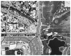 Figure 2. Panchromatic imagery Figure 2. Panchromatic imagery
Remote sensing is the science of obtaining information about an object, area, or phenomenon through the analysis of data acquired by a device not in contact with the "particular" under investigation. In the GIS field, it is represented through satellite- and aerial-imagery acquisition, and the products that come with it.
Remote sensing is rarely the end-all and be-all; it is often but one step in a much larger process. The emphasis on its use begins with a clear definition of the problem and the elements necessary to solve that problem. For example, right-of-way planning, corridor mapping, and hydrologic or environmental monitoring projects often require the identification and quantification of land cover, among other details. Land-cover information can often be obtained from vector-based GIS datasets that are held by local and regional agencies, federal datasets such as TIGER, or rasterized maps like the USGS Digital Raster Graphics (DRG). These and other remote sensing-derived products may not provide the scale, pixel resolution, or currency that is required. Furthermore, land use and land cover change frequently and require routine updates. Standardized products can become outdated quickly, even as remote sensing imagery continues to improve in both quality and temporal accuracy.
The decision to use remote sensing data should be driven by clearly defined requirements, and regulated by resources available to the project. These resources include human resources, software, hardware, and the ability to employ them. Other criteria for using a remote sensing application can include the sequencing and timelines of the land cover project. If a project's remote sensing component doubles the cost, it may not be the wisest choice. On the other hand, various uses of the data can allow more than one department within an organization to share these costs and thus reap multiple benefits. Carefully Identified Problem
To illustrate a problem, we begin by considering the construction of a right-of-way, and the impact it may have on the environment. (Figure 1) The determination of the best possible route and its environmental impact requires a thorough understanding and quantification of the land cover within that right-of-way (ROW). The problem is that there is no up-to-date or complete data source that shows this area of land cover with respect to spatial and categorical accuracy. The ROW buffer polygon(s) must be overlaid onto a land-cover map of the appropriate scale to calculate the spatial extent and location of each affected land class. The land-cover map must show distinctions among water bodies, grass types, tree species, roads and parking lots, bare-soil types, and other impervious surfaces. Because 12-square-foot colonies of vegetation are the minimum size, four-meter color digital satellite imagery with a near- or mid-IR band would be the optimal choice. The images will need to be sorted into various land-cover categories, converted to a vector GIS layer, and then intersected with the ROW buffer polygons.
By the time this project is complete, the original satellite imagery will not even be visible to the end-user of that information. The result is polygon vector coverage and a set of tables that describes the tracts of land affected by the construction. While this imagery is essential to solving the problem, it is not the product itself. The Imagery
The most important requirement for a remote sensing application is, of course, the imagery. Both photographic and digital imaging systems can acquire panchromatic or multi-spectral imagery.
Remote sensing technology is rapidly progressing as an industry. Film and digital recording devices are being used aboard both airplanes and satellites. The federal government is easing satellite resolution restrictions. Aerial survey firms are beginning to fly advanced digital cameras to compete with satellite imagery providers. Airborne and space-borne imaging systems each provide their own sets of benefits. This can be confusing when selecting the best system for a particular application. We'll try to shed some light, so to speak, on the subject in order to clarify the use of imagery within one's GIS. Multi-spectral imagery (MSI) is a record of multiple wavelengths of light. Most often, MSI implies the measurement of infrared energy reflected from the ground, along with the visible bands of blue, green and red.
Multi-spectral imagery (especially digital) is best for land-cover classification because it takes advantage of how different wavelengths of light react uniquely to land-cover types. These unique reactions provide the ability to distinguish the subtlest differences (spectral signatures) in land cover. The diversity of colors necessary to visually interpret terrain and cultural features practically demands that multi-spectral imagery be used for many land-cover classification applications. Below, we present a brief comparison between film and digital MSI remote sensing systems.
Color infrared film produces a single color image by exposing three emulsion layers. Film images are recorded in continuous tones by exposing microscopic silver halide grains to light. One emulsion layer is often sensitive to reflected infrared light and records it with various shades of cyan dye. The green- and red-sensitive layers of the film respond to their appropriate wavelengths of light. These layers record green and red "energy" with yellow and magenta dyes, respectively. It should be noted that all three layers also respond to blue energy, although most of that gets filtered out. The cyan, yellow, and magenta layers are combined to produce the photographic image. This is usually a false-color IR image (red=IR, green=red light, blue=green light); just such an example is illustrated in Figure 3. Film resolution is sometimes measured in line pairs, and is much finer than in digital systems. Resolution is the minimum distance between two objects in an image that still allows them to be viewed as separate and distinct. It is not the smallest object visible in an image. This is because some objects that are smaller than the pixel size are bright enough to dominate the entire field of view.
Multi-spectral "digital" imagery records separate raster layers representing discrete wavelength bands. Each layer is a matrix of colors or shades formed by exposing chemically coated detectors to light. As the digital sensor scans the Earth, detectors record rows and columns of picture elements (pixels) within a file. (Figure 4) Chemical coatings on the detectors react differently to different levels of light with specific bandwidths. The bandwidths constitute the spectral resolution of the system. The coated-charge coupled device (CCD) array converts incident light into electronic signals. Each pixel receives a brightness value based upon the photoelectric effect of the light on the detector that reflects from an area on the ground. (Figure 5) Through an analog-to-digital conversion process, each electronic charge is converted to a binary number for each pixel in the matrix. And each pixel has a discrete x/y location on the Earth. For example, Space Imaging's IKONOS data can be acquired as 11-bit pixels, essentially 2048 shades of gray (brightness values). Most systems and image-processing software support eight-bit digital imagery (256 brightness values).
Each layer can be examined separately as a gray-scale representation, where the brightness is indicative of the amount of that particular wavelength reflected or emitted by an object on the ground. The bandwidth and sensitivity of each layer can be as discrete to record red, green, and blue light individually (MSI), or wide enough to cover blue, green, red, and IR in a single gray-scale image (panchromatic). Multiple gray-scale layers can be viewed simultaneously by illuminating each with one of the primary colors; when combined, these images produce a color image. Every eight-bit pixel in each layer has 256 possible values; it therefore represents a single combination (or 'signature') out of 16 million possible pixel combinations - 256 x 256 x 256. The signature is unique for each object and has the ability to distinguish colors among various land-cover objects that may otherwise appear identical to the human eye. (Figure 6)
Each pixel samples a generalized area on the ground within a field of view. (Figure 7) Consequently, digital imagery resolution is based on the pixel. For example, Landsat has 30-meter pixel resolution, while Space Imaging IKONOS has a one-meter pixel. An object surveyed to most precise geographic coordinates could still have an error equal to the pixel size. While this comparison may be unfair, film has a much finer "grain" or, effectively, a much narrower field of view than do digital imaging systems. (Figure 8) Film generally provides the best resolution of the smallest objects. Bright objects that are smaller than the nominal pixel size may be so bright that they actually appear larger in the image. Of course, flying height plays a major role in resolution results from either system. Photography is often scanned to form a digital image. Once scanned, the photographic resolution is altered and takes on the resolution of the scanning system. While it can be reduced, scanning a photograph -no matter how small the pixel - will not improve its true resolution.
As a side note, subpixel analysis technology attempts to deconvolve the spectral signature of a pixel into its constituent spectral components. These components have been shown to represent multiple objects within the pixel. ERDAS IMAGINE and RSI's ENVI have demonstrated this facility in their software.
Be aware that increasing spatial resolution can dramatically increase image-file size. Furthermore, improving resolution after acquisition through image processing may be somewhat misleading. If a four-by-four-meter single-pixel sample is taken from the ground, increasing its resolution by "chopping" it into finer pixels does not tell you anything more about that area on the ground. (Figure 9) Acquiring the Imagery
Many cities and counties maintain remote sensing contracts for aerial photography and survey services. Imagery is often acquired on a three- or five-year basis. Most involves high-resolution (six-inch to one-foot) large-scale photography. Geometric parameters used in the acquisition are of particular interest in order to support ortho-rectification procedures. Geometric parameters include sidelap, overlap, camera orientation, flight altitude, geographic position, topography, Earth curvature, and other considerations such as ground-control measurements. Due to the lifting of restrictions in resolution, the commercial satellite imaging industry is beginning to better address the rigorous mapping requirements of many agencies. In this regard, satellite and airborne imaging systems compete as well as they work together. While not exhaustive and without exception, a set of comparisons is provided as noted in Table 1.
Aerial photography is carefully acquired at specific altitudes and scanned at the appropriate resolution. Both airborne and satellite platforms support framing, sweeping, and push-broom systems. (Figure 10) Digital frame cameras "snap" the entire raster array in a single shot. Sweeping systems acquire the imagery through rotating or swinging mirrors that reflect the light with each pass onto a CCD. The image is formed one pixel at a time. Forward-motion compensation must be employed for geometric integrity. Push-broom systems have fewer moving parts, rely mostly on the forward motion of the satellite, and acquire entire rows simultaneously. The acquisition of multiple bands at the same time adds to the challenge of maintaining precise geo-registration between different bands.
In remote sensing data acquisition, timing is of the essence. If one is planning a cadastral mapping project, street centerline adjustment, or impervious mapping, acquisition is best scheduled during the time when leaves are off the trees. For most regions, wintertime is when trees are bare, making the ground more visible even from off-center aircraft viewing angles. Day-of-week and time-of-day factors may also be important; weekends are good because there may be fewer cars on the road, which can be distracting when performing mapping - especially in stereo. The angle of the sun is important if shade is one of the interpretive cues to be used in the remote sensing application. Cloud cover is less of a concern for airborne systems than it is for satellite systems. But be aware, cloud-free imagery on specific dates may prove costly. Be sure to ask the imaging company about cloud-cover options and don't plan acquisitions during monsoon season.
General land-cover and vegetation mapping obviously fares better during lush growing periods. Wavelength and spatial resolution should be planned accordingly. There are many resources online that discuss wavelength combinations for vegetation discrimination and identification. If one is mapping vegetation colonies or general land cover with mapping units no smaller than 10 x 10 meters, the airplane (or satellite) may be able to fly higher to capture more ground with fewer flight lines. This translates into fewer dollars spent but a risk of greater cloud cover. Note: Part II of this article will be found in next month's issue. About the Author:
Skip Maselli is western director of regional operations for InfoTech Enterprises Inc., Tucson, Ariz. He may be reached via e-mail at [email protected]. Back |

