
|
 |
|
Security
At Its Best While many catastrophes have left their mark on our country, none may compare to the impact that the September 11 terrorist attacks have made on our lives-both personally and professionally. In ways both large and small, we are constantly reminded that safety and security are feelings we can no longer take for granted here in the United States. However, Americans are unwilling to reside in fortified bunkers and give up the freedom that makes living in this country such a privilege. We still want our children to play safely in our back yards, our offices to have windows rather than steel bars, and our stadiums to host our favorite sports teams on the weekends. To ensure that these hallmarks of American life remain, homeland security efforts have significantly increased to better protect our homes, our businesses and our places of recreation.
In this post-September 11 world, Americans take extra precautions to protect both themselves and their day-to-day business operations against terrorism. In an exclusive survey conducted by SECURITY Magazine, nine out of 10 companies have re-evaluated their overall security operations, upgraded or purchased new security systems, increased the size of their security staffs, or begun new security programs. In fact, 85 percent of businesses believe that, throughout 2002, the tragic events of September 11 will continue to influence their security operations as well as their business models. Geographic Information Systems (GIS) services are poised to play a significant role in addressing the security concerns of businesses and local, state and federal government agencies across the country. Currently, GIS can provide decision-makers with the data they need to confidently confront a wide variety of threats that include natural disasters, terrorist attacks, sabotage, and other types of crises. Furthering the capabilities of traditional disaster relief, GIS provides applications such as managing and locating resources, planning, and visual decision support. GIS technologies assist in eliminating unauthorized access to client data, controlling the electronic transfer of secure data, providing protection from hackers, and managing access rights for remotely located employees. While restricting data access to address security concerns, GIS technology is able to provide valuable data to employees, customers, partners and suppliers. Additionally, GIS technology protects data and eliminates unplanned outages, unauthorized access, and unauthorized program execution. Overall, GIS technology offers companies data-sharing abilities, fast response, speedy real-time access to information, strong analytical capabilities, and powerful visualization. A Dramatic Example of GIS in Action GIS capabilities related to homeland security are hard to imagine without practical examples. The National Consortia on Remote Sensing in Transportation provides an excellent illustration of GIS in action. Think about a terrorist invasion of one of our nation’s nuclear power plants. One measure the government might try to implement would be a large-scale evacuation of every person within a 20-mile radius of the plant. A successful evacuation of this size would require extensive advanced planning and GIS coordination, including the use of GIS to identify safe exit routes as well as the amount of time needed to evacuate the area. With remote sensing data, road detection algorithms, and an accurate map of the highway network, a GIS-based program could develop the most effective evacuation method. The Crime Stopper In an ideal world, the best preventative is to stop a terrorist act before it occurs, not only overt acts but also insidious infiltrations into government and corporate computer systems, and utility power grids. The GIS industry can readily create specific procedures within detailed corporate and government security plans for the protection of data, facility access, and information systems security. In fact, it is recommended that all GIS companies implement an overall security management program (similar to TQM or ISO-9000) to ensure that training requirements are met, procedures are documented and implemented, and all transactions with data are recorded for review and verification. Beyond an overall security plan, arrangements should be made for individual GIS projects. Of course, every project will need a different set of requirements, which means companies must develop separate project plans for each specific project. As tempting as it might be to cut costs by cutting security corners, we must be ever diligent in creating, implementing and maintaining those security systems so as to protect our clients and the public at large. If you are a GIS customer, you should include in your project plan a thorough discussion of your security needs with your GIS provider. While every security plan is unique, there are a few steps common to all GIS security plans. As ESRI’s ArcNews reported, these five steps should be part of an overall plan to prepare for any kind of emergency or disaster:
Types of Projects While it is easy to see how government agencies would require GIS security planning, corporate America may not see the need for these services as clearly. However, because the United States is a country that relies upon the success of its corporate infrastructure, companies must realize how important their security is to overall homeland security efforts. For example, below are listed three areas that, if infiltrated by terrorists, could quickly cripple the U.S. economy and its infrastructure.
The unique capabilities of the GIS industry can help all these industries plan for and execute stringent security measures and backup procedures to minimize the risk of these awful scenarios actually happening. For example, what if there was an anthrax scare at your data integration facility? Naturally, the facility would be evacuated as soon as the possible biohazard was found, and HAZMAT teams would swarm in to test and clean the facility. During this lengthy process, what would happen to your data? At best it would just sit there, accomplishing nothing. At worst it would be infiltrated by a hacker, manipulated, copied and used inappropriately, hurting your company and possibly damaging national security. However, if your GIS provider develops and implements a security plan before taking on your project, the entire incident can be avoided. With stringent security controls in place for gaining access to the facility where your data is integrated, the anthrax scare may never happen. If an alarm is sounded and the facility evacuated, one push of a button can securely transport your data to a backup facility. If an infiltrator poses as a HAZMAT worker and tries to hack into your system, he or she will be locked out by the stringent security that guards your data. And if the terrorists know the remote location where your data is transferred, remote access controls can shut them out from the secondary facility. Future Growth The GIS community faces a sobering and unique opportunity. Our industry has worked diligently to showcase the power and capability of GIS, including its distinctive characteristics in disaster preparedness and crime management. It is comforting to know that our efforts are now being put to their best possible use–the safety and security of our country. Government agencies and businesses that can benefit from these specialized security capabilities need not wait for them to be invented. The GIS industry stands ready to provide handheld devices, GPS systems, and many other tools that will be needed to help win the battle against terrorism. Just as our military now has guided missiles, strategic weapons and computers on the battlefield to go after terrorists in foreign lands, we have many of the same kinds of GIS-based tools to keep us safe in our own back yards. About the Author: |
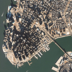 To mark
the six-month anniversary of the Sept. 11 attack on the World Trade Center,
Space Imaging is releasing this Jan. 22, 2002, satellite image showing
a macro view of the immense cleanup effort. The image provides content
and helps put the story into a context that may be useful in reporting
on this important anniversary. Credit:
To mark
the six-month anniversary of the Sept. 11 attack on the World Trade Center,
Space Imaging is releasing this Jan. 22, 2002, satellite image showing
a macro view of the immense cleanup effort. The image provides content
and helps put the story into a context that may be useful in reporting
on this important anniversary. Credit: