| Radar Revolution: Revealing the Bald Earth
By Diane Coleman In the past, the mapping community had viewed radar technology with great suspicion as either too high-tech, too complicated, too different to be understood, or much too expensive. What is worse, the maps it produced couldn't readily be used, because we didn't understand them.
Today, radar mapping - both airborne and spaceborne - has proven its utility beyond any doubt. This technology has been both acknowledged and accepted as a critical mapping and monitoring tool by powerful geospatial information users that include the telecommunications industry, oil and gas exploration companies, mapping and disaster management agencies of the federal government, pipeline companies, and environmental agencies. One reason that radar is so broadly accepted as a mapping tool is its newly developed automated capability of creating accurate bare earth digital terrain models (DTMs) from airborne interferometric radar. 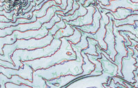 USGS contour comparison map segment: Selected area from 1:24,000-scale USGS quad, showing comparison of contours from LIDAR, radar bare Earth DTM, and USGS map. Green lines are USGS contours (40-foot interval); blue and orange lines are LIDAR contours (unsmoothed and smoothed respectively); red lines are radar bare Earth contours. Photo courtesy of John List, USGS. USGS contour comparison map segment: Selected area from 1:24,000-scale USGS quad, showing comparison of contours from LIDAR, radar bare Earth DTM, and USGS map. Green lines are USGS contours (40-foot interval); blue and orange lines are LIDAR contours (unsmoothed and smoothed respectively); red lines are radar bare Earth contours. Photo courtesy of John List, USGS.
Twenty Years of Radar "On the Edge"
For more than 20 years, Intermap Technologies Corp. - and its predecessor company Intera Technologies - has led the world in the development of airborne radar technology for mapping. The company has successfully brought the unique capabilities of airborne radar to such widely diverse uses as sea-ice mapping and monitoring, geological exploration, tropical forest and land-use mapping, and flood and floodplain mapping. In every case, this innovative firm has had to develop the tools and teach new users to understand and appreciate the value of their technology.
In 1996, when the company dropped its older, synthetic aperture radar in favor of an interferometric radar "STAR-3i" system mounted in a Learjet, Intermap achieved the ability to produce highly accurate digital elevation models (DEMs) and image data over very large geographic areas. In the five short years since that date, Intermap has made impressive gains in the overall mapping market. STAR-3i data and products have been tested by critical government agencies that include the National Imagery and Mapping Agency (NIMA), the U.S. Geological Survey, NASA's Stennis Space Center, the U.S. Army Corps of Engineers Topographic Engineering Center, and the Institute of Navigation. Private users, including Willis Consulting (U.K.), have also found the company to be a cost-effective source of mapping data. However, corporate president Brian Bullock explained, "While the quality of the radar image maps and the DEMs was exceptionally high, one thing stood in the way of full acceptance by the mapping community - the ability to produce bare earth DTMs." DSMs, DEMs and DTMs: Bare Earth is a Good Thing
Most remote sensing systems, including aerial photography, LIDAR and radar systems that are used to generate digital elevation models, collect data from the first surface with which they interact. The resulting DEMs are representative of the elevation of that surface (i.e., the surface or height of crops, trees, buildings, bare soil, roads, towers, etc.), and are thus termed DSMs (Digital Surface Models). While this first-surface information can be useful for applications such as view-shed analysis, flight simulation or communications tower siting, it does not provide elevation data required by most users to detect the true bare earth surface.
Bare earth elevation data represent the true terrain surface and are critical for most uses of DEMs. Mapping of flood plains and flood-prone areas, pipeline corridor planning, canal or highway engineering, and basic topographic mapping all require elevation data for the terrain surface itself, to varying levels of accuracy. These are Digital Terrain Models (DTMs). DTMs from Remote Sensing Systems
Traditionally, DTMs have been prepared by using stereo aerial photography. To derive bare earth DTMs from aerial photography, the DSMs created first are adjusted by using a combination of manual and automatic techniques that look between surface objects such as trees or buildings all the way to the ground, where possible. Topographic contours created from the DTMs are fairly representative of the terrain surface, not the forest canopy nor the building heights in an urban area. To date, these contours have been the standard source of information for detailed topographic analyses.
Two other airborne systems, LIDAR and interferometric radar, are successfully challenging this primacy. LIDAR systems have recently gained attention for their ability to provide highly accurate ground elevation data using rapid laser light pulses along transects within the area of interest. Typically flown at a low altitude, the resulting footprint is small and pulses can "see" the ground through openings in the vegetation or in built-up objects. These systems are often used to produce highly accurate DTMs over relatively small areas, as their cost tends to be high.
Radar is recognized as a remote sensing technology that provides wide-area coverage with day/night, cloud-penetration advantages over optical sensors. As such, it has been historically in demand for mapping and monitoring in cloud-prone and/or "dark" regions such as the tropics and the polar areas. More recently, there has been growing interest in its cost-efficient, wide-area mapping capabilities in temperate regions as well.
Intermap first derived DEMs from stereo airborne radar some 15 years ago, using photogrammetric principles adapted for stereo radar (radargrammetry) in their Starmap process. Both the DEMs from stereo radar, and the interferometric radar DEMs that followed after 1996, were inherently first-surface representations. This process works exceedingly well in areas devoid of surface objects. But in areas covered by vegetation, the X-band radar signal is scattered within the vegetation, and the elevation measurement that results is actually located at some depth within the foliage. Thus it is neither fully representational of the height of the vegetation nor of the bare earth, making the elevations doubly difficult to use. In urban areas, elevation data were even more distorted; complicated patterns of different roof types, interspersed trees and "street furniture" produced complex scattering and hard-to-interpret elevation data. It was possible to remove many of these surface objects, but this is always a lengthy, and thus costly, manual process.
Now, however, Intermap has made a breakthrough in the automatic derivation of terrain elevation data from its STAR-3i system. Radar Gets Down to the Ground
Over the past two years, Intermap's Research Group has worked with researchers at the University of Calgary (Alberta) on a bare earth DTM solution for their STAR-3i elevation data. Intermap's chief scientist, Dr. Bryan Mercer, explained the challenge this way. "Our dual objective was to successfully remove objects from the terrain surface while preserving the detail in the terrain itself, and to do it all in an automated manner."
Together they developed a novel, hierarchical surface-fitting approach called TerrainFit which, in fact, is generic enough to be applied to DTM generation from other sensor-derived data. The method uses an "image pyramid" of DSM data - a series of images with different resolutions - generated from the original image. At the bottom of this pyramid is the input DSM data, containing many points which are not true terrain points. In other words, these points are at the tops of buildings or trees or other objects on the Earth's surface. Using the minimum value in a defined window in the lower image, rather than the average value as is usually done in image resampling, the next-higher-level image is created, gradually removing buildings, trees and noisy data. At the top of the pyramid is the bare earth DTM.
Getting to this point successfully was a major step forward. However, a bare earth DTM generated in this manner is of low spatial resolution and thus not accurate enough for use in mapping. To improve accuracy, an innovative process was developed where the images at lower levels in the pyramid were used to add back the detail and accuracy of the original data, while removing objects (such as trees and buildings) on the surface.
In this process, a self-diagnostic procedure was applied, which automatically identified and corrected problem areas. For example, in an automatic object removal process, some hills and valleys may be erroneously removed along with buildings and trees. Such problem areas are identified by using something called a "difference map" that literally shows the difference between the original DSM and the new bare earth DTM. At this point, items are "added back" from the lower level image, and a new terrain surface is produced.
These results were tested against LIDAR and air-photo-generated topographic data and found to be very accurate. Vertical accuracy was better than 1.5 meters RMSE in urban and moderately mountainous regions, increasing to 2.2 meters RMSE in steep mountain regions. The program worked extremely well in urban and rural areas that ranged from flat to mountainous terrain.
One evaluation carried out by the USGS compared LIDAR contour maps, bare earth DTM-generated contours from STAR-3i, and standard USGS topographic maps of a USGS quad near Denver, Colo. The results were impressive: The radar contours were as good as the smoothed LIDAR contours, and significantly better than the USGS map contours. And because the bare earth radar process creates smooth contours in an automated manner, they can be generated at very little extra cost over the DTM production. This automation typically saves nearly 50 percent of the mapping effort required to produce topographic maps.
Very heavily forested areas remain a challenge, as they do for all remote sensing systems. These elements will be dealt with in the next phase of research. Dr. Mercer explained, "With the current approach, terrain representation is achieved by sampling the ground surface frequently enough so that the natural terrain modulation is conserved. In heavily forested areas, this is generally not possible with X-band radar, since it does not penetrate to the ground. Our approach to the next research phase will likely combine ground sampling with canopy modeling; the preliminary results are very promising." Major Topo Mapping Market Opens Up
Brian Bullock stated, "Being able to derive bare earth DTMs with an automated process was a huge step forward for our two key markets of medium-scale topographic mapping and image orthorectification."
For topographic mapping, the wide-area coverage of radar and the automated DTM-generation process means that mapping projects can be completed much more rapidly and less expensively than through standard air photo mapping. This approach provides a real alternative for budget-conscious mapping organizations. The positive results of an evaluation carried out by the USGS, one of the major mapping organizations in the world, have been instrumental in convincing the mapping community of its value.
Bullock described an exciting breakthrough in the U.S. mapping market. "Thanks to excellent results from trial applications of the automated bare earth DTM extraction", he said, "we were recently invited to make a presentation to the USGS Rapid Revision Committee. They told us that it took 55 years and $2 billion to map the United States the first time around; they are now convinced that, with this new technology, they can do the revisions in one-tenth the time and at one-tenth the cost." Intermap calculates that it could complete the 1:24,000-scale revision in as little as three years.
Marc Wride, senior accounts representative at Intermap, agreed with Bullock's assessment. "Mapping organizations everywhere are realizing that they just can't continue to collect air photos for topographic mapping, so they have started to look at LIDAR and radar as alternative data sources," he said. "With our bare earth technology today, for example, we can map half to three-quarters of the United States with STAR-3i. There is virtually no extra cost for topographic contour generation because the process is fully automated." Ian Isaacs, Intermap's production manager, pointed out additional advantages: The radar DTMs can now be horizontally and vertically integrated both with DEMs and with information layers from other data sources, giving real cost- and time efficiencies to spatial data providers and users alike. Rapid Growth in the Image Orthorectification Market
A second major market ripe for exploration is the provision of DTMs for orthorectification of satellite and airborne image data. Watching the rapid growth of the satellite image market and the need to orthorectify satellite products to enhance salability, Garth Lawrence, Intermap's vice president of marketing, described bare earth DTMs derived from interferometric radar as a tremendous opportunity. He sees a very important application in orthorectification of both air photo and satellite data, especially for clients in the image product business (such as EarthWatch, ImageSat and Space Imaging) who need DTMs that are both detailed and timely.
Gene Dial, a production engineer with Space Imaging (Thornton, Colo.), has compared stereo-generated DTMs produced from Ikonos satellite data with the bare earth radar DTMs, and found the latter to be "extremely accurate." He believes that the Ikonos satellite and airborne radar systems are complementary. "Intermap has been very good in working with us, and there are many opportunities for working together in the future, with the right match of requirements and economics," he said.
The ultimate users of such information include city and county planners, transportation planners and managers, hazards mitigation and response agencies, coastal ecosystem managers, environmental managers, and the aviation community that includes the FAA, NASA, the military, and various systems manufacturers.
One project being carried out by Intermap is for mPOWER3 Inc., a Colorado company that is one of the largest digital imaging and land information companies in the United States. Intermap is supplying precision DTMs of 4000 square miles across the county of Los Angeles. According to Hugh McKay, Intermap's international sales representative, mPOWER3 selected the radar DTM solution because their project could be completed in less than half the time required to do the work with aerial photography, and at one-tenth the cost of using any other method.
Richard Sanders is with Willis Consulting (London, England), a reinsurance brokerage firm that provides flood risk analysis and other services to the insurance industry. He was very excited about this new bare earth DTM radar development. "In 1998," he explained, "we built a model of the Thames River basin using STAR-3i DEMs and have been talking about it ever since."
For this 14,000-square-kilometer area, the use of radar DEMs for flood risk analysis provided major benefits to the company. These included, "Complete, consistent coverage of the whole area in one survey, very quickly so that conditions on the ground were similar," and at 10 percent of the cost of the main alternative, LIDAR. Sanders viewed the new, automated bare earth DTM generation as a great improvement because, as he explained, "It is absolutely essential to see the ground where the flood occurs." In the Thames study, Willis Consulting spent a great deal of time doing somewhat inconsistent manual and semi-automated post-processing removal of surface objects. With this new process, nearly all of the post-processing is finished, thereby saving them a great deal of time and money in a business that always seems to operate in a "we need this data yesterday" mode.
Other applications abound. Precision visualization is another powerful tool for community growth, navigation, and other applications. In the past, 3D visualizations that "looked pretty" were used qualitatively for fly-throughs and other simulations. With these new high-resolution, orthorectified images and DTMs, users can now make measurements and do analyses within the 3D environment. Radar: A Mapping Market Reality
Radar technology is a growing force throughout the imaging and mapping industry, providing advantages far too significant to be ignored by the market in general. Intermap's clients are thrilled with their new, automated bare earth DTM generation capability. In a world where spatial information is critical and "faster, better, cheaper" are key business watchwords, bare earth DTMs from airborne radar are rapidly invading previously impenetrable markets. Be sure to watch for the radar revolution! About the Author:
Diane Coleman is a senior consultant with Earth Observation Services in Calgary, Alberta, Canada. She may be reached by telephone at (403) 242-2103, or via e-mail at: [email protected]. Back |

