| Turkey Taps Diverse Processing Tools to Build Frequency Management Center
By Kevin P. Corbley Five years ago there were only 500,000 cellular telephones in Turkey. Today, one out of every four Turks, or roughly 16 million people, carries a wireless phone. And this number is rising quickly, perhaps too quickly for available frequencies to accommodate.
Overcrowded airwaves are not a problem unique to Turkey. This situation is repeating itself around the world. Everyone either has a cell phone or wants to acquire one. Broadcasting companies are gobbling up radio and television frequencies to launch niche-market stations. Even satellites are vying for transmission slots. 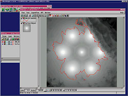 Useful signal levels and the 95 percent coverage-probability contours for the analysis of single-frequency networks of digital video broadcasts are shown in a region of relatively flat terrain. Useful signal levels and the 95 percent coverage-probability contours for the analysis of single-frequency networks of digital video broadcasts are shown in a region of relatively flat terrain.
As a result, many countries are faced with the need to more strictly enforce the regulations that govern frequency usage. Licensed wireless system operators must be monitored to ensure their networks are not straying from their assigned wavelengths, and rogue television or radio stations must be traced and dealt with.
The government of Turkey has taken an aggressive step to make sure there are enough frequencies to meet this growing demand. Its Telecommunications Regulatory Administration - formerly the Directorate of Radiocommunications - is developing a US$36 million, multi-location National Monitoring System that will perform the following functions upon completion:
• Supervise radio signals
• Measure spectrum occupancy
• Measure radio and TV broadcast transmissions
• Detect frequency infringement
• Determine and map radio coverage areas
• Analyze signal interference
• Locate illegal stations
• Gather statistics for general frequency management.
A primary element of this system is the National Frequency Management System (NFMS), which is being developed by the Communications and Spectrum Management Research Center at Bilkent University in the capital city of Ankara. This organization is responsible for creating two key software components that integrate the latest spectrum engineering, frequency propagation modeling, and geospatial data-viewing technologies to accomplish the Directorate's objectives. Regulating the Airwaves
The Directorate of Radiocommunications, which is similar to the U.S. Federal Communications Commission, awarded these contracts to the Research Center on the basis of its long-standing involvement in studying spectrum engineering for telecommunications applications, specifically in frequency planning, assignment and usage.
"We focus on anything related to the wireless transmission of information...radio, television, cell phone and satellite communications," said Dr. Hayrettin Koymen, director of the Research Center.
Initiated in 1998 and now nearing completion, the monitoring system will include a National Control Center in Ankara and seven regional monitoring facilities. There will also be two mobile broadcast measurement units and several monitoring vehicles carrying direction finding and monitoring equipment similar to that in the fixed stations.
The two most important components in the National Control Center will be its spectrum engineering support systems and its licensing database. The spectrum engineering equipment is what the Administration will use to monitor frequencies, analyze interference between stations, and pinpoint illegal broadcasts. The frequency range of the NFMS spans 30kHz to 40GHz.
The database is equally critical because it will hold all of the technical specifications and ownership information related to frequencies that have been assigned and licenses that have been awarded. Any organization that broadcasts over the airwaves in Turkey must obtain a license from the Administration to operate in a well defined frequency.
The Research Center's job is to develop the software to run these two systems and, more importantly, link them so that they can share data.
To accomplish this, the Center is relying heavily on products from three U.S. companies: spatial data processing and viewing software from MicroImages (Lincoln, Neb.), and database products from Oracle Corp. (Bethesda, Md.) and Sybase Inc. (Emeryville, Calif.) On the spatial data side of the project, Research Center staff is working with technicians from MicroImages and its dealer, HAT Geographical Information Systems & Trade Inc. of Ankara. Developing Spectrum Engineering Systems
The two software systems under development to comprise the spectrum engineering infrastructure are called monitoring support and spectrum management systems.
"The monitoring support system controls the frequency measurement functions conducted at the various stations and then visualizes the information gathered from these monitoring activities," said Dr. Ayhan Altintas, deputy director of the Research Center.
For example, software control routines will send commands from the Ankara Control Center to each remote station to measure spectrum occupancy between certain frequencies during a given time period. As this data is collected by the station, it will be sent back to the Control Center for statistical analysis and geographical display.
In cases where illegal frequency use is suspected, three stations will be programmed to monitor the same frequency with their direction-finding antennas. If all three can isolate the direction of the source of the signal in question, a simple triangulation technique can find its precise location, which will also be displayed on the map.
Display of the monitoring results on the map is managed by TNTview, a MicroImages package designed specifically to visualize and interpret digital geospatial information in virtually any kind of format. This software can combine the results of the triangulation calculation or frequency occupancy search with population distribution, infrastructure location, or transportation vectors for geographic display on the base map.
The base map upon which the visualization occurs is a raster topographic map with 100-meter accuracy. The General Command of Mapping in Turkey's Defense Ministry supplied this product. The digital map and other spatial data layers overlaid on it were processed using TNTmips image processing and GIS software.
"We chose the TNT family of software for our spatial data manipulation and viewing applications because we have to produce a lot of custom computer software in our projects," said Koymen. "TNT products have an open architecture that allows for integration of custom commands in native programming languages. The software becomes the basic user interface of the system." Managing and Modeling Spectra
The second component of the spectrum engineering infrastructure under development by the Research Center is the spectrum management system. It performs most of the calculations and modeling of frequency occupancies and signal transmissions that must be considered in assigning new frequency licenses.
"This system conducts the simulation, modeling and calculations," said Altintas. "We can calculate broadcast areas around stations, determine populations within a coverage area, and compute signal strength relative to terrain conditions."
The results will be displayed for visual analysis on a map in TNTview. Its ability to integrate data from varying sources is critical because the spectrum management system is composed of several propagation-modeling packages and custom-computation routines. These diverse packages are written in a variety of languages including C or C++, and each provides results in a different digital format.
Technicians at the Research Center have used TNTsdk, which is a software development kit provided with TNTmips that contains thousands of pre-programmed C++ language functions, many of which are related to GIS applications useful in spectrum modeling. These functions are combined and included in the spectrum management system to carry out many of its computations.
"This library of commands makes life a little easier for our programmers," said Koymen. Building a Database
The Research Center's second major task is to develop the software system that will update and manage the Directorate's main database. There are currently millions of files containing the details on every station or broadcast device in Turkey that transmits over the airwaves. Radio stations, television stations, cell site antennas, and airport security systems are all licensed and included in the database.
"There is an existing database, but much of the data is out of date or needs correction," said Altintas. "Development of the database presents an opportunity to correct the data as we progress."
The new database is being built with the ORACLE 7.0 Database Management System. Research Center technicians are using PowerBuilder, a database software tool from Sybase to customize the functions that will dramatically simplify the record keeping and query duties of the Administration staff.
The objective is to build a database that requires data to be entered only once. It will create standard forms for the Administration staff to use in issuing licenses. Once the correct information is entered, the database will automatically update itself and divert data into the multiple files where they belong.
"Database query functions are being created in PowerBuilder but are accessed through TNTview so that users can search the database by license number, frequency, or station location and have the results displayed on the map," said Koymen. "Or they can click right on the map interface to query the database."
For instance, if an Administration employee wanted to see every radio station operating at a given frequency in Turkey, TNTview would access the licensing database, find those stations, and then display their locations on the map. By pointing and clicking on a single radio station location on the map, that station's file would be accessed and its contents displayed in an on-screen text box.
"Our goal is to make all of the spectrum engineering and monitoring functions and data available through a single interface," said Koymen. Preparing for the Future
The Communications and Spectrum Management Research Center has installed both of these software systems for operational use at Administration headquarters. The software will be installed at the regional stations as they are built over the next few months.
Technology is changing so rapidly that some capabilities are being redesigned as the systems are built. One change under consideration for the spectrum management system is the introduction of high-resolution satellite imagery to extract building-height elevation models for more precise signal propagation modeling in urban areas.
Participants in the project believe the NFMS will have widespread benefits for years to come.
"Information society is not an abstract concept, but rather it describes a society in which the welfare of the people is improved by using and consuming information and data," said Koymen. "This project is a significant application of information technology in the field of communications where a lot of spatial data is employed and new information is generated."
He concluded, "Our center will continue working at the cross section of information and communications technologies, which we believe is the only approach to correctly handling the diverse problems in efficiently using the radio spectrum." About the Author:
Kevin Corbley is the principal in Corbley Communications Inc., Littleton, Colo. He may be reached at via e-mail [email protected]. Back |

