| Black Butte Switches to Laser for Mapping Open Pit Mines
By Kevin P. Corbley Black Butte Coal Co. has abandoned the traditional aerial photography methods used for decades to map the topography of open pit mines. Instead, the Rock Springs, Wyo., operator has turned to a relatively new laser-based mapping technology called LIDAR (Light Detection and Ranging). In four mapping projects conducted at the 63-square-mile Black Butte operation, airborne LIDAR has demonstrated distinct advantages in terms of timeliness and convenience - with accuracy that meets or exceeds aerial photogrammetric techniques.
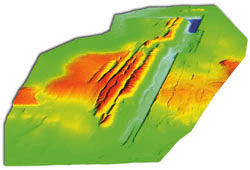 3D color draped elevation map created from more than 1.3 million LIDAR laser data points. 3D color draped elevation map created from more than 1.3 million LIDAR laser data points. "LIDAR required essentially no field prep work on the day of the flight, and we had our map points delivered to us a week later," said George Leupold, Black Butte project engineer. "But the real kicker is the price. We can't beat it."
he cost for a LIDAR mapping project runs about 40 percent less than one using standard air photos. Lasers have been used in various types of measurement applications since the 1950s. But only in the last 10 years have advancements in the technology made LIDAR a commercially viable tool for mapping from an aircraft. In the past five years, LIDAR has become one of the fastest growing remote sensing technologies.
Despite the widespread use of LIDAR in terrain mapping applications that range from utility corridor siting to wireless telecommunications design, its utilization in open pit mining has been slow to develop.
"LIDAR measures light reflections off the ground, and the problem with open pit mines is that the black coal absorbs too much of the light for most systems to record a reflection," explained Don Wicks, president of EnerQuest Systems LLC. EnerQuest is the Denver firm hired to map Black Butte with its advanced LIDAR.
Personnel in the Kiewit Mining Group, the managing firm that oversees Black Butte operations, are those responsible for introducing Leupold to EnerQuest. Kiewit had previously contracted EnerQuest for several non-mining mapping projects and correctly determined that its LIDAR system was robust enough to map coal seams in an open pit mine. EnerQuest performed its first mapping at Black Butte in mid-1999. Mapping at the Speed of Light
LIDAR utilizes a scanning laser altimeter to directly measure the latitude, longitude and elevation coordinates of ground points by emitting light pulses toward the ground from the unit in the aircraft. When these pulses reflect off the surface, their return is received and timed by the device, which then calculates the precise distance between the aircraft and the ground point based upon the constant speed of light.
Because LIDAR is integrated aboard the aircraft with both an inertial measurement unit and a global positioning system, the device's exact location, altitude, and position are known quantities and can be used to determine the geographic coordinates of each ground point. For ground control, only a single survey point on the surface needs to be located to tie the LIDAR mapping into a standard coordinate system.
This direct measurement of point coordinates contrasts sharply with the more traditional photogrammetric method of using overlapping aerial photographs, known as stereo-pairs. In this technique, the photographed area must be marked in advance with numerous survey points on the ground so that photogrammetric processes can be applied to interpolate elevations and coordinates of surface features.
"The accuracy of the older technique was sufficient for our needs, but we often had to wait for up to four weeks for results," said Leupold. "The biggest hassle, however, was marking those ground control points with 12-foot panels the day before the flight. It was very labor-intensive, and sometimes the panels blew away or got covered with snow overnight."
The EnerQuest LIDAR, known as RAMS (Remote Airborne Mapping System), appealed to Black Butte because it eliminated both delivery and ground control problems, plus it was capable of overcoming the light absorption issue peculiar to coal mining. RAMS operates at a frequency of 15kHz, which allows it to measure points at a spacing of every three meters over an average swath width of 7250 feet, or roughly 250,000 points per square mile. Spacing of contours in the elevation maps generated from this data set ranges from one to five feet. Absolute elevation accuracy is six inches, with a relative accuracy of about two inches.
Two key design elements set RAMS apart from other commercial LIDAR systems. The first is the diameter of the aperture on the laser altimeter. The RAMS aperture, which serves as a collector of the light pulses that bounce off the ground, measures six inches across. Most apertures on other LIDAR systems average only two to three inches in diameter.
"This larger diameter enables RAMS to capture more reflected light over a given area," said Wicks. "As a result, even if most of the light is absorbed by the coal, our system can still collect whatever small amount is reflected."
When EnerQuest designed its system with a larger-than-normal aperture, it did not have open pit mapping in mind. This larger aperture allows the RAMS system to operate at higher altitudes so that broader areas can be mapped over a shorter period of time.
The other difference in the EnerQuest system is that it has a large-format digital stereo imaging sensor integrated with the laser altimeter. This means it can acquire photographic images simultaneously with terrain coordinates. Surface details appearing in the imagery assist EnerQuest technicians in checking the quality of the elevation data.
"A lot of customers who are used to dealing with aerial photography like to receive a photographic image along with their map points to get an overview of their project area," added Wicks. Mapping and Modeling at Black Butte
The Black Butte dragline operation has been producing sub-bituminous coal from the Almond and Fort Union formations for 21 years. Currently, four active pits located about 35 miles east of Rock Springs generate an annual contract output of three million tons. Dragline operations at Black Butte are utilizing innovative methods to uncover thin coal seams in areas where overburden depths are about 240 feet.
"We map our sites at least twice a year for permitting, reclamation and volumetric calculations," said Leupold. "We have USGS maps with 20-foot contour intervals of our outlying areas, but for day-to-day design work in and around the pits we need five-foot contours on our maps."
Black Butte has employed digital mapping technology for several years, requiring its aerial survey firms to deliver contour data in digital files. These contour lines are loaded into Minescape version 4.0 - mine modeling software from Mincom Inc. of Denver - to create three-dimensional models of the pits and the coal seams.
"Mapping inside the pit allows us to check our model to make sure it's predicting properly," said Leupold. "The importance of mapping outside the pit is to model the overburden so we can determine where our economic cutoffs are."
The main producing seams in the mine dip eastward at a six-degree angle. In each cut, the operator applies economic criteria to the volumetric results from the model to determine the precise point where the overburden become too great for the coal to be extracted profitably. Applying LIDAR
Prior to each RAMS flight, Leupold and his team of engineers decide which areas of the mine need to be updated. Using the Minescape software, he draws polygons around the targets on a digital map and e-mails the file to EnerQuest in Denver. Technicians there input the map into an automated flight planning software to set up flight lines for the acquisition. Operating parameters of the LIDAR can be adjusted to meet specific user requirements for point spacing and contour interval. The five-foot contours requested by Leupold were well within system capabilities.
Before the first mission in 1999, EnerQuest personnel visited the site, primarily to determine the survey coordinate system already in use there. In many mapping projects, EnerQuest finds that clients have established their own coordinates or else tied into an obscure local system. This circumstance requires the LIDAR firm to perform additional processing on the acquired data points for conversion to the desired coordinate system.
"This wasn't an issue at Black Butte. They had already tied their previous mapping into the standard [National Geodetic Survey] system," said Wicks. "In fact, Black Butte had a GPS base station set up on an NGS point, so we used their base station to correct the data received by the RAMS GPS onboard the aircraft."
EnerQuest mapped 2600 acres in the first project, including four active pits and one under reclamation. Collection of the data by RAMS took less than an hour in each project. EnerQuest processed the data at its headquarters and e-mailed the files to Black Butte in under a week. It should be noted that the average file size was only 25 megabytes.
"Within 15 minutes after I downloaded the file from my e-mail, I was building a new contour surface in the modeling software," said Leupold. "Data points are delivered in the exact file format I need."
As expected, the RAMS system has succeeded in mapping both the coal seam surfaces inside the pit and the overburden terrain around the pit with equal accuracy. There have been no distorting effects caused by light pulse absorption in the coal seam, and contour intervals of the resulting LIDAR maps have either met or exceeded the five-foot requirement. About the Author:
Kevin Corbley is the principal in Corbley Communications Inc., Littleton, Colo. He may be reached by telephone at (303) 979-3232, or via e-mail at [email protected]. Back |

