
|
 |
|
L.A
County Combines IFSAR with Digital Imaging to Produce Accurate Orthos
& DEMS Los Angeles County, Calif., built an orthorectified basemap for its GIS for 20 percent of the cost than would have been required with traditional photogrammetry, and in less time, by combining two advanced aerial mapping technologies: a digital optical sensor for imaging, and synthetic aperture radar for measuring elevation. "What made this project such a challenge was our need for highly accurate data over a very large region," said Milan Svitek, GIS section head and project manager for the L.A. County Department of Regional Planning. Svitek explained that cities and counties covering small geographic areas can often afford the going rate for airborne stereo acquisition, ground surveying, and photogrammetric processing services that yield highly accurate orthophotos and digital elevation models (DEMs). However, L.A. County did not have the estimated $8 million required to map its sprawling 4000 square miles with these manually intensive techniques.
"We also couldn’t wait a couple of years for delivery," Svitek added. In January 2001, the county contracted with Emerge (Andover, Mass.), a provider of all-digital airborne imaging and processing services, to produce the orthorectified base map. The county also wanted final delivery to include DEMs and contours to support a recently initiated watershed management program. Ortho-imagery specifications called for 0.3-meter (one-foot) resolution with one-meter accuracy over nearly 3000 square miles of the county’s coastal and urban areas, and one-meter resolution with two-meter accuracy for the remaining 1000 square miles of national forest land. In addition, L.A. County requested DEMs with one-meter vertical accuracy and five-meter post spacing, along with contours at three-meter (10-foot) intervals. "One-foot image resolution is no problem for our system, but orthorectification accuracy depends on the elevation data used to produce it," said Drew Fisher, director of imagery sales for Emerge. "We knew that the USGS DEMs typically used for orthorectification wouldn’t be sufficient for this project." Emerge worked with the L.A. County GIS section to research options for acquiring the necessary elevation data. The search was quickly narrowed to LIDAR (Light Detection and Ranging) and IFSAR (Interferometric Synthetic Aperture Radar), both of which could satisfy the desired one-meter accuracy specification. "When we compared the price of these two technologies, IFSAR was much more cost-effective for a project of this size," said Fisher. Once the technology was chosen, selecting an IFSAR operator as a partner in this project was an easy decision. Intermap Technologies (Calgary, Alberta, Canada) developed the original airborne IFSAR mapping technique and remains the leading international provider of commercial services in this field. In early 2001, L.A. County contracted with Intermap to collect elevation data for the project with its STAR-3i IFSAR mapping system. Intermap and Emerge collaborated to complete data acquisition and deliver end-user products before the March 2002 deadline. Watershed Management Drove Specifications As is true with most mapping projects, data specifications for L.A. County were driven by proposed applications. Within the county the public works department, assessor’s office and regional planning department collaborated to spearhead the aerial mapping project and provide a new data layer in the existing county GIS. This countywide system was developed with ArcInfo software by ESRI (Redlands, Calif.). "We were among the first counties to build a countywide GIS," said Greg Kelley, assistant deputy director for the Public Works Mapping and Property Division. "In the past, we used a parcel map as our base layer. This is the first time we have had an orthophoto base map." Later this year there are plans to make the GIS accessible to all county offices via the Web. The new base map will be used as a source of land-use and land-cover information in appraisal, environmental, transportation, traffic and utility applications. An initial analysis of this ortho-imagery suggests that its accuracy is high enough to use in correcting the quality of other GIS layers. The primary requirement for one-meter accuracy in the elevation data, however, came from Watershed Management, a relatively new division within Public Works. Its job is to model storm water runoff and drainage in each of the county’s eight watersheds. The county is in the midst of a major program to redesign existing drainage basins and create new aquifer recharge areas. "Having accurate DEMs and contours as inputs into their computer models enables our hydrologists to determine precisely where rain water goes," said Kelley. "This helps them build control structures to minimize flash floods and replenish the ground water." With surface and ground water models constantly improving in precision, the Watershed Management Division requested that Public Works obtain the highest possible elevation accuracy in this new data set to ensure that it could take full advantage of the latest computer modeling capabilities. IFSAR Offers Many Advantages IFSAR has emerged as an increasingly popular method for acquiring elevation measurements due to its accuracy, speed and cost effectiveness. Technical advantages of the interferometric process account for its high level of vertical accuracy, while rapid and efficient acquisition capabilities relate to operational factors in the STAR-3i system. Intermap has worked for two decades at perfecting the design of airborne IFSAR systems, and STAR-3i is the most advanced and accurate now in commercial operation. It uses two radar antennas mounted on Intermap’s Learjet 36, which allow the system to make Z measurements of ground surfaces on a single pass over the project area. "Highly precise inputs from integrated GPS, plus inertial navigation units also onboard, help refine IFSAR’s X, Y and Z measurements," explained Hugh MacKay, Intermap’s sales manager for Europe and the western United States. During acquisition, one IFSAR antenna emits microwave radar pulses that reflect off the ground and return to the device. Both antennas record the reflected beam. By measuring the phase difference in the return signals between the antennas and combining this information with positional data from onboard location systems, STAR-3i determines elevation values for each ground point. "These direct elevation measurements are calculated at a five-meter spacing, having an accuracy of from 50 centimeters to two meters depending upon the altitude of the Learjet," said MacKay. "To achieve the one-meter accuracy [root mean square error] required by L.A. County, we flew at an altitude of 28,000 feet above the ground." This acquisition altitude, combined with the Learjet’s speed, delivers the superior efficiency for which IFSAR is becoming known. Of course, efficiency translates into financial benefits. By flying at altitudes above 20,000 feet, and often closer to 30,000 feet, STAR-3i acquires data over a swath width of from eight to nine kilometers on a single pass. IFSAR is additionally an active sensor, which means that it provides its own source of imaging illumination and does not need sunshine for operation. This enables the sensor to operate properly in darkness or poor weather – factors that can ground optical cameras – thus squeezing more hours of operation into each day. "In the busy airspace around Los Angeles, it was efficient for us to operate at night when most commercial air traffic had subsided," said MacKay. "We were able to maintain our planned flight lines without interference from other aircraft." Although a Learjet is more expensive to operate than are many other airborne platforms, its speed and operating ceiling more than compensate for this difference, resulting in an extremely cost-effective mapping solution, especially over large areas. "The DEMs we provided L.A. County cost 70 to 80 percent less than what the county would have paid for similar products derived from traditional photogrammetric methods," said MacKay. Acquiring Images and DEMs Emerge operates a fleet of 10 Cessna aircraft in the United States, each equipped with a digital sensor designed and built by the operator. In March 2001, the firm was able to move four aircraft into the Los Angeles area to work simultaneously on this acquisition project. "We felt comfortable working with Intermap because their IFSAR operates similarly to our optical sensors in some fundamental ways," said Emerge’s Fisher. "Both systems use onboard GPS and inertial navigation, which eliminates the need for ground control." To obtain one-foot image resolution, the Emerge aircraft flew at an altitude of 5000 feet and covered 125 square miles per day. Over the Angeles National Forest, where one-meter resolution was requested, Emerge flew slightly higher. Image acquisition, completed in less than five months, was followed by digital orthorectification at the company’s Andover headquarters. "Other than adjusting the altitude to meet resolution requirements, we made no special operational changes to map the county from its coast, across the city, and into the mountains," said Fisher. As Emerge was beginning its acquisition, so was Intermap. Its Learjet arrived in March and completed data acquisition over the entire 4000-square-mile area in less than three weeks. Raw data was received for processing at Intermap’s facility in Ottawa, Ontario. "Coordinating two acquisition projects was really easier than it sounds," said MacKay. "We simply used the same geoidal reference points and projection systems as Emerge to ensure that our elevation data georeferenced with their image data." Elevation data processing gave Intermap the opportunity to employ its recently developed Terrain Fit software. The company developed this automated process to strip away elevation points for trees, houses and other features that sit on the Earth’s surface. The result is a data set called a Bald Earth DEM, or digital surface model. "Many GIS applications, especially watershed modeling, require elevation points for the ground surface, not features above the ground," said MacKay. "This was our first commercial application of Terrain Fit, and it was highly successful." Intermap began delivering DEMs to Emerge for orthorectification immediately following processing in Ottawa. All of the elevation points were in Emerge’s hands by July 2001, allowing it to complete its delivery of the mosaicked digital ortho-image to L.A. County by March 2002. As part of the agreement, Intermap delivered separate DEM and three-meter contour products to the county, but retained the rights to the original data. "The L.A. County elevation data is now available for sale directly from our online GLOBAL Terrain archive," said MacKay. The county’s Regional Planning Department handled quality control checks on all data sets. "We are very pleased with the new base map," said Svitek. "Accuracy met or exceeded our expectations." Combined Operations Becoming Common Fisher and MacKay agree that secondary acquisition of elevation data to support orthorectification processes will grow considerably in the future. Intermap has already received contracts from several Space Imaging resellers who need faster and cheaper elevation data for delivering orthorectified IKONOS images to end users. "Providing DEMs for the orthorectification of traditional and digital imaging techniques is a growing part of our business," said MacKay. "This L.A. County project has proven the capability of airborne IFSAR at the county and regional level to support airborne imaging, as well as space-borne." Mapping experts in Los Angeles say that this new combined technology process is economical and very practical. "Los Angeles County extends from the beach
to the city, and across the desert to the mountains, covering every conceivable
terrain and land-cover type," said Svitek. "If this project
can be accomplished here, it can be done anywhere." |
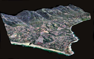 This
perspective view of Point Dumme State Beach in Los Angeles County was
created by draping mPOWER3 emerge imagery over Intermap Technologies'
one-meter Digital Terrain Models.
This
perspective view of Point Dumme State Beach in Los Angeles County was
created by draping mPOWER3 emerge imagery over Intermap Technologies'
one-meter Digital Terrain Models.