| An Application of GIS in Underground Mining
By Anthony Hammond Abstract
The use of Geographic Information Systems (GIS) is gathering momentum in the mining industry as a powerful tool for analyzing and displaying data. Of particular interest is the ability of GIS to link spatial features to tabular data. This capability is applied here to a series of CAD drawing layers, associating a table of attributes to the various features of the drawing in an effort to consolidate both components into a useful management tool.
This application of GIS in underground mining concentrates on four technical areas: land ownership and mineral claims, exploration management, production, and mine safety. The benefits to consolidating and archiving claims data, and the ability to georeference property maps defined in local coordinates into a state coordinate system, is of paramount importance to a land and exploration manager. In the production area, GIS facilitates the optimal siting and querying of service installations as related to production centers for meeting production parameters. In mine safety, the siting of refuge chambers relative to production centers is optimized, and areas of potential safety concerns are identified, by utilizing a GIS proximity analysis. The same applies to finding the shortest route to emergency exits and the preparation of maps to facilitate the prompt evacuation of mine personnel. 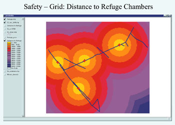
Figure 6: GIS in mine safety: distance to refuge chambers and emergency exits using proximity analysis. Introduction
The use of GIS within the natural resources industry is widely recognized; however, its use in technical applications in the mining industry lags behind other disciplines the overall field. The reason for this may be due, to some extent, to the popularity of CAD (computer-aided drafting) and its interface with specialty mining software. The versatility of DXF-formatted files allows easy transfer of files between the two systems.
The increased popularity and technological advances in GIS in recent years has introduced a new element in the aforementioned relations, complementing the design capabilities of CAD with GIS's robust link between spatial and tabular components (Figure 1). These features catapulted GIS into the role of the preferred tool for planning and analysis, thus allowing the integration of communications across departmental, divisional, and corporate boundaries. This cross-boundary integration is undoubtedly the way present and future communications will flow in the mining industry, as the commodities market, environmental regulations, and government policies force mining companies to become more competitive and cost-effective. Moreover, state and federal agencies involved in the mine-permitting process are adopting the GIS format as their standard for communicating spatial data.
The twin processes of mine modeling and mine planning produce abundant maps and databases that reflect multiple scenarios. Planning engineers submit this information for the review of engineering, exploration, mine operations, environmental, land, financial, legal, and management divisions (Figure 2). At this stage of the integration process specialty mining software ceases to be an effective tool, leaving GIS as the ideal choice for a variety of planning and analysis scenarios across multiple disciplines.
The application of GIS in environmental, mine remediation, and reclamation has been extensively tested and documented. However, the same is not true in the area of technical mining applications. This article describes examples of technical applications in underground mining that involve four specific areas: land ownership and mineral claims, exploration management, production, and mine safety. The examples presented here correspond to a mineral property located in Ouray County, Colo. The spatial data was imported from AutoCAD drawings by using ESRI's ArcView GIS CAD Reader extension. All GIS applications outlined here were carried out using ESRI's ArcView GIS software. Land Ownership and Mineral Claims
Land managers can benefit from GIS capabilities in tracking land leases, acquisitions, royalties, and mine expansions. The table of attributes has fields for claim number and description, owner's name, category (whether patented or unpatented), royalty interest, survey control (including name, coordinates, elevation, description of the monument), county zoning boundaries, township, range, section boundaries, and many more. (Figure 3).
Mineral claims can be classified and summarized by a field within the table of attributes, e.g., patented claims. The "summarize" command consolidates claims by category, allowing the user to specify an attribute such as area for the summary-by-category function. Another area of interest for the land manager is to determine which claims might be affected in a mine expansion. The user digitizes or imports the polygon that outlines the expansion, and then uses ArcView's "select by theme" capability to produce a map and table showing all claims affected by this expansion. Furthermore, these claims can be summarized by claim category, and the user can even obtain statistics and prepare detailed reports. Exploration Management
For an exploration manager in the process of evaluating various mineral properties, GIS is a versatile tool for data consolidation, archiving, and quickly gaining access to information. In today's global economy, a mineral exploration organization typically controls various mineral properties in various stages of development, scattered around the globe. The implementation of GIS allows the exploration manager to georeference these properties and tap into a wealth of information - made public on the Internet - in the form of DEMs (digital elevation models), DRG (Digital Rater Graphics), DLG (Digital Line Graph), coverages, orthoquads, etc. These mineral properties are typically defined in a local coordinate system; GIS enables the user to consolidate and georeference these properties into a world coordinate system.
The exploration manager can take advantage of the GIS link between spatial and tabular data to access specific information such as assay, geotechnical, cadastral, metallurgical, environmental, and permitting data to prepare contour maps and explore other thematic layers of interest that include grade distribution, soil types, vegetation, cultural, wildlife, slope and aspect surfaces, and neighborhood and zonal statistics (Figure 4). Likewise, the exploration manager can benefit from the powerful 3D elements of GIS in performing a visibility analysis of surface installations and displaying underground features in 3D. Production
In the area of production, GIS is ideally suited to assist production and engineering planners in confronting the routine challenges of a mining operation. In particular, the siting and querying of service facilities relative to the main production centers is a strong feature of GIS. Examples of these are numerous, among them:
• Siting of orepass, drawpoints, ramps, shaft, winze, raises, and haulways that are within a certain distance of production centers (stopes) and that also meet certain production criteria (Figure 5).
• Querying the production stopes affected by unstable ground conditions, hazardous gas, refractory ore, etc.
• In mine development, GIS can assist the planners in establishing the optimal location for exploration drifts, crosscuts, sublevels, manways, and ventilation shafts.
• In service and ancillary systems, planners and engineers can use GIS to find the lowest-cost path for routing delivery of supplies to working areas, find the closest facility, assign proximity ratings, model inaccessible areas, and model mine ventilation networks using the "Geometric Network" feature. Mine Safety
Mine safety is of paramount concern to the mining industry. In an effort to achieve a balance of safety and productivity, GIS can contribute to the creation of a safe working environment in underground mining by performing network analysis and determining sites for refuge chambers and the safest routes for the prompt evacuation of mine personnel.
The siting of refuge chambers within a safe distance from production stopes can be achieved with a GIS proximity analysis. A network of refuge chambers can be implemented that possesses adequate capacity and the correct number of first aid kits proportionate to the miner population. This same benefit applies to mapping the nearest exit and identifying the shortest route from various working centers by creating a distance grid (Figure 6). To this effect, the creation of miner concentration grids is useful in finding potential areas of concern in the event the distance from production centers and refuge chamber capacity does not meet safety levels as dictated by company policy and governmental regulations. Other Applications of GIS in Mining
Other uses of GIS technology in the mining industry include:
• Transport routes - Mine planners utilize GIS, in combination with remote sensing, to plan the best routes for transporting goods and supplies from the nearest community to the mine site. Integrating thematic layers such as topography, land ownership, land-use, population, and climatic conditions can facilitate the objective selection of economical and environmentally preferable alternatives.
• Natural hazards - GIS and remote sensing assist the planners in identifying natural hazards such as potential landslides, floods, earthquakes, and volcanic eruptions prior to the construction of production and housing installations.
• Population distribution - Planners of a new mine may need information on population density, socio-economic distribution, labor resources, housing, and recreational infrastructure in the preparation of the environmental impact assessment.
• Selection of sites for housing and dumps - GIS can aid in the selection of a housing site that meets safety, scenic, and recreational requirement within reasonable proximity to the mining operation. Topographic, vegetation, drainage, and soils coverage, together with concentration levels of toxic substances, can be incorporated into any such analysis. Conclusion
In today's complex and competitive business environment, GIS offers multiple applications in the mining industry with tools to gather, compile, process, display, analyze, and archive extensive volumes of data. The analytical features of GIS facilitate the integration of communication across departmental boundaries within a modern mining organization. The posting of geographic data in an intranet or Internet system allows the dissemination of mine data in a client-server configuration for review by remote users. A well designed, implemented, and supported GIS department is instrumental in the success of any mining operation. About the Author:
Anthony D. Hammond is a mining engineer with nineteen years experience in mining operations. Following the completion of his GIS Certificate, Mr. Hammond is currently working on the development of GIS applications within the mining industry. He may be reached via e-mail at [email protected] Back |

